
Imagery and Sensing
-
 Government/Military
Planet to Support NASA Relay Networks for Telesat, SES
Planet Labs will support operators SES and Telesat as a subcontractor on their space relay projects for NASA. Planet will work with the operators on the Communication Services Project (CSP) […]
-
 Imagery and Sensing
OroraTech CEO on How Satellite Data Can Transform Wildfire Management
The European space startup scene is home to a number of companies involved in climate monitoring and mitigating the impacts of climate change. One such company that is looking to […]
-
 Government/Military
Iceye to Dedicate Satellite for Ukrainian Government Use
Iceye is providing the government of Ukraine with its synthetic aperture radar (SAR) satellite imaging capabilities, signing a contract with the Serhiy Prytula Charity Foundation. As part of the agreement, […]
-
 Government/Military
Ursa Space, Spire Partner on Maritime Domain Awareness Services for Government
Ursa Space Systems and Spire Global, two commercial companies that provide remote sensing services to government and other customers, have formalized a partnership to combine their capabilities for detecting illicit maritime activity for […]
-
 Imagery and Sensing
Capella Space Announces Higher-Performance Next-Gen Satellites With Optical Links
Capella Space, a synthetic aperture radar (SAR) data company, announced the next-generation of its satellites called Acadia, which will offer higher resolution and be equipped with optical inter-satellite links. The […]
-
 Imagery and Sensing
Orbit Launches New Earth Observation Antenna System, Gaia 100
Orbit Communications Systems is launching a new antenna system as it looks to target more business in the Earth observation (EO) market, to go alongside its core mobility markets. It […]
-
 Imagery and Sensing
GHGSat Doubles Capacity to Better Track Methane Emissions
GHGSat, a company playing a role in the climate change arena thanks to its high resolution methane monitoring satellites, has doubled capacity after the launch of three new satellites. GHGSat […]
-
 Finance
Private Equity Firm Acquires Controlling Interest in Descartes Labs
Private equity firm Affiliates of Antarctica Capital has acquired a controlling interest in geospatial intelligence company Descartes Labs. The deal was announced on August 4, and financial terms were not […]
-
 Imagery and Sensing
Spire Inks Second Optical Payload Deal with South Korea’s Hancom inSpace
South Korean satellite data and technology company Hancom inSpace (Hancom) has signed its second contract with Spire Global to host an additional optical payload on a Spire 6U satellite that […]
-
 Imagery and Sensing
Under New Partnership, BlackSky Gets Reseller Access to Airbus Imagery Products
Virginia-based geospatial intelligence and satellite imagery provider BlackSky Technology secured reseller rights to 23 different tasking and archive imagery products owned by Airbus under the terms of a new partnership […]
-
 Imagery and Sensing
ESA Confirms Loss of Sentinel-1B, Will Now Fast-Track Sentinel-1C Launch
ESA and the European Commission confirmed Wednesday that they have lost the Copernicus Sentinel-1B Earth observation satellite after it experienced a power supply failure in December that left it unable […]
-
 Government/Military
Ball Aerospace Wins Two More NASA GeoXO Study Contracts
Ball Aerospace secured two contracts with NASA to support the NOAA’s next-generation geostationary weather satellite constellation under the Geostationary Extended Observations (GeoXO) program. The space systems manufacturer said on Monday […]
-
Government/Military
Lockheed Martin and Maxar to Develop Concepts for NOAA GeoXO Satellites
Lockheed Martin and Maxar Technologies have been tasked with developing the concepts for the National Oceanic and Atmospheric Administration’s (NOAA) next-generation GeoXO program. NASA awarded the companies $5 million, 10-month firm-fixed-price […]
-
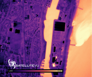 Manufacturing
Satellite Vu Orders Second Thermal Imaging Satellite from SSTL
Satellite Vu has commissioned a second satellite from Surrey Satellite Technology Ltd. (SSTL) to grow its thermal imaging collection capacity. The U.K. satellite startup is working to build a constellation […]
-
 Manufacturing
Members of Congress Cut Ribbon on Hawkeye 360’s New Manufacturing Facility in Virginia
Members of U.S. Congress joined HawkEye 360 CEO John Serafini on Friday to cut the ribbon on the company’s brand new 19,000-square foot satellite manufacturing facility in Herndon, Virginia. U.S. […]
-
 Imagery and Sensing
Thales and QinetiQ to Study VLEO Skimsats Under ESA Contract
The European Space Agency gave Thales Alenia Space and QinetiQ a study contract to pave the way for small multi-mission satellites to operate in Very Low-Earth Orbit (VLEO). In the […]
-
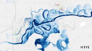 Imagery and Sensing
ICEYE to Take Part in Ghana Flood Project
Iceye will participate in a risk transfer project with the Ghana Ministry of Finance, the United Nations Development Programme (UNDP), and the Insurance Development Forum (IDF), the company announced July […]
-
 Government/Military
BlackSky Wins IARPA Award to Support Analysis Automation Project SMART
The Intelligence Advanced Research Projects Activity (IARPA) has awarded BlackSky a second award to support a research program to automate analysis of satellite imagery. On Thursday, BlackSky announced the $4.4 […]
-
 Imagery and Sensing
Capella Space Adds Satellite Imagery to AWS Open Data Registry
Capella Space is adding a selection of its synthetic aperture radar (SAR) imagery to the Amazon Web Services (AWS) Open Data Sponsorship Program to make it openly accessible. The company […]
-
 Government/Military
Planet Wins German Federal Agency Contract
Planet has won a new contract with one of Germany’s federal agencies. The company announced July 13 that it had signed a contract with the German Federal Agency for Cartography […]
-
 Imagery and Sensing
SatSure Forms KaleidEO to Build Optical Payloads In-House
Space data and analytics company SatSure is launching a new subsidiary, KaleidEO, to build optical payloads to collect satellite imagery. SatSure said in a Tuesday announcement that it incubated the […]
-
 Government/Military
Biden Administration Directs Use of Technology to Combat IUU Fishing
President Biden on Monday issued a National Security Memorandum (NSM) aimed at combating illegal fishing by distant water fleets in the world’s oceans and directed several departments and agencies to […]
-
 Imagery and Sensing
MDA Gives Global Fishing Watch Access to the Radarsat Archive
MDA is providing Global Fishing Watch access to the company’s Radarsat-2 satellite radar archive to fight illegal fishing practices. MDA announced the agreement on June 28 as part of the […]
-
Imagery and Sensing
Iceye Now Offers Governments and Companies Their Own SAR Satellites
Iceye is expanding its business to now give governments and large multinational corporations the option to purchase their own radar imaging satellites. As part of the new Missions line of […]
-
 Imagery and Sensing
Telespazio Signs Reseller Agreement With BlackSky
Telespazio has signed a new deal with BlackSky which will enable the company to make BlackSky geospatial products and services commercially available to customers world-wide. The non-exclusive reseller agreement was […]
-
 Imagery and Sensing
NanoAvionics Sells In-Orbit Satellite Equipped With Hyperspectral Imager
NanoAvionics recently sold one of its operational satellites in Low-Earth Orbit (LEO), a first for the company. The 6U satellite “D2 / Atlacom-1,” which included a 1U-sized hyperspectral imager for […]
-
Government/Military
NASA Awards Spire Global $6 Million Contract Extension for Earth Observation Data
Spire Global received a $6 million, year-long extension from NASA for the agency’s Commercial Smallsat Data Acquisition (CSDA) Program. Spire announced the extension on June 23. The CSDA allows NASA […]
-
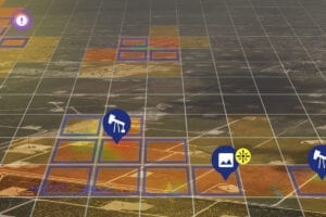
 Imagery and Sensing
Energy Transfer Taps Orbital Sidekick to Monitor Pipeline Assets
Energy infrastructure company Energy Transfer has selected Orbital Sidekick to monitor its assets in the Permian Basin with satellite technology. Orbital Sidekick’s hyperspectral monitoring technology will allow Energy Transfer to […]
-
 Government/Military
BlackSky Wins AI Contract from Joint Artificial Intelligence Center
The U.S. Department of Defense (DoD) awarded BlackSky Technologies a contract worth up to $241 million over five years to create and optimize data sets for use in DoD AI […]
-
 Technology
Orbit Logic Wins New Software Deal with Satellite Vu
Satellite Vu will use Orbit Logic’s collection planning software for the operation of its planned constellation of high-resolution thermal imaging satellites, the two companies announced June 21. Orbit Logic will […]