
Imagery and Sensing
-
 Imagery and Sensing
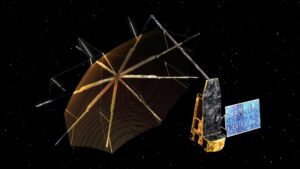
Synspective to Distribute SAR Solutions in North America With Frontier Precision
Japanese synthetic aperture radar (SAR) company Synspective will now distribute its SAR solutions in North America, through a new distribution partnership with Frontier Precision. Frontier Precision, based in North Dakota, […]
-
 Finance
Maxar Acquires Wovenware to Strengthen AI Capabilities
Maxar Technologies on Thursday said it acquired Wovenware, which specializes in artificial intelligence and software developing, and will make the Puerto Rico-based company one of its software development and AI/machine learning […]
-
 Government/Military
NRO Expects to Release Hyperspectral Satellite RFP By the End of 2022
RESTON, VA — The National Reconnaissance Office (NRO) is close to finishing a request for proposals to acquire commercial hyperspectral satellite data and hopes to release an RFP by the […]
-
 Government/Military
Spire Wins DARPA Contract to Design ‘Ouija’ Satellite
The Defense Advanced Research Projects Agency (DARPA) awarded Spire Global a contract to design a satellite to carry sensors to measure the ionosphere. The contract is part of DARPA’s Ouija […]
-
 Imagery and Sensing
NorthStar Earth & Space, Spire Satellites to Launch With Virgin Orbit in 2023
Virgin Orbit will launch satellites for Spire Global, including three satellites dedicated to the NorthStar Earth & Space space situational awareness (SSA) constellation, in mid-2023. NorthStar is using Spire’s space […]
-
 Government/Military
Iceye Flood Data Assists FEMA in Recent Flood Events
Iceye is working with partners New Light Technologies (NLT) and Bana Solutions (Bana) to give flood insights to the Federal Emergency Management Agency (FEMA), covering four recent major flood events. […]
-
 Imagery and Sensing
Mission Space Partners with Sidus Space to Collect Space Weather Data
Mission Space signed an MoU with Sidus Space to partner on space weather intelligence data collection. Luxembourg-based startup Mission space is working to monitor space weather. It will deploy its […]
-
 Government/Military
Asian Government Ally Signs $10M Contract for BlackSky Imagery
BlackSky Technology received a one-year, follow-on contract worth $10 million to provide an international ministry of defense customer in Asia. The Tuesday announcement was short on details about the unnamed […]
-
 Imagery and Sensing
Planet Launches Nonprofit Program for Imagery Access
Planet launched a nonprofit program to provide access to the company’s satellite imagery. The program provides access to Planet imagery and support services for nonprofits and non-governmental organizations with the goal […]
-
 Government/Military
Swedish Space Corporation Ready to Support New ESA Mission
Swedish Space Corporation (SSC) has signed a contract with the European Space Agency (ESA) which will see it provide data reception support of the Biomass satellite scheduled for launch in late […]
-
 Imagery and Sensing
Aireon Selected to Provide Space-Based Air Traffic Data in Azerbaijan
Aireon has won a new deal in the air traffic market. It will provide its space-based Automatic Dependent Surveillance-Broadcast (ADS-B) data for air traffic surveillance in Azerbaijan airspace, as a […]
-
 Government/Military
New U.S. Arctic Strategy Directs Investments In Domain Awareness and Communications
U.S. security in the Arctic will require a range of expanded capabilities including improved domain awareness, positioning and communications, more Coast Guard icebreakers and investing in maritime transportation infrastructure, the […]
-
 Imagery and Sensing
Rocket Lab Launches General Atomics-Built Satellite to Support Argos Constellation
Rocket Lab launched a satellite on Friday afternoon for General Atomics Electromagnetic Systems (GA-EMS) to support the Argos constellation, a network of polar orbiting satellites that collect data on the […]
-
 Imagery and Sensing
HawkEye 360 Plans to Have 60 Satellites on Orbit By 2025
Virginia-based HawkEye 360 plans to have 60 satellites — 20 clusters of three satellites — on orbit by 2025, Alex Fox, the company’s chief growth officer, said this week. The company […]
-
 Technology
Exobotics Teams Up With Simera Sense on Hyperspectral Imager
Exobotics is teaming up with Simera Sense, one of Africa’s up and coming space startups, to engineer and integrate a hyperspectral imager into one of their nanosatellite platforms. The two […]
-
 Government/Military
NRO Dishes Out Six New RF Study Contracts to the Satellite Industry
The National Reconnaissance Office (NRO) has signed a slew of new study contracts in the commercial radio frequency (RF) remote sensing arena. The NRO announced the contracts Sept. 28. Companies […]
-
 Imagery and Sensing
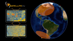
Satellite Vu Strikes Deal to Use Viasat’s Ground Network Service
Satellite Vu, one of the up and coming U.K. space companies, has signed a deal with Viasat to use its Real-Time Earth global ground service network to ensure rapid reception […]
-
 Imagery and Sensing
Satellogic to Monitor Protected Forests in Climate Change Contract
Satellogic has won a contract to monitor all subnational protected areas on the planet through the new Green+ Jurisdictional Programme, the company announced Sept. 26. The provision of satellite data […]
-
 Imagery and Sensing
Celestia UK to Develop PNT Solution With LEO Networks for ESA
Celestia UK won a European Space Agency (ESA) contract to develop a PNT solution based on Low-Earth Orbit (LEO) satellite constellations for 5G networks and applications. The contract, worth 800,000 […]
-
 Government/Military
Spire, Lockheed Martin, BAE and Others Receive NOAA Awards for New Technologies
The National Oceanographic and Oceanic Administration (NOAA) is funding nine awards totaling $13.8 million to industry and federal agencies to produce new concepts for instrument technologies, ground systems and other […]
-
 Imagery and Sensing
Satellite Vu Taps SpaceX for its Second Satellite Launch
Satellite Vu will use SpaceX to launch its second satellite, the company announced Sept. 22. The deal will see Satellite Vu’s mid-wave infrared (MWIR) imaging satellite launched into Sun-Synchronous Orbit […]
-
 Imagery and Sensing
Open Cosmos to Launch OpenConstellation to Democratize Satellite Imagery
Open Cosmos is preparing to launch the first satellites of a newly-announced OpenConstellation, meant to democratize access to satellite imagery through a shared infrastructure. The OpenConstellation, announced Wednesday, will first […]
-
 Government/Military
NGA Renews Maxar’s G-EGD Imagery Contract for Third Option Year
The U.S. National Geospatial-Intelligence Agency (NGA) renewed its contract with Maxar Technologies for the Global Enhanced GEOINT Delivery (G-EGD) program. The G-EGD program, started in 2011, provides unclassified imagery to […]
-
 Imagery and Sensing
Planet’s Hyperspectral Tanager Satellites Will Have More Than 400 Spectral Bands
Planet announced Monday that its hyperspectral satellites with the Carbon Mapper Coalition will have 30-meter resolution and cover more than 400 spectral bands. The company said these hyperspectral Tanager satellites […]
-
 Imagery and Sensing
Earth Observation Market Sees Growth in 3D Mapping and Multi-Sensor Solutions
PARIS — Defense and intelligence customers for satellite imagery are demanding real-time and more precise imagery and monitoring, multi-sensor datasets, and 3D mapping technologies, Earth observation (EO) operators said Thursday […]
-
 Imagery and Sensing
Iceye and Satlantis Plan Combined SAR/EO Constellation, Tandem4EO
Iceye and Satlantis are pursuing an Earth observation (EO) constellation with both synthetic aperture radar (SAR) and optical imaging. The two European startups announced plans for the four-satellite Tandem4EO constellation […]
-
 Imagery and Sensing
Spire Global Signs Space Services Deal With GHGSat for Methane Monitoring
Spire Global has signed GHGSat as a new customer for its space services segment, and will launch three 16U satellites in 2023 that to GHGSat’s greenhouse gas-monitoring payload. GHGSat currently […]
-
 Government/Military
BAE Systems Announces Multi-Sensor Azalea Satellite Cluster
BAE Systems announced plans to launch its own multi-sensor satellite cluster called Azalea for U.K. military intelligence. Azalea is planned as a cluster of three multi-sensor satellites from BAE Systems […]
-
Government/Military
NASA Awards BlackSky $1.7M Contract for Imaging for Earth Science Research
NASA placed a $1.7 million call order with BlackSky to evaluate the company’s imaging data services for Earth science research. The call order was issued under a five-year Commercial Smallsat […]
-
Government/Military
HawkEye Signs R&D Agreement with US Army to Evaluate RF Data
HawkEye 360 has signed a two-year Cooperative Research and Development Agreement (CRADA) to demonstrate its technology to the U.S. Army Space and Missile Defense Command (SMDC). The CRADA will explore […]