
Imagery and Sensing
-
 Imagery and Sensing
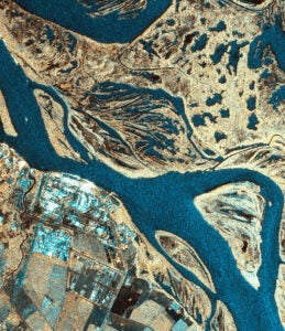
Simera Sense to Supply Imagers for Canary Islands Satellite Constellation
Telespazio Ibérica has selected Simera Sense to supply multispectral imagers for the Canary Islands satellite constellation project. The Canary Islands are a Spanish group of islands off the coast of […]
-
 Imagery and Sensing
Commercial Markets Are Ready for EO — But the Understanding Gap Persists
At the recent EO Summit in London, Earth Observation (EO) experts explained the industry must face the challenge of how to explain its solutions to customers in terms of the […]
-
 Imagery and Sensing
Vantor and Rheinmetall Plan Joint Venture for Sovereign Space in Germany
Vantor and German defense manufacturer Rheinmetall plan to form a joint venture to focus on sovereign space capabilities in Germany and Europe. The two companies announced an MoU on June […]
-
 Imagery and Sensing
Another Earth Expands Into Brazil
Another Earth, an Earth Observation (EO) data company, is expanding into Brazil, one of the largest markets in Latin America. The company believes Brazil’s combination of climate pressures, rapid growth […]
-
 Imagery and Sensing
Airbus to Lead German Consortium for Sovereign ISR Capability
Airbus has put together a consortium of German companies to develop a sovereign intelligence, surveillance, and reconnaissance (ISR) solution. The team announced Wednesday during the Berlin Air Show includes Rohde […]
-
 Finance
Iceye’s Valuation Soars to 10 Billion Euro With New Raise
Iceye’s valuation has jumped to 10 billion euro ($12 billion) after a new funding round on Tuesday, led by General Atlantic. Iceye raised 450 million euro ($520 million) in a […]
-
 Imagery and Sensing
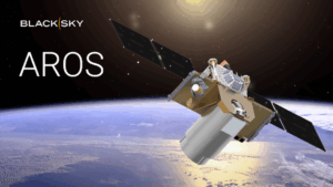
NRO Awards BlackSky Multi-Million Dollar Modification to Accelerate AROS Development
BlackSky Technology on Tuesday said the National Reconnaissance Office (NRO) awarded the company a contract modification to speed development of its AROS multi-spectral, broad area Earth observation satellites that will […]
-
 Imagery and Sensing
KSAT to Lead European Pollution-Focused Poseidon EO Mission
KSAT will lead a European satellite mission called Poseidon focused on tracking pollution, under an award announced Monday. The project intends to use optical and radar-based satellite technology to improve […]
-
 Imagery and Sensing
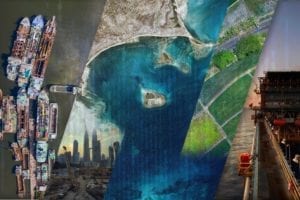
Sighting the Dark Fleet: Hyperspectral’s Role in Securing Safer Seas
The date is April 10. Iran has closed the Strait of Hormuz in retaliation to strikes by the U.S. and Israel, triggering a regional war. An infamous very large crude […]
-
 Imagery and Sensing
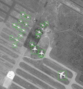
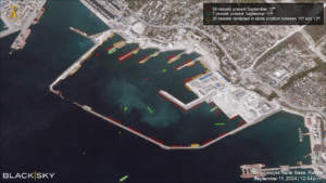
BlackSky Advances Non-Earth Imaging Business With 7-Figure Renewal
BlackSky Technology has received a large contract renewal focused on non-Earth imagery services — in which its satellites capture imagery of other objects in orbit. BlackSky said this award comes […]
-
 Imagery and Sensing
Planet is Building an Agentic Geospatial AI Query
Planet is building an agentic AI geospatial query, where users could ask a question like “Where are new construction sites appearing in Florida?” and get an answer. The agent is […]
-
 Imagery and Sensing
Amadeus IT Group to Use Spire’s Aircraft Tracking Data for Airport Management Tool
Amadeus IT Group, a travel technology provider that supports airlines and airports, will integrate Spire Global’s aviation intelligence and data into its cloud platform used in airport operations. Under a […]
-
 Imagery and Sensing
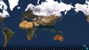
Iceye Launches New Solution for Banking Sector
Iceye is targeting the international banking sector with a key new launch. It is bringing to market natural catastrophe monitoring solutions designed for the global banking sector. The offering will […]
-
 Imagery and Sensing
Greek Government Taps Planet for New Satellite Data Deal
Planet Labs Germany has won a significant new contract with a major government in Europe. The Greek government has signed a 2-year, 7-figure agreement with Planet that will include numerous […]
-
 Opinion
Operational AI is Hitting the Limits of Earth Observation Data
AI is entering a different phase in Earth Observation. What began as experimentation on curated datasets is now moving into operational use, where models are expected to keep working across […]
-
 Imagery and Sensing
Enabled by AI, NGA Director Focused on Mission, Transformation, and Workforce
AURORA, Colo. — To ensure the National Geospatial-Intelligence Agency (NGA) is postured to meet rapidly evolving threat and warfighters’ needs, is resilient and exploits emerging technologies, the agency’s new director […]
-
 Imagery and Sensing
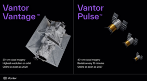
Vantor Introduces New Satellite Classes for High Resolution Imaging, Frequent Revisits
Commercial satellite operator and spatial intelligence provider Vantor on Thursday introduced two new classes of electro-optical imaging satellites that packaged together offer its customers high-resolution imagery and frequent revisit rates around the […]
-
 Imagery and Sensing
Italy and Argentina to Enhance Space Collaboration With Telespazio and VENG Deal
Italy and Argentina are to continue their collaboration in the space data arena. e-GEOS, a joint venture between the Italian Space Agency and Telespazio, has signed a multi-year co-operation deal with […]
-
 Imagery and Sensing
Planet Details AI-Driven Object Detection Onboard Pelican-4 Satellite
Planet recently performed AI-driven object detection directly onboard a Pelican-4 satellite, using the satellite’s onboard Nvidia Jetson Orin module. Planet shared details on Tuesday of the recent tech milestone. On […]
-
 Imagery and Sensing
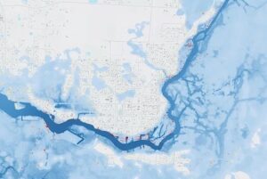
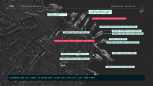
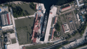
How Iceye Satellites Track Russian Vessels, Illegal Shipping in the Arctic
On a dark, clouded night, a Russian ballistic missile submarine departs a naval base in the Arctic. A small vessel navigates the Mediterranean Sea at 15 miles per hour. A […]
-
 Imagery and Sensing
Satellogic Plans Next-Gen Merlin EO Constellation
Satellogic detailed plans for its next-generation ‘Merlin’ satellites, designed to provide one-meter resolution. The company said that Merlin will be differentiated by its ability to provide daily mapping of the […]
-
 Imagery and Sensing
Airmo Earns 5 Million Euro in Seed Funding, Plans First Launch for 2027
German tech startup Airmo has raised €5 million (~$5.8 million) in its seed round of funding, the company announced on Thursday. Airmo markets a proprietary sensor for detecting methane leaks […]
-
 Government/Military
NGA Awards BlackSky Seven-Figure Order on Luno A Contract
BlackSky has won a seven-figure renewal deal with the National Geospatial Intelligence Agency (NGA). It has secured this award under the company’s NGA Luno A Facility Monitoring Delivery Order. According […]
-
 Finance
HawkEye 360 Adds $23M to Series E Funding
HawkEye 360 has raised a further $23 million to its Series E funding round, with participation from new investors Ghisallo, Principia Growth, and Sixty Degree Capital. Existing investor Strategic Development […]
-
 Finance
BlackSky’s Growth Contracts in 2025 for Second Year
BlackSky’s 2025 financial performance was a mixed bag, with an increase in fourth quarter revenue and a 32% increase in backlog, despite an increase in the company’s net loss and […]
-
 Imagery and Sensing
Airmo Selects EnduroSat to Launch Methane-Monitoring Sensors into Orbit
Germany and Luxembourg-based sensing company Airmo will partner with satellite manufacturer EnduroSat to put its methane emissions monitoring technology into orbit, with the first satellite of a projected 12-satellite constellation […]
-
 Imagery and Sensing
Axelspace and Synspective Lock In Imagery Contracts for Japanese Constellation
Japanese satellite imagery providers Axelspace and Synspective finalized agreements with SKY Perfect JSAT, Mitsui, and Mitsubishi Electric to provide optical and synthetic aperture radar (SAR) imagery respectively to the Japan […]
-
 Imagery and Sensing
Loft Orbital, SmartSat CRC to Demonstrate Wildfire Detection Technology
Loft Orbital is partnering with SmartSat Cooperative Research Center to demonstrate an AI-powered wildfire detection software on its satellites, the hosted payload operator announced on Wednesday. The mission is meant […]
-
 Imagery and Sensing
BlackSky International Customer Orders Gen-3 Satellite for Sovereign Access
BlackSky Technology announced a deal with an unnamed international customer for a dedicated Gen-3 satellite, along with BlackSky’s imagery and analytics services. The deal announced Tuesday will give BlackSky’s international […]
-
 Imagery and Sensing
Planet and AXA Partner for AI-Powered Risk Management Platform
Planet Labs’ German subsidiary is partnering with a new arm of insurance firm AXA to integrate its Earth Observation data into an AI-powered risk management system to monitor and predict […]