
Imagery and Sensing
-
 Finance
BlackSky Promotes Imagery Industry Veteran to CFO
BlackSky Technology has named its new CFO. The geospatial intelligence company announced June 16 that it promoted Chief Development Officer Henry Dubois, a veteran of the satellite imagery industry, to […]
-
 Imagery and Sensing
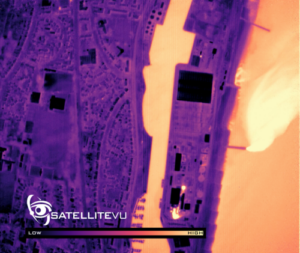
Satellite Vu to Provide Satellite Data to UK Real Estate Market with Landmark Innovation Group
U.K.-based Satellite Vu will provide climate change data from its thermal monitoring satellites to the United Kingdom real estate market through a partnership with Landmark Information Group. Satellite Vu and […]
-
 Imagery and Sensing
Inmarsat Tests Signals for United Kingdom PNT System
A team of U.K. companies led by Inmarsat has broadcast a satellite navigation signal in a project to explore a United Kingdom sovereign positioning, navigation and timing (PNT) system. Inmarsat […]
-
 Government/Military
Eumetsat’s Meteosat-9 Takes over Coverage from Meteosat-8
Eumetsat announced Wednesday that Meteosat-9 is taking over for Meteosat-8 as the prime satellite offering Indian Ocean Data Coverage (IODC) service. Eumetsat is the European Organisation for the Exploitation of […]
-
 Government/Military
Navy To Experiment With Satellite RF Sensing Data From Kleos
Kleos Space Inc. on Monday said they have entered into a research and development agreement with the U.S. Navy for an experimentation effort that will use radio frequency (RF) sensing […]
-
 Finance
SatSure Acquires Old City Innovations to Enter US Geospatial Market
Space data and analytics company SatSure has acquired Philadelphia-based geospatial services company Old City Innovations in a bid to enter the U.S. market. Old City Innovations (OCI), formerly Geospoc LLC, […]
-
 Opinion
How Space Tech Can Play a Role in Methane Detection to Impact Climate Change
ESG (environmental, social and governance) investing has become mainstream and is now estimated to account for more than one third of the $51 trillion of U.S. assets under management. The […]
-
 Government/Military
NRO Awards Imagery Contracts to Maxar, BlackSky, and Planet Worth Billions
The National Reconnaissance Office (NRO) awarded contracts to Maxar Technologies, BlackSky, and Planet, for satellite imagery worth billions of dollars over the next 10 years. The NRO said the awards […]
-
 Imagery and Sensing
TCOM Subcontracts Spire Global for Weather Forecasts at Aerostat Sites
Spire Global has received a five-year, multimillion-dollar award to provide weather forecasts for TCOM, an intelligence, surveillance, and reconnaissance (ISR) firm based in the United States. The subcontract will provide […]
-
Imagery and Sensing
NASA, ESA, and JAXA Expand Earth Observing Dashboard to Include Environmental Data
NASA announced Thursday that it reached an agreement with the European Space Agency (ESA) and the Japan Aerospace Exploration Agency (JAXA) to expand the Earth-observing satellite data sharing agreement the […]
-
 Government/Military
PredaSAR Receives DARPA Prototype SAR Contract
Terran Orbital subsidiary PredaSAR received a prototype contract award from the Defense Advanced Research Projects Agency (DARPA). The contract “aims to research synthetic aperture radar (SAR) satellite formation flying concepts […]
-
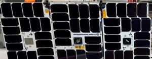
 Manufacturing
NanoAvionics to Build Three Maritime Surveillance Satellites for Kongsberg Defence & Aerospace
Norwegian company Kongsberg Defence & Aerospace has ordered three microsatellites from NanoAvionics for a space-based maritime surveillance mission. The companies announced the deal May 18, financial terms were not disclosed. […]
-
 Manufacturing
Terran Orbital Ships 2 GeoOptics Satellites to Cape Canaveral Ahead of SpaceX Launch
Terran Orbital Corporation shipped two next-generation satellites for Earth observation company GeoOptics to Cape Canaveral ahead of launch on SpaceX’s Transporter-5 rideshare mission. The Transporter-5 mission is set for May […]
-
 Government/Military
NRO Plans Solicitation for Commercial Radio Frequency Sensing
AURORA, Colo.—The National Reconnaissance Office (NRO) this summer expects to seek proposals from commercial providers of satellite-based radio frequency (RF) sensing capabilities to help it better understand how to make use […]
-
 Imagery and Sensing
Spire Adds New Weather Insights for the Maritime Industry
Spire Global is rolling out new weather solutions for the maritime industry that the company says can analyze how upcoming weather conditions affect business operations. Spire announced the new offerings […]
-
 Government/Military
Intelligence Community is Rapidly Delivering Commercial Satellite Imagery to Ukraine, NGA Official Says
AURORA, Colo.—Advances in commercial satellite imagery collection and dissemination have enabled the U.S. intelligence community to provide commercial satellite imagery to Ukraine in its war against Russian invaders in just “minutes,” […]
-
 Imagery and Sensing
Orbital Insight Adds Satellogic Imagery to its Platform
Orbital Insight will incorporate imagery it purchased from Satellogic into its own geospatial data platform, the companies announced Monday. Orbital Insight operates the self-service geospatial data GO platform, which combines […]
-
 Finance
Capella Raises $97M in Series C Round
Capella Space raised $97 million in its Series C financing round, the synthetic aperture radar (SAR) company announced on Monday. NightDragon led the round, with significant participation from existing investors […]
-
 Imagery and Sensing
Planet Says Pelican Satellites Will Offer 30-Centimeter Resolution
Planet Labs announced Thursday that its next-generation Pelican constellation will provide up to 30 cm resolution. The constellation is also designed for greater revisit rate and will and give customers […]
-
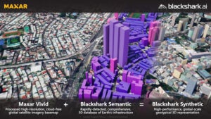 Imagery and Sensing
Maxar Invests in Blackshark.ai to Boost 3D Geospatial Offering
Maxar Technologies announced Wednesday it made a strategic investment in geospatial analytics company Blackshark.ai to boost its 3D Earth Intelligence product portfolio. Maxar said this investment combines its satellite imagery […]
-
 Imagery and Sensing
Planet Works with SynMax for Energy Intelligence and Dark Vessel Monitoring
Planet Labs is partnering with SynMax, a Houston-based satellite analytics and intelligence company, to provide energy insights and monitor dark vessel movement. SynMax founder Bill Perkins met Planet CEO and […]
-
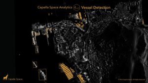 Imagery and Sensing
Capella Space Introduces New Data Products for Vessel and Change Detection
Capella Space is introducing three new analytics capabilities into its web application — vessel detection, change detection, and global change monitoring. Capella said these new products expand its self-service tasking […]
-
 Imagery and Sensing
Planet Debuts Planetary Variables Product With Soil, Temperature, and Biomass Data
Planet is launching a new product called Planetary Variables, using capabilities from the VanderSat acquisition. Planetary Variables are pre-processed data feeds that measure soil water content, land surface temperature, and […]
-
 Imagery and Sensing
Satellogic Makes Contact with Newly Launched Mark V Satellites
Satellite imagery provider Satellogic successfully launched five additional spacecraft to Sun-Synchronous Low-Earth Orbit (LEO) on Friday aboard SpaceX‘s Transporter-4 Falcon 9 rideshare mission originating from Cape Canaveral Space Force Station. […]
-
 Government/Military
Satellogic Partners with Astraea to Distribute EO Data to Ukraine
Satellogic is working with geospatial and AI analysis software company Astraea to distribute Earth observation data directly to the Ukrainian government, allied governments, and humanitarian organizations on the ground for […]
-
 Imagery and Sensing
Tomorrow.io Co-Founder Explains Backing out of SPAC, Maintains Satellite Constellation Plans
Weather intelligence company Tomorrow.io is still pursuing its plan to build a satellite constellation, despite the end of its SPAC deal, the company’s co-founder told Via Satellite. Tomorrow.io and special […]
-
 Imagery and Sensing
Spire Signs Sierra Nevada as a Space Services Customer
Spire Global has signed a space services deal with Sierra Nevada Corporation (SNC) to build four 6U Lemur satellites for SNC to conduct radio frequency (RF) collection and analysis, the […]
-
Finance
Lockheed Martin Invests in EO Startup Satellite Vu
British Earth observation (EO) startup Satellite Vu has closed the second round of its Series A, bringing total funding to 20 million pounds ($26 million). Seraphim Space Investment Trust Plc, […]
-
 Imagery and Sensing
Planet Labs Updates PlanetScope Monitoring Product For Cleaner Data
Planet Labs has launched its next-generation PlanetScope Monitoring product, which takes the product from four to eight spectral bands, designed to give customers cleaner and more consistent data. PlanetScope is […]
-
 Finance
Aurora Insights Receives Strategic Investment from Maxar
Maxar Technologies is making a strategic investment in Aurora Insight, a radio frequency (RF) data provider. Aurora announced the strategic investment on Wednesday but did not share the investment amount. […]