KARI Sees Superior Forecasting on the Horizon with Harris AMI
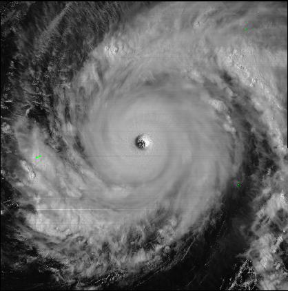
Caption: Image of Typhoon Maysak captured by the AMI on board the Himawari 8 satellite. Photo: JMA
[Via Satellite 06-03-2015] With one instrument already in orbit and several others moving toward launch, Exelis, now Harris Corp., is looking to modernize storm tracking and weather forecasting with its Advanced Meteorological Imager (AMI). The geospatial imager has most recently completed a multi-disciplinary design review for the Korea Aerospace Research Institute (KARI), which plans to launch it aboard its GEO-Kompsat 2A satellite in 2018 for a 10-year mission. The new instrument aims to replace previous Exelis-built weather imagery technology with more accurate, next generation imagers that are capable of capturing faster, more reliable and higher resolution weather data.
“[The] Korean Peninsular has been affected by severe weather and environmental phenomena such as typhoons, Asian dust and Chinese air pollution,” explains Koon-Ho Yang of KARI, who leads the development of the AMI for GEO-Kompsat 2A. “More frequent observation through GEO-Kompsat 2A satellite can detect these events at least every two minutes.”
The more frequent information, in conjunction with the Korea Meteorological Administration’s (KMA) efforts to develop 52 meteorological products to measure Convection Initiation (CI), rainfall intensity, cloud information and aerosol information, among others, can contribute the short-term forecasting and severe weather tracking for the country, according to Yang.
“This new instrument provides vast improvement in all aspects of the capabilities, so the products that are produced, the forecasts that are produced are all going to be increased significantly,” said Eric Webster, environmental intelligence vice president and director at Harris (formerly Exelis). “That will mean increased lead time for severe storms for people to take shelter or for planning, improved — in the case of the Koreans — typhoon tracking and intensity forecasts if they have to evacuate, or it can offer improvements for their emergency planning.”
The geostationary imagers responsible for collecting this information fly roughly 22,000 miles above Earth gazing at specific regions — such as South Korea or Japan — and provide constant, near real-time data to weather forecasters and the public. Exelis has already delivered one version of the instrument to the National Oceanic and Atmospheric Administration (NOAA) for launch with its Geostationary Operational Environmental Satellite-R Series (GOES-R) next generation spacecraft and to the Japan Meteorological Agency, which launched the AMI aboard the Mitsubishi Electric-built Himawari 8 weather satellite in 2014.
“These instruments that are up there are very important for severe storm forecasting or kind of your ‘now-to-24-to-48 hours’ of forecast. They’re important for hurricanes, typhoons, in the case of the Pacific, tornado activities, sever thunderstorms, etc.,” said Webster.
Harris is responsible for developing and building the last two legacy weather imaging systems that are currently flying on satellites for countries such as the United States, Japan, and Korea. The new generation instruments aim to expand and improve weather forecasting in every way, according to Webster.
“The current instruments provide five channels, bands or filters, so when it looks to the storm it can see five different characteristics, such as water vapor, humidity and pressure, etc.,” he said. “The new instrument that we’re building has 16 channels, so they have many more bands, if you will, of thermal detection and infrared detection along with the continuation of the current bands and channels. You’re going to get a more detailed view of the storm and the characteristics of what makes up that storm.”
These enhancements over previous systems include improved resolution, which will bring twice the resolution capability of South Korea’s existing satellites to about one-half mile. “The new picture of that storm will be much clearer, just like if you focus a zoom lens on your camera. That’s really important for forecasters to get more clarity and resolution,” said Webster.
The new AMI will also be able to provide data to KARI nearly five times as fast as current imagers. This means that the new instrument will be able to scan the hemisphere in five minutes time whereas before it took closer to a half hour to gather and send the information.
“This instrument will also be able to [scan] … Korea or a region, such as the United States or a larger sized area, in a much shorter time, something like two and a half minutes. It will also be able to do an individual storm, such as a typhoon, in Korea’s case, every 30 seconds,” explained Webster, noting this is a significant improvement over South Korea’s current instrument, which can provide region-specific data every seven and half minutes.
The more accurate and frequent weather info can open the door to better storm planning for the government or more time for citizens to take cover or evacuate, if necessary, in the wake of severe weather. But there are more overarching effects as well.
“Korea’s economy, just like the U.S., is heavily impacted by weather, overall, from transportation and logistics, tourism, agriculture, fishing and aviation,” said Webster. “By having a better forecast and more accurate information and data about what’s actually happening, everyone is going to benefit from that in a sense.”
The new instrument can also help improve forecasting on a number of other fronts. It can improve aviation flight route planning by offering a more dynamic forecast of the upper atmosphere, gauging water vapor and enabling volcanic ash monitoring. It also offers the capability to monitor fire protection and intensity estimation for wildfires alongside channels that will help provide air quality warnings and alerts, an issue that impacts parts of Asia due to bad air quality from China and other areas around the far east.
As it moves past the design review, Harris has begun readying the AMI for the testing phase before it is introduced to orbit aboard the KARI satellite. The company also has plans to deliver more instruments to Japan and NOAA and hinted at the possibility of new contracts for the AMI with the Canadian and U.S. governments. Although budgets pose something of an issue in North America, particularly with the U.S., the government will need to make a decision regarding its weather forecasting soon enough as previous systems begin to phase out.
“We’ve recently been briefing the United States Air Force about options for its weather program,” said Webster. “It had been relying on a European geoimager over the Indian Ocean area for military purposes. They had been getting information from a European satellite for their military planning. The Europeans aren’t going to replace that instrument, so there are discussions about whether we could build one of our geoimagers, put it on a communications satellite and put it over the Indian ocean area to provide that same kind of weather capability and coverage for the U.S. military.”