In honor of Jim Bridenstine’s confirmation to the post of NASA Administrator, I present three stories highlighting the importance and capability of satellite imagery to study and better know our planet:
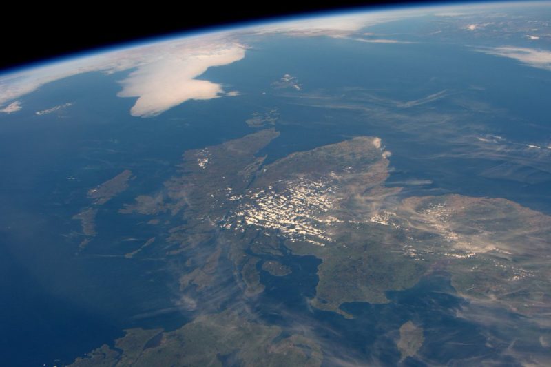
1. “A cloud-free Europe: Stunning mosaic of satellite images reveals a clear view of the continent in incredible detail”
They even managed to get a cloud-free picture of Scotland! This doesn’t happen very often: “In 2016, U.S. astronaut Jeff Williams managed to take a similarly rare photo of Scotland without clouds. “We had a great view of Scotland today … very rare to not be covered with clouds,” he tweeted. At the end of last year NASA released another image of the Scottish highlands caked in snow with lots of cloud cover, which is the view astronauts are more used to seeing. The 2017 image was taken from NASA’s Terra Satellite Earth Observing System which is the size of a minibus. For almost 18 years the Terra satellite and its five sensors have collected data about Earth and its complex systems.”
We had a great view of Scotland today…very rare to not be covered with clouds. pic.twitter.com/R31MXg2I1U
— Jeff Williams (@Astro_Jeff) August 16, 2016
2. “New NASA study may improve future river-observing satellites”
Incredibly useful information to help minimize losses from hurricanes. “Early flood warning systems traditionally depend on gauge networks that detect floods farther up the river, but gauge data are becoming more and more scarce,” said George Allen, lead author of the new research and a hydrologist at JPL. “Our study shows that there’s room for satellites to help fill in the gap. But for satellites to inform real-time flood mitigation, they have to provide data to water managers within a sufficiently short lag time.”
3. “Inshore insights: Using satellite imagery to locate clean water” (Google Earth gives anglers big advantage in finding potential fishing spots)
Two things I learned from this blog post – 1) How people who aren’t aerospace engineers or tied to the satellite industry teach other non-space affiliated audiences to use satellite applications for everyday activities. 2) From the article: “With Google Earth, you can observe how clean water is. See, clean water tends to appear darker in satellite imagery, whereas dirtier water appears to be lighter in color. If you’re still not sure, use the Mississippi River as your “go to” for what dirty water looks like, since it’s always dirty.”