
Imagery and Sensing
-
 Government/Military
Maxar Receives Study Contract with NRO
Maxar Technologies was awarded a study contract with the National Reconnaissance Office (NRO). This contract aims to help enable the U.S. government to gain a greater understanding of Maxar’s current […]
-
 Government/Military
Maxar Awarded $95 Million in US Government Contracts
Maxar Technologies revealed that it was awarded multiple contracts in the first quarter of 2019 to provide Earth intelligence solutions to U.S. government agencies, with a total value of more […]
-
 Imagery and Sensing
HawkEye 360 Provides RF Data to BlackSky
HawkEye 360 signed an agreement with BlackSky to provide Application Programming Interface (API) access to selected Radio Frequency (RF) data for customers interested in global spectrum monitoring. BlackSky intends to […]
-
 Imagery and Sensing
LandSpace, Luokung Partner on Satellite Remote Sensing
Luokung Technology, a spatial-temporal big-data processing technology company, formed a strategic partnership with LandSpace Technology. The two parties will work together, focusing on satellite remote sensing data applications as the […]
-
 Government/Military
Peraton, Harris win GOES-R Ground System Contract
The U.S. National Oceanic and Atmospheric Administration (NOAA) awarded the Geostationary Operational Environmental Satellite–R Series (GOES-R) ground system contract to Peraton and Harris Corporation. The three-year contract is valued at […]
-
 Imagery and Sensing
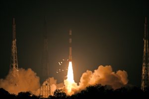
India Successfully Launches Earth Observation Satellite
India’s Polar Satellite Launch Vehicle (PSLV-C46) successfully launched its RISAT-2B Earth Observation (EO) satellite from Satish Dhawan Space Center (SDSC) on Wednesday. PSLV-C46 lifted-off at 5:30 IST from the First Launch […]
-
 Government/Military
Collins Aerospace Receives Security Certification for GPS Module
Collins Aerospace Systems, a unit of United Technologies, received the Global Positioning Systems Directorate (GPS-D) security certification from the U.S. Air Force Space and Missile Systems Center (USAF SMC) for its […]
-
 Imagery and Sensing
HawkEye 360, Windward Partner on Maritime Domain Awareness
HawkEye 360 and maritime risk analytics provider Windward partnered to offer new global insights into maritime domain awareness through their combined capabilities. HawkEye 360 will contribute its Radio Frequency (RF) dataset for […]
-
 Imagery and Sensing
HERE Technologies Renews Maxar Satellite Imagery Contract
HERE Technologies, a mapping and location platform services provider, renewed its satellite imagery contract with Maxar Technologies for the global production of HERE’s in-car navigation maps. Additionally, Maxar won the 2019 Americas […]
-
 Imagery and Sensing
China Launches BeiDou Navigation Satellite System Satellite
China launched a new satellite for the BeiDou Navigation Satellite System (BDS) from the Xichang Satellite Launch Center at 11:48 p.m. local time Friday. The satellite was launched on a Long […]
-
 Government/Military
NOAA Awards Harris Ground Segment Contract Extension
The National Oceanic and Atmospheric Administration (NOAA) awarded Harris a three-year, $284 million sole-source extension on the ground segment contract supporting Geostationary Operational Environmental Satellite (GOES) -R Series weather satellites […]
-
 Imagery and Sensing
ICEYE, APSI Provide SAR Imaging to South Korea
Asia Pacific Satellite (APSI) and ICEYE, a provider of small satellite Synthetic Aperture Radar (SAR) technology, have signed a memorandum of understanding about working together to support the South Korean […]
-
 Government/Military
Raytheon to Begin Installing GPS OCX
Raytheon‘s Global Positioning System (GPS) Next-Generation Operational Control System program, known as GPS OCX, completed final qualification testing of the system’s modernized monitor station receivers, which are now ready to […]
-
 Government/Military
MDA to Deliver Satellite Search and Rescue Repeaters for Canada
MDA, a Maxar company, was awarded an initial contract value of approximately $30 million (CAD $39 million) with Public Services and Procurement Canada. The initial contract includes the development and […]
-
 Imagery and Sensing
CGI, Thales Alenia Space Sign Contract for Galileo Security Software
CGI signed an agreement with Thales Alenia Space to enhance and maintain security software for the Galileo satellite navigation system. Valued at approximately 14 million euros ($15.71 million), the contract will […]
-
 Imagery and Sensing
Spire Global Provides AIS Data for BAE Systems Software
Spire Global will provide Automatic Identification Systems (AIS) data for BAE Systems’ Geospatial eXploitation Products (GXP) software. BAE Systems will include Spire’s data in its GXP software solutions, which offers geospatial […]
-
 Imagery and Sensing
Capella Space Uses Blue Canyon Technologies’ Attitude Control Systems
Capella Space, an information services company providing Earth Observation (EO) data on demand, will provision the first phase of its small satellite constellation with attitude control systems from Blue Canyon […]
-
 Imagery and Sensing
Airbus, Orbital Insight Expand Partnership With Earth Monitor
Airbus Defense and Space and Orbital Insight have expanded upon their partnership agreement to create Earth Monitor, a change analysis and insights service which provides situation awareness over archived or […]
-
 Imagery and Sensing
Toyota, Maxar, NTT DATA Build HD Maps for Autonomous Vehicles
Toyota Research Institute-Advanced Development (TRI-AD), Toyota’s automated driving software development company, Maxar Technologies, and NTT DATA will collaborate on a proof of concept to build automated High-Definition (HD) maps for autonomous vehicles […]
-
 Government/Military
Slingshot Aerospace Receives SSA Contract From US Air Force
The Air Force Space and Missile Systems Center (SMC) awarded Slingshot Aerospace a $6 million contract to rapidly prototype and deploy Machine Learning (ML) capabilities to augment a wide variety of Enterprise […]
-
 Imagery and Sensing
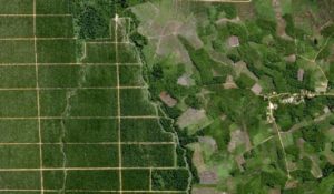
Farmers Edge Releases App-Based In-Field Intelligence Tool
Farmers Edge released an app-based in-field intelligence tool. Digitally linking growers, dealers, retailers, trusted advisors, and other stakeholders, the In-Cab Tool aims to provide visibility of every field activity while simplifying […]
-
 Imagery and Sensing
E.ON Exec: How Satellite Technology Benefits Energy Companies
U.K. energy company E.ON is an example of the new type of potential customer the satellite industry can target. The company has been using an innovative approach towards satellite as it […]
-
Finance
Slingshot Aerospace Raises $5 Million in New Seed Funding
Slingshot Aerospace, an analytics company, raised $5 million in new seed funding. The round was led by ATX Venture Partners with participation from new investor Revolution’s Rise of the Rest […]
-
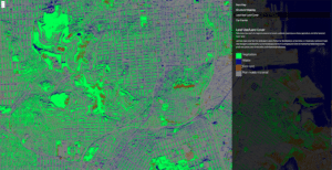
 Imagery and Sensing
Satellite Navigation: A Global Perspective
The Satellite Navigation (SatNav) market has seen tremendous growth in recent years with our constantly-connected, Google Maps-driven society contributing to a huge increase in the number of devices connected to navigation […]
-
 Imagery and Sensing
Kleos Space Offers Pre-Orders for Initial Products
Kleos Space, a space-powered Radio Frequency (RF) Reconnaissance data provider, has moved towards commercialization of its global maritime geolocation Data-as-a-Service (DaaS) products with the launch of a new website with pre-order […]
-
 Mobility
Spire Expands Reach into Maritime Chartering, Commodity Markets
Satellite data analytics firm Spire Maritime has entered into a strategic technology partnership with AXSMarine to provide enhanced maritime intelligence services for chartering and commodity markets, the companies announced April 12. […]
-
 Connectivity
Airbus Signs Another Agricultural Data Partner
Airbus Defense and Space has entered into a partnership with Bayer subsidiary The Climate Corp., to deliver its satellite-produced imagery to farmers through Climate Corp.’s Climate FieldView digital agriculture platform, the […]
-
 Imagery and Sensing
HawkEye 360 Releases 1st RF Signal Mapping Product
HawkEye 360 launched RFGeo, a first-of-its-kind radio frequency (RF) signal mapping product. RFGeo uses the data generated by the HawkEye Constellation of space-based Radio Frequency (RF) sensing satellites to identify […]
-
 Imagery and Sensing
Hughes to Work on US Army Blue Force Tracking Program
Hughes Network Systems was awarded a two-year Cooperative Research and Development Agreement (CRADA) by the U.S. Army for the third phase of the Blue Force Tracking (BFT-3) program. Under the agreement, […]
-
 Imagery and Sensing
Maxar, Vulcan Partner on Domain Awareness Systems
Maxar Technologies revealed that Vulcan signed a multi-year EarthWatch subscription, a cloud-based product for viewing, streaming, and downloading Maxar’s geospatial data. Vulcan will use this product for projects including detecting […]