
Imagery and Sensing
-
 Imagery and Sensing
Trimble Launches Farmer Core SaaS
Trimble launched Farmer Core, a new entry-level Trimble Agriculture (Ag) Software subscription that helps enable farmers to connect all aspects of their farm operation. Available online and on any mobile device, […]
-
 Imagery and Sensing
GHGSat Plans to Launch Iris Satellite This Summer
GHGSat, a private company which owns and operates a satellite for monitoring Greenhouse Gas (GHG) emissions from industrial sources, revealed that its second satellite will be known as Iris. The […]
-
 Imagery and Sensing
SSTL, OSS Work Together on Smallsat SAR Payload
Surrey Satellite Technology (SSTL) and Oxford Space Systems (OSS) have been awarded National Space Technology Program funding to develop a stowage-efficient Synthetic Aperture Radar (SAR) payload. This new technology aims […]
-
 Imagery and Sensing
Kleos, ImageSat Collaborate on Maritime Geospatial Intelligence Analytics
Kleos Space signed a collaborative, non-binding, Memorandum of Understanding (MoU) with Israeli based end-to-end geospatial intelligence company ImageSat International (iSi) to explore opportunities to use Kleos’ maritime Radio Frequency (RF) activity-based […]
-
 Imagery and Sensing
ExoAnalytic Solutions, Northstar Earth and Space Collaborate on SSA
ExoAnalytic Solutions and NorthStar Earth and Space are collaborating to develop commercial services to protect satellites and other space assets from collisions with space debris and other orbiting objects. The […]
-
 Government/Military
ORBCOMM, Maerospace Extend Canada’s AIS Contract
The Government of Canada exercised the option for another year on their contract through ORBCOMM’s Canadian partner Maerospace, a global supplier of Automatic Identification System (AIS) data and maritime domain […]
-
 Connectivity
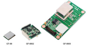
Furono Launches Single-Band GNSS Receivers
Furuno Electric, based in Nishinomiya, Japan, developed GT-88 and GF-8801/02/03/04/05 for users who require Coordinate Universal Time (UTC) time-synchronized signals to meet the new 5G requirements. They provide UTC time-synchronized timing signals (1PPS/10MHz) […]
-
 Imagery and Sensing
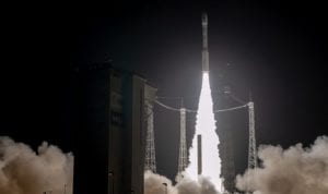
Arianespace Successfully Launches Italian Earth Observation Satellite
Arianespace successfully launched the Italian Space Agency’s Prisma satellite on a Vega rocket at 10:50 p.m. local time from the Guiana Space Center (CSG) in French Guiana. Prisma is the 600th satellite […]
-
 Connectivity
Orbital Insight Launches New Monitoring Product
Orbital Insight launched its refinery outage product, a daily data feed that detects maintenance activity changes up to three days before existing reporting services. This product aims to help energy sector […]
-
 Imagery and Sensing
Spacebel, Wuudis Solution Strengthen Forestry Service Offering
Spacebel and Wuudis Solutions signed a business agreement to strengthen their forestry services common offering. The agreement pertains to both the distribution of the Wuudis services to the forest users of […]
-
 Imagery and Sensing
Frequency Electronics to Qualify Atomic Clocks for Lockheed Martin
Frequency Electronics (FEI) received a contract from Lockheed Martin Space, valued at $5.9 million, for the qualification of FEI’s Digital Rubidium Atomic Frequency Standard (DRAFS). The contract’s intent is to qualify […]
-
 Government/Military
Team TBG Receives NOAA ProTech Oceans Contract
Team TBG was awarded a contract in support of the National Oceanic and Atmospheric Administration‘s (NOAA) Professional and Technical (ProTech) Services Oceans Domain. ProTech is a suite of contracting vehicles organized into […]
-
 Connectivity
Orbcomm Launches Solar-Powered Tracking Solution
Orbcomm launched its next generation solar-powered GT 1200 series of devices as part of a telematics solution that includes multiple sensor options, and cellular and optional satellite connectivity for trailer […]
-
 Government/Military
EASA, ANAC Approve AerTrak ADS-B on Boeing 757-200 Aircraft
AerSale, a global supplier of mid-life aircraft, revealed that the European Aviation Safety Agency (EASA) and the National Civil Aviation Agency of Brazil (ANAC) have approved the company’s AerTrak Automatic […]
-
 Government/Military
E-GEOS Heads 2 Crisis Management Projects
E-GEOS, a company set up by Telespazio and the Italian Space Agency, signed two contracts with the Joint Research Center of the European Commission and with the European Union (EU) Satellite […]
-
 Imagery and Sensing
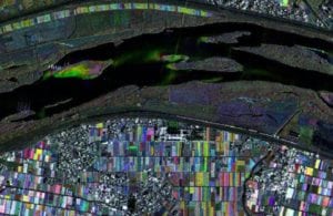
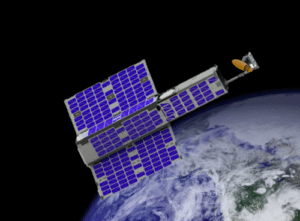
Orbital Micro Systems Delivers Satellites to NanoRacks
Orbital Micro Systems (OMS) revealed that the first satellite in its Global Environmental Monitoring System (GEMS) constellation has been delivered to NanoRacks for launch integration. Housed in an AAC Clyde […]
-
 Imagery and Sensing
DDC Carries Out Successful SBC Flight on GOSAT-2
Data Device Corporation (DDC) carried out another successful flight of its SCS750 Single Board Computer (SBC) on the Second Greenhouse Gases Observing Satellite (GOSAT-2). Mitsubishi Heavy Industries and The Japan […]
-
 Imagery and Sensing
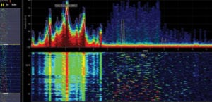
HawkEye 360 Satellites Begin RF Geolocation
HawkEye 360 commissioned its three Pathfinder satellites and began geolocating Radio Frequency (RF) signals. According to the release early test results have demonstrated successful geolocation of Very High Frequency (VHF) Channels 16 […]
-
 Connectivity
ITC Global Enters Partnership Agreement with Thuraya
ITC Global has signed a multi-year partnership agreement with Thuraya to provide access to next-generation, high-throughput connectivity via the Panasonic network. ITC Global is a subsidiary of Panasonic Avionics Corporation, delivering high-speed, […]
-
 Finance
Wireless Industry Veteran Rick Dunn Joins Satellogic as CFO
Satellogic, an integrated geospatial analytics company, appointed Rick Dunn as the company’s new Chief Financial Officer (CFO). Dunn brings over 25 years of financial experience and leadership to Satellogic, including […]
-
 Imagery and Sensing
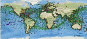
ExactEarth Completes AIS Constellation Rollout
ExactEarth completed the rollout of its real-time global satellite Automatic Identification System (AIS) service after activating the final six payloads of its exactView constellation, the company reported Feb. 15. The […]
-
 Imagery and Sensing
Capella Space Expands Team with Former Lockheed, Planet Executives
Capella Space added senior business and engineering leaders to its team. Scott Soenen was added as vice president of product engineering; Matt Wood as vice president of go-to-market and business strategy, […]
-
 Imagery and Sensing
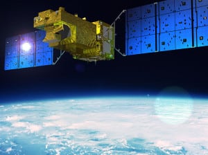
NOAA’s GOES-17 Satellite is Now Operational
GOES-17, the second of the National Oceanic and Atmospheric Administration’s (NOAA) next-generation Geostationary Orbit (GEO) weather satellites, has completed its checkout phase and is now operating in the GOES West […]
-
 Imagery and Sensing
Thales Alenia Space to Help Supply Satellite Navigation Services in Africa
The Agency for the Safety of Air Navigation in Africa and Madagascar (ASECNA) signed a contract with Thales Alenia Space on Feb. 8 in Dakar, Senegal to conduct a preliminary design […]
-
 Connectivity
IBM Uses Satellite Tech for Energy and Utility Industry
IBM unveiled new technology to reduce power outages by helping energy companies predict where trees and other vegetation may threaten power lines. IBM worked with Oncor, the largest utility company […]
-
 Imagery and Sensing
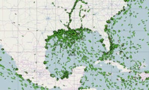
Australian Scientists Use Satellites for Drought Prediction
According to an announcement from the Australian National University (ANU), scientists used new space technology to predict droughts and increased bushfire risk, up to five months in advance. “We’ve been […]
-
 Government/Military
New MOD Investment to Fund British Deployable Satellite Antennas
A new $1.3 million (1 million British pounds) MOD investment will be funding the development of a new generation of British deployable satellite antennas. The ‘wrapped rib’ antenna aims to be […]
-
 Government/Military
Luokung Technology Enters Strategic Partnership with Chinese Engineering Center
Luokung Technology, a Chinese graphics data processing technology company, is strategically cooperating with the National Engineering Research Center for Remote Sensing Applications (the Engineering Center), which is China’s national-level center […]
-
 Imagery and Sensing
Analysts Losing Confidence in Maxar
It has not been a good start to the year for Maxar Technologies. The company revealed in the last few days that its WorldView-4 satellite (WV4) has likely suffered a […]
-
 Imagery and Sensing
Thales Alenia Space to Lead ESA’s FLEX Mission
Thales Alenia Space signed a contract with the European Space Agency (ESA) to lead the Fluorescence Explorer (FLEX) satellite mission. FLEX was selected in 2015 as ESA’s eighth Earth Explorer mission, […]