
Imagery and Sensing
-
 Imagery and Sensing
Capella Space, SpaceNet Expand Access to SAR Data
Capella Space, an information services company that provides on-demand Earth Observation (EO) imagery, is partnering with SpaceNet, a nonprofit organization dedicated to accelerating open source, Artificial Intelligence (AI) applied research […]
-
 Government/Military
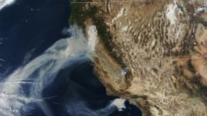
Planet, Salo Sciences, Vibrant Planet Monitor California Wildfire Risk
Planet, Salo Sciences, and Vibrant Planet partnered to develop the California Forest Observatory (CFO) — a new platform that aims to dynamically map forest structure and fuel loads down to […]
-
 Imagery and Sensing
Orbital Micro Systems Proves Commercial Viability of EO Platform
Orbital Micro Systems (OMS) revealed that data received from its payload on the IOD-1 GEMS satellite has proven the commercial viability of the company’s Earth Observation (EO) platform. OMS’ MINIRAD […]
-
 Imagery and Sensing
Luokung Technology, CRESDA Collaborate on Remote Sensing
Luokung Technology, a Chinese spatial-temporal big-data processing technology company, revealed a strategic cooperation with the China Center for Resources Satellite Data and Application (CRESDA). Luokung will provide cloud services based […]
-
 Government/Military
BAE Systems Develops ML Capabilities for DARPA
BAE Systems was awarded a Phase 2 contract to develop Machine Learning (ML) capabilities aimed to help the military gain better awareness of space scenarios for the U.S. Defense Advanced Research […]
-
 Imagery and Sensing
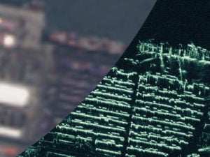
Iceye Releases Under 1 Meter Resolution SAR Satellite Imagery
Iceye, a provider of small satellite synthetic-aperture radar (SAR) technology, was the first company to achieve better than 1 meter resolution imagery from under-100 kilograms (kg) SAR satellites. The new […]
-
 Imagery and Sensing
Kleos, Spire Partner on Maritime Safety
Spire Global and Kleos Space have entered into an agreement to cooperate on creating enhanced tools for maritime safety. The companies will combine Spire Automatic Identification System (AIS) data with Kleos Radio […]
-
 Imagery and Sensing
LeoLabs Introduces Smallsat Commercial Satellite Tracking Service
LeoLabs revealed LeoTrack, a commercial satellite tracking service for smallsat and cubesat operators. LeoTrack, delivered as a web-based subscription, offers satellite operators a range of monitoring capabilities, including precision tracking of […]
-
 Imagery and Sensing
Capella Space, Addvalue, Inmarsat Partner for Real-Time Tasking
Capella Space, an information services company that provides Earth Observation (EO) data on demand, entered into an agreement with Addvalue for use of its Inter-Satellite Data Relay System (IDRS) via Inmarsat‘s […]
-
 Government/Military
NASA, NOAA Discover Cause of GOES-17 Issue
A Mishap Investigation Board appointed by NASA and the National Oceanic and Atmospheric Administration (NOAA) identified the most likely cause for an instrument issue aboard NOAA’s Geostationary Operational Environmental Satellite […]
-
 Government/Military
Operators Urge U.S. Regulators to Rethink Remote Sensing Proposal
Several U.S. satellite companies have joined together in protest of the U.S. Department of Commerce’s recently proposed rules and regulations on remote sensing. Executives from Maxar Technologies, Planet, HawkEye 360, […]
-
 Government/Military
LinQuest to Support Peraton’s NASA SENSE Contract
LinQuest will provide services as a sub to Peraton, the prime contractor of the Space Exploration Network Services and Evolution (SENSE) contract valued at up to $1.8 billion over the […]
-
 Government/Military
Airbus Runs UK C4ISR Test Center
Airbus agreed to a five-year contract with the U.K. Ministry of Defense (MOD) to manage test and reference services to support the delivery and assured release of Command, Control, Communications, Computers, […]
-
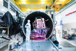 Imagery and Sensing
BEI Precision Completes Delivery for Raytheon Payload
BEI Precision Systems and Space Company delivered the Encoder/Motor Assembly for Raytheon‘s Visible Infrared Imaging Radiometer Suite (VIIRS) J4 payload. “The delivery enables Raytheon to continue the buildout of this […]
-
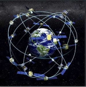
 Imagery and Sensing
Europe’s Galileo System Suffers Service Outage
Galileo, the European satellite navigation system, has been suffering a major outage since Friday, reports BBC News. The system’s status page currently lists all 22 of its satellites as either […]
-
 Imagery and Sensing
Intermap Technologies Receives $3.2 Million Task Order
Intermap Technologies received a task order for $3.2 million to provide high-resolution terrain elevation models, related imagery, multi-sensor/multi-frequency source data, and feature layer extraction for a government customer. In addition, the company will […]
-
 Government/Military
Spire, Luxembourg Space Agency Launch Data Lake
Spire Global Luxembourg will launch its open source Data Lake. The Spire Data Lake is accessible free of charge to all start-ups, research institutes, and public agencies in Luxembourg. These […]
-
Imagery and Sensing
Orbital Micro Systems, Georgia Tech Develop EO Instruments
Orbital Micro Systems (OMS) partnered with the Georgia Institute of Technology to develop Monolithic Millimeter-Wave Integrated Circuit (MMIC) devices using silicon-germanium semiconductor hybrid material for its next generation of commercial […]
-
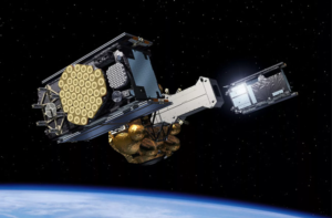
 Government/Military
Lockheed Martin’s 2nd GPS III Satellite Ready for Launch
Lockheed Martin revealed that its second, next-generation GPS III satellite is ready for its planned July 25 launch. On June 26, Lockheed Martin Space and United Launch Alliance (ULA) technicians completed […]
-
 Imagery and Sensing
Maxar Provides Satellite Imagery Products to Esri
Maxar Technologies signed a three-year contract to continue providing its Vivid and Metro satellite imagery mosaics to Esri’s ArcGIS Living Atlas of the World. This new contract builds upon Esri and […]
-
 Imagery and Sensing
China Launches 2nd BeiDou Satellite Into Inclined GEO
China launched another BeiDou Navigation Satellite System (BDS) satellite from the Xichang Satellite Launch Center in Sichuan Province at 2:09 a.m. local time on Tuesday. Launched on a Long March-3B carrier […]
-
 Government/Military
NASA Seeks Wider Use of GPS: Not From Space, but in Space
NASA, one of the U.S. government agencies that manages GPS, wants to expand the navigation system’s application in a place many probably never thought of using it — space itself. […]
-
Government/Military
Globalstar, Echo Ridge Offer GPS Backup Tech to DOT
Globalstar and Echo Ridge developed and are prepared to support a live field demonstration of a stand-alone Positioning, Navigation, and Timing (PNT) capability to backup and/or complement GPS in case of […]
-
 Imagery and Sensing
SpaceX launches Canada’s RADARSAT Satellites
SpaceX launched three RADARSAT Constellation Mission (RCM) satellites, developed by MDA for the Canadian Space Agency, aboard a SpaceX Falcon 9 rocket from the Vandenberg Air Force Base in California. According […]
-
 Finance
Orbital Insight Opens Singapore Office
Orbital Insight opened an office in Singapore. This is the company’s seventh office location, and the second dedicated sales office to open in Asia in the past 16 months. The […]
-
Imagery and Sensing
Intermap Technologies Releases Satellite Imagery Enhancement Service
Intermap Technologies released NEXTMap Orthorectification, a new satellite imagery enhancement service. Available as a cloud-based application or professional service, NEXTMap Orthorectification leverages Intermap’s worldwide, NEXTMap One Terrain Model (DTM. Pictures taken […]
-
 Connectivity
SAR Data Disruptors Partner Up
Under the terms of a new partnership agreement, Finnish satellite data services company ICEYE will provide Synthetic Aperture Radar (SAR) data to Ursa‘s energy customers in return for Ursa reselling ICEYE […]
-
 Imagery and Sensing
Mitsubishi Electric Creates Space and Sensing Division
Mitsubishi Electric launched a Space and Sensing Systems division at its Cypress, CA headquarters. The new division will sell satellite on-board equipment including solar array panels, lithium-ion batteries, and Radio Frequency […]
-
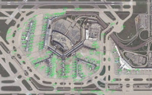 Imagery and Sensing
Lockheed Martin Develops Satellite Imagery Recognition System
Lockheed Martin developed a satellite imagery recognition system using open-source deep learning libraries to quickly identify and classify objects or targets in large areas across the world. According to the […]
-
 Imagery and Sensing
Ursa, HawkEye 360 Form Partnership
Ursa created a a strategic partnership with HawkEye 360. The companies will work together to develop new geospatial information solutions that combine Synthetic Aperture Radar (SAR) data with Radio Frequency […]