
Imagery and Sensing
-
 Imagery and Sensing
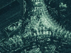
Iceye Spotlight Radar Imaging Now Commercially Available
Iceye revealed that its recently developed Spotlight imaging mode is now commercially available to its customers around the world. Iceye Spotlight imaging enables one-meter radar imaging from the company’s satellite […]
-
 Imagery and Sensing
Spire Launches AirSafe API
Spire Global revealed the company’s first product from Spire Aviation, with the launch of their new AirSafe API. Spire Aviation’s AirSafe product uses Low-Earth Orbit (LEO) Automatic Dependent Surveillance-Broadcast (ADS-B) technology […]
-
 Connectivity
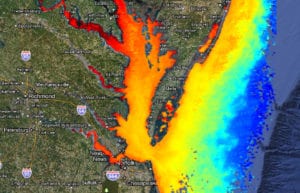
Ursa Reveals China Macro Oil Storage Indicator
Ursa launched China Macro, a new oil storage product for portfolio managers, macro funds, long-term investors and market analysts. Ursa currently uses its satellite radar technology, specifically Synthetic Aperture Radar […]
-
 Government/Military
FCC Commissioner Brendan Carr on Satellite-Powered Precision Farming
How important are precision agriculture and global food and water supply monitoring applications to our future? Via Satellite’s On Orbit podcast takes a look at the numbers: The world’s population […]
-
 Imagery and Sensing
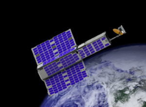
LeoLabs Reveals Kiwi Space Radar
LeoLabs launched Kiwi Space Radar (KSR) today. As the first commercial radar to track objects in Low-Earth Orbit (LEO) smaller than 10 centimeters, the KSR aims to set a new […]
-
Mobility
Qualcomm, ISRO Supports India’s Satellite Navigation System
Qualcomm Technologies is teaming up with the Indian Space Research Organization (ISRO) to support India’s Regional Navigation Satellite System (IRNSS) and Navigation with Indian Constellation (NavIC) in select chipset platforms […]
-
 Finance
Maxar to Open Facility in St. Louis
Maxar Technologies will open a new facility in St. Louis, Missouri, to support growth in several U.S. National Geospatial-Intelligence Agency (NGA) programs. The facility will be located in the Globe […]
-
 Imagery and Sensing
EOS Data Analytics Develops SAR Microsatellite Constellation
EOS Data Analytics (EOS), a space portfolio company of Noosphere Ventures, unveiled EOS SAR — a project to develop its own Synthetic Aperture Radar (SAR) sensors intended for deployment in […]
-
 Mobility
Pottle’s Transportation Selects Orbcomm for Trailer Monitoring Solution
Orbcomm, a global provider of Machine-to-Machine (M2M) and Internet of Things (IoT) solutions, was selected by Pottle’s Transportation to provide its trailer monitoring solution for their dry van fleet. Orbcomm’s […]
-
 Government/Military
NASA Ocean-Monitoring Satellite Mission Ends
The Jason-2/Ocean Surface Topography Mission (OSTM), the third in a U.S.-European series of satellite missions designed to measure sea surface height, successfully ended its science mission on Oct. 1. NASA […]
-
 Imagery and Sensing
Raytheon Completes GPS OCX Design and Development
Raytheon‘s GPS Next-Generation Operational Control System, known as GPS OCX, completed full software and hardware development and entered the system integration and test phase. The milestone keeps GPS OCX, the […]
-
 Government/Military
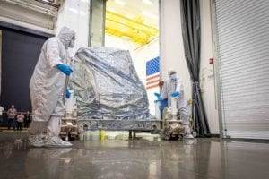
Ball Delivers Earth Science Instrument for Landsat 9
Ball Aerospace delivered the Operational Land Imager 2 (OLI-2) for Landsat 9, completing development of the instrument on schedule and under budget. Ball will continue to support instrument integration and […]
-
 Government/Military
NASA’s PUNCH Mission Enters Next Phase
Southwest Research Institute-led The Polarimeter to Unify the Corona and Heliosphere (PUNCH) mission entered Phase B, which marks the transition from concept study to preliminary flight design. The mission is […]
-
 Imagery and Sensing
KSAT, Iceye Extend Partnership for SAR Data Services
Iceye and Kongsberg Satellite Services (KSAT) signed an extended cooperation agreement to provide Near Real-Time (NRT) Synthetic Aperture Radar (SAR) data services for government and commercial customers. The newly signed […]
-
 Finance
Spire’s Receives More Than $40 Million in New Funding
Spire Global received more than $40 million in new funding from strategic partners including ITOCHU, Mitsui, and Scottish Investment Bank and financial investors led by the GPO Fund, Perennial Value […]
-
 Imagery and Sensing
Orbital Micro Systems Opens the International Center for Earth Data
Orbital Micro Systems (OMS) opened the International Center for Earth Data (ICED) at the University of Edinburgh in Scotland. A collaborative project between OMS, the University of Edinburgh, and the […]
-
 Imagery and Sensing
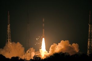
China Launches 5 Remote Sensing Satellites
Five new remote-sensing satellites were launched on a Long March-11 rocket from the Jiuquan Satellite Launch Center in northwest China’s Gobi Desert on Thursday at 2:42 p.m. Beijing Time. The […]
-
 Imagery and Sensing
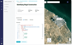
Airbus Subsidiary UP42 Launches Data and Analytics Platform
UP42, a subsidiary of Airbus Defence and Space, formally launched its commercial data and analytics platform and marketplace. UP42 opens up access for the first time to geodata and processing […]
-
 Imagery and Sensing
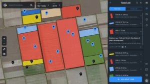
EOS Launches Digital Agriculture Platform
EOS Earth Observing System, a retailer for remote sensing satellite data, launched its digital agriculture platform — EOS Crop Monitoring — for the North American market. It combines Artificial Intelligence […]
-
 Imagery and Sensing
Capella Space Is Using SAR to Save Our Environment
It’s frustrating for environmental scientists to watch politicians mangle and regurgitate climate change data into stump campaign speeches. When Capella Space CEO Payam Banazadeh co-founded the San Francisco-based satellite constellation […]
-
 Connectivity
US Farmers Seek Enhanced Satellite Data to Meet Crop Demand
Thanks to GPS satellite-guided tractors, a single U.S. farmer can now feed 165 people each year, compared to just 10 people a few years earlier, according to U.S. Senator Joni […]
-
Imagery and Sensing
Spire Launches Spire Forecast
Spire revealed the first product from Spire Weather. Spire’s new maritime weather product, Spire Forecast, will launch today and offer new weather forecasts dedicated to the maritime industry. The product […]
-
 Imagery and Sensing
Spire Now Collecting 5000 Radio Occultation Profiles per Day
Spire Global revealed that it is now collecting 5,000 Radio Occultation (RO) profiles per day, tripling the global availability of this data. Praised for its accuracy and impact, RO data augments […]
-
 Government/Military
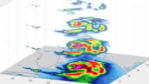
NASA CubeSat Captures 3D Imagine Inside Hurricane Dorian
We’ve seen Hurricane Dorian from inside the eye, from satellites and looking down from the International Space Station. A tiny experimental NASA weather satellite has now given us a fascinating […]
-
 Imagery and Sensing
SSTL Releases Raspberry Pi Camera Image and Video
Surrey Satellite Technology (SSTL) today released an image and video of the Earth captured from Low-Earth Orbit (LOE) by a commercial grade Raspberry Pi camera and computer on board a Demonstration […]
-
 Imagery and Sensing
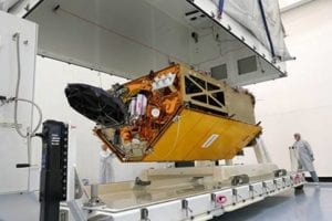
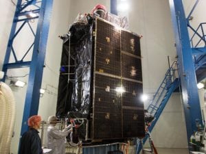
Airbus Completes Ocean Imagery Satellite
Airbus completed the ocean satellite Copernicus Sentinel-6A, and is now sending it on its first journey. Its destination is Ottobrunn near Munich in Germany, where over the next six months the […]
-
 Imagery and Sensing
ISRO’s Next-Gen Cartography Satellite Gets New Launch Date
The Indian Space Research Organization’s (ISRO) Cartosat-3 cartography satellite, originally scheduled to launch in May 2019, will now be launched toward the end of the year in October or early November, according […]
-
 Government/Military
Raytheon will Build NASA’s First GEO Hyperspectral Imager
Raytheon has been contracted by The University of New Hampshire to build the Geostationary Littoral Imaging and Monitoring Radiometer (GLIMR) sensor that will serve as NASA’s first hyperspectral imager in […]
-
 Finance
CropX Appoints New President, Closes $10 Million in Funding
In-soil agriculture analytics company CropX welcomed John Vikupitz to its executive team as president. Vikupitz will help drive the company’s global expansion with a focus on accelerating market adoption of the […]
-
 Government/Military
ULA Set to Launch 2nd GPS III Satellite for US Air Force
A United Launch Alliance (ULA) Delta IV rocket is in final preparations to launch the second Global Positioning System III (GPS III) satellite, nicknamed Magellan, for the U.S. Air Force […]