
Imagery and Sensing
-
 Finance
PNT Startup Xona Space Systems Raises $1M in Pre-Seed
Xona Space Systems, a startup working on a secure and precise Position, Navigation, and Timing (PNT) satellite service, has raised a $1 million in a pre-seed round led by 1517, […]
-
 Government/Military
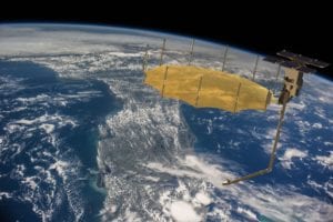
Capella Space Signs SAR Data Contract with U.S. Navy
Capella Space has signed a contract with the U.S. Department of Defense (DoD) to provide Synthetic Aperture Radar (SAR) data to the U.S. Navy, through the Defense Innovation Unit’s Commercial […]
-
 Imagery and Sensing
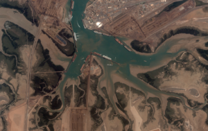
ICEYE Demonstrates New SAR Interferometry Capability
ICEYE has demonstrated interferometric capabilities from Synthetic Aperture Radar (SAR) satellites under 100 kg in mass, saying it is the first to do so. With an actively maintained 18-day ground […]
-
 Imagery and Sensing
Lockheed Martin Joins GPS Innovation Alliance
The GPS Innovation Alliance (GPSIA) has announced Lockheed Martin as the newest member of the organization. Lockheed Martin joins member companies John Deere, Garmin, Trimble, and Collins Aerospace as well […]
-
 Connectivity
SatSure, Songhai Labs Parter for Agriculture Tech in Africa
Cameroon-based Songhai Labs and Switzerland-based SatSure have partnered to launch a platform to fuel innovation in African agriculture and agtech markets, the companies announced on April 25. Songhai Labs, a […]
-
 Imagery and Sensing
BlackSky On-Demand Supports Remote Intelligence During Pandemic
BlackSky has responded to the remote work situation that many are experiencing during the coronavirus pandemic by releasing the Spectra On-Demand Secure Bundle, which intelligence analyst can use to securely […]
-
 Imagery and Sensing
Airbus to Develop Instrument for Climate Monitoring Satellite
Airbus Defence and Space will develop and manufacture the thermal infrared instrument for the TRISHNA climate monitoring satellite for the French Space Agency (CNES), the organizations announced Monday. TRISHNA, (Thermal […]
-
 Government/Military
Orbital Insight to Receive US Air Force Contract
Orbital Insight has been tentatively awarded a contract with the U.S. Air Force (USAF) to help detect anomalies around the world using Artificial Intelligence (AI) and geospatial data. The contract, […]
-
 Government/Military
NASA Expands Imagery Contract With Planet
NASA has expanded its subscription with Planet Labs and will provide the company’s Earth Observation (EO) imagery to all NASA-funded Earth science research programs, Planet announced on Thursday. This decision […]
-
 Imagery and Sensing
Rocket Lab to Launch SAR Satellite for Japanese Startup Synspective
Rocket Lab has signed a deal with Japanese satellite company Synspective to launch its first satellite, the companies announced Tuesday. Rocket plans to launch Synspective’s StriX-α Synthetic Aperture Radar (SAR) […]
-
 Finance
Atlas AI Raises $7M in Series A Round Led by Airbus Ventures
Atlas AI, a geospatial intelligence company, has raised $7 million its Series A round led by Airbus Ventures, with participation from Micron Technology and existing investor The Rockefeller Foundation. Also […]
-
 Government/Military
US Space Force Delays GPS III Launch in Response to COVID-19
The third GPS III satellite launch will take place in late June at the earliest, two months later than scheduled, to minimize the potential of COVID-19 exposure to personnel, the […]
-
 Finance
Iceye CEO Looks to Solve Problems with SAR Data
Finnish startup Iceye has big ambitions — the smallsat company wants to do for satellite imagery what IBM did for computing in the ‘80s. “We want to democratize the technology, […]
-
 Imagery and Sensing
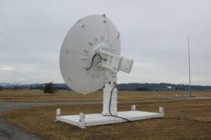
Orbit Communication Systems Receives Follow-on Ground Station Order
Orbit Communication Systems Ltd. has received a new order for a multi-band Gaia 5.5 m Gaia ground station. The high-gain dual S/X-band system will be installed in 2020. Orbit said […]
-
 Imagery and Sensing
Iceye Unveils 25-Centimeter Resolution SAR Imaging Offering
Iceye has unveiled capability of 25 cm resolution imaging with the company’s current commercial Synthetic Aperture Radar (SAR) small satellite constellation of three in-orbit spacecraft. The Finnish company said its […]
-
 Imagery and Sensing
GHGSat Supplies Bloomberg With Risk Data Informed By Satellite
GHGSat is supplying Bloomberg its methane emissions risk predictions data for the Permian Basin in the southwestern United States, the company announced Wednesday. The risk index is calculated using GHGSat’s […]
-
 Imagery and Sensing
Planet Forms Enterprise Partnership with Seisan
Planet has entered into a partnership with Seisan, a custom software solutions and systems integration company specializing in geospatial technologies, to help the data imaging satellite operator expand into new […]
-
 Imagery and Sensing
Capella, Rocket Lab to Launch SAR Satellite to Mid-Inclination
Capella Space has signed a deal with Rocket Lab to launch one of the Synthetic Aperture Radar (SAR) satellites in its Whitney Constellation, calling it the first-ever SAR satellite to […]
-
 Imagery and Sensing
Sen Selects NanoAvionics to Build Video Nano-Satellites
Sen, a British space company working to provide real-time Ultra-High Definition (UHD) video of Earth, has signed a multi-million euro contract with NanoAvionics to build the first five nano-satellites of […]
-
 Finance
PredaSAR Lands $25M Financing, Appoints Retired Air Force General to CEO
PredaSAR Corporation, a Synthetic Aperture Radar (SAR) company, has completed a $25 million seed financing round, led by Miami-based investor, Rokk3r Fuel. PredaSAR also named retired U.S. Air Force Maj. […]
-
 Government/Military
GPS Alliance Welcomes Executive Order on PNT
President Trump issued an executive order Wednesday that the federal government will take steps to ensure that Positioning, Navigation and Timing (PNT) services like GPS are not disrupted or manipulated, […]
-
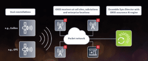 Imagery and Sensing
ADVA AI Solution Tackles GNSS Jamming
ADVA has launched a centralized GNSS monitoring and assurance tool that uses Artificial Intelligence (AI) and Machine Learning (ML) for comprehensive predictive maintenance. ADVA said the customer-owned tool enables users […]
-
 Government/Military
Lockheed Martin Delivers GPS III Satellite Ahead of April Launch
Lockheed Martin has delivered its third next-generation GPS III satellite to the U.S. Space Force ahead of an expected April launch. Last week, Lockheed Martin shipped the GPS III space […]
-
 Imagery and Sensing
Sourcewater Unveils DirtWork Alert Satellite Intelligence
Sourcewater, a digital platform for oilfield water intelligence, has debuted DirtWork Alert, which enables Sourcewater clients to see new Permian Basin oilfield development on the ground as soon as it […]
-
 Imagery and Sensing
Labsphere Developing Combined Satellite, Airborne Remote Sensing Network
Labsphere has begun constructing a commercial global satellite and airborne calibration network called FLARE. The company is combining Raytheon’s SPARC mirror technology, which it licenses, with its own technology in […]
-
 Imagery and Sensing
GHGSat Plans Free Version of its Greenhouse Gas Visualizations
GHGSat plans to deploy a free, online service that visualizes greenhouse gas emissions this year. The company said it plans to deploy the service during the United Nations‘ 2020 United […]
-
 Finance
Capella Space CEO is Ready to Bring SAR Data to the Masses in 2020
This year, Capella Space is making the transition from building its technology and business case to commercial operations, as it begins to launch its constellation of Synthetic Aperture Radar (SAR) […]
-
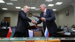 Imagery and Sensing
Belarus, Roscosmos Plan to Expand Orbital Satellite Group
The National Academy of Sciences of Belarus and Russia’s Roscosmos State Corporation have agreed to expand the joint orbital group of satellites involved in remote sensing of Earth, according to […]
-
 Imagery and Sensing
Descartes Labs Releases Cloud-Based Geospatial Analytics Platform
Descartes Labs, a New Mexico-based geospatial analytics company has deployed Descartes Labs Platform, calling it the industry’s first-ever cloud-based geospatial analytics platform. The platform provides enterprises with a real-time geospatial […]
-
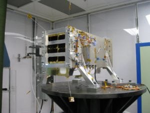
Imagery and Sensing
Capella Unveils Design for its Sequoia SAR Satellite
Capella Space unveiled on Tuesday the features of its “Sequoia” Synthetic Aperture Radar (SAR) satellite designed for on-demand Earth observation. The satellite is a re-engineering of Capella’s test satellite Denali, […]