
Imagery and Sensing
-
 Government/Military
BAE Systems Joins The GPS Innovation Alliance
The GPS Innovation Alliance (GPSIA) revealed on Monday that BAE Systems is the newest member of the organization. BAE Systems will work with GPSIA to support its goal of enhancing […]
-
 Connectivity
SpaceX Launches Starlink Batch with BlackSky Sats Along for the Ride
SpaceX launched a batch of 57 Starlink satellites with two BlackSky Earth Observation (EO) satellites along for the ride on Friday, August 7 at 1:12 a.m. EDT from Launch Complex […]
-
 Government/Military
Earth Observant Receives US Air Force Contract for VLEO Payload
The U.S. Air Force awarded Earth Observant Inc. (EOI) a contract to develop a Very Low-Earth Orbit (VLEO) optical payload. Earth Observant received this award under the under the Pentagon’s […]
-
 Imagery and Sensing
Spirent Releases SimIQ Software Enhancement for GNSS Systems
Spirent Communications on Thursday released SimIQ, a new software to allow earlier and more efficient Global Navigation Satellite System (GNSS) testing during product development. SimIQ aims to help developers collaborate […]
-
 Government/Military
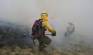
Globalstar’s SPOT Gen3 Satellite Helps Firefighters in Spain
Globalstar Europe Satellite Services has revealed details of a key new deployment of its technology in Spain. The company announced Aug. 6 that its 550 SPOT Gen3 satellite enabled safety […]
-
 Imagery and Sensing
From Amazon Software to Space-Based Blockchain with Aravind Ravichandran
Aravind Ravichandran is a Senior Strategy Consultant at PwC’s space practice, and a self-proclaimed Earth Observation (EO) data aficionado with a passion for blockchain. He sees EO as just another […]
-
 Government/Military
Viasat Reveals New Dynamic Video Encoding Capability for ISR Missions
Viasat is rolling out a new Dynamic Video Encoding (DVE) capability that optimizes sensor data for military aircraft on Intelligence, Surveillance, and Reconnaissance (ISR) missions. The new DVE capability helps […]
-
 Imagery and Sensing
LeoLabs to Build Space Radar in Costa Rica
LeoLabs, a commercial provider of Low-Earth Orbit (LEO) mapping and Space Situational Awareness (SSA) services, revealed that its next space radar will be located in Costa Rica. According to a […]
-
 Government/Military
U.S. Air Force Selects BlackSky for Real-Time COVID-19 Monitoring Data
The U.S. Air Force and the U.S. Air Force Research Lab have awarded geospatial intelligence analytics company BlackSky a contract to monitor COVID-19 mitigation efforts involving U.S. military bases and […]
-
 Imagery and Sensing
Teledyne Wins Infrared, Imagery Sensor Tech Orders for Two ESA Copernicus Missions
The European Space Agency (ESA) selected Teledyne‘s e2v business unit to supply infrared detectors and imagery sensor technology for two ESA-funded Copernicus Sentinel satellite missions. Teledyne will supply infrared detectors […]
-
 Imagery and Sensing
Planet Expands Partnership With Esri
Planet has signed a reseller agreement with its partner in Geographic Information System (GIS) software, Esri. Planet announced Monday that Esri will be reselling satellite imagery, extending access to Planet’s […]
-
 Imagery and Sensing
Intermap Technologies Partners With Zipline for African Medical Operations
Intermap Technologies revealed a new contract with Zipline to deliver geospatial Elevation-as-a-Service to support their expanding medical operations in Africa, including on-demand emergency response to COVID-19 outbreaks. The subscription contract […]
-
 Government/Military
ESA Selects Airbus for Copernicus Project
The European Space Agency (ESA) has selected Airbus Defence and Space for major Copernicus environment missions, the agency announced Wednesday. Copernicus is the biggest provider of Earth Observation (EO) data […]
-
 Government/Military
Ball Aerospace Inks Four NOAA Weather, EO Concept Study Contracts
The National Oceanic and Atmospheric Administration (NOAA) issued four, six-month contracts to Ball Aerospace for studies related to mission, spacecraft, and instrument concepts for future operational weather architectures and Earth […]
-
 Imagery and Sensing
Indigenous Companies Open Viasat Ground Station in Central Australia
Viasat Inc. and Indigenous companies in Australia’s Northern Territory have opened a ground station facility in Alice Springs. The facility was built, project-managed, and owned by Indigenous companies, the Centre […]
-
 Government/Military
PredaSAR Looks to Corner SAR Data Market with Purpose-Built Constellation
PredaSAR is working to build a constellation of 48 Synthetic Aperture Radar (SAR) satellites, and the company’s Executive Chairman and Co-Founder Marc Bell said the Earth Observation (EO) startup will […]
-
 Imagery and Sensing
SpaceX Launches Third GPS III Satellite for US Space Force
A SpaceX Falcon 9 rocket launched the newest GPS III satellite, Space Vehicle 03 (SV03), for the U.S. Space Force (USSF) from Cape Canaveral Space Launch Complex-40 in Florida on […]
-
 Government/Military
L3Harris Wins 4 NOAA Study Contracts for Future Satellite Constellation
The National Oceanic and Atmospheric Administration (NOAA) has selected L3Harris Technologies to conduct four studies on the agency’s next generation of Earth Observation (EO) satellite architecture. The studies will assess […]
-
 Government/Military
Industry Groups Launch Coalition Against FCC Ligado Order
Five industry groups have joined protests against the FCC’s approval of Ligado’s L-band network plan in April. The group, Keep GPS Working Coalition was founded by the Association of Equipment […]
-
 Government/Military
US NGA Signs Research and Development Agreement with Capella Space
Capella Space signed a Cooperative Research and Development Agreement (CRADA) with the U.S. National Geospatial-Intelligence Agency (NGA). The CRADA gives Capella access to NGA researchers for deeper insight into problems […]
-
 Finance
Maxar To Acquire Full Stake In Satellite 3D Imagery Company Vricon
Maxar Technologies has agreed to acquire Saab’s share of the two companies’ joint venture Vricon, Inc., in a $140 million cash deal. Maxar’s Tuesday evening announcement said this will allow […]
-
Imagery and Sensing
PredarSAR Plans for Constellation of 48 SAR Satellites
PredaSAR Corporation plans to launch a constellation of 48 commercial Synthetic Aperture Radar (SAR) satellites across multiple orbits to service government and commercial clients, the company announced June 18. PredarSAR […]
-
 Government/Military
Maxar Wins Government Contract for Vehicle-Tracking Analytics System
Maxar Technologies today announced that it was selected by the U.S. Department of Homeland Security (DHS) to develop an analytics system for characterizing and tracking the behavior of vehicles in […]
-
 Connectivity
SpaceX Launches Planet SkySats 16-18, Starts Taking Applications for Starlink Beta Tests
SpaceX successfully lofted three high-resolution imaging SkySats from Planet and a batch of its own Starlink communications satellites on a Falcon 9 rocket this past weekend on June 13. The […]
-
 Imagery and Sensing
US Space Force Completes GPS III SV-08 Core Mate, Names Vehicle After Katherine Johnson
The U.S. Space Force’s Space and Missile Systems Center’s (SMC) Global Positioning System (GPS) III program reached a major milestone with the successful core mate of GPS III Space Vehicle […]
-
 Imagery and Sensing
Planet Pushes Higher Resolution Capabilities, Rolls Out New User Interface
Planet has enhanced the spatial resolution of its SkySat imagery from 80 cm to 50 cm, after lowering its SkySat constellation over a time period of six months. The Earth […]
-
 Government/Military
DOD Gives Northrop Grumman $7M Modification for DMSP Contract
The U.S. Department of Defense (DoD) has awarded Northrop Grumman Systems a $7,304,322 firm-fixed-price and cost-reimbursement modification to its contract for Defense Meteorological Satellite Program (DMSP) sensor sustainment. The DMSP has […]
-
 Government/Military
Once Launched, Kleos Space Will Provide Data to Micro-Satellite Military Utility Project
Luxembourg-based data-as-a-service company Kleos Space has been contracted to provide Radio Frequency (RF) geolocation intelligence data to the Utah State University Space Dynamics Laboratory‘s (SDL) Micro-Satellite Military Utility (MSMU) project […]
-
 Imagery and Sensing
Commerce Department Issues Regulation Changes to Support Remote Sensing
The U.S. Department of Commerce released new regulations on Tuesday that are intended to improve the licensing process for private U.S. satellite remote sensing operations, in order to increase openness […]
-
 Finance
Regulus Cyber Raises $4M in Series B Round
Regulus Cyber, which offers cyber security for Positioning, Navigation, and Timing (PNT), has raised $4 million in a future Series B Round. In a Monday announcement, the Israeli-based company said […]