
Imagery and Sensing
-
 Imagery and Sensing
IHI Orders Satellites from Iceye in Deal to Assemble Satellites in Japan
Japanese aerospace and defense company IHI Corporation has signed a procurement contract with Iceye to build four satellites and up to 20 additional satellites in a synthetic aperture radar (SAR) […]
-
 Imagery and Sensing
Space42 Completes First UAE-Integrated SAR Satellites in Iceye Partnership
Space42 has shipped three synthetic aperture radar (SAR) satellites — its first satellites to go through assembly, integration, and testing (AIT) within the United Arab Emirates under a partnership with […]
-
 Imagery and Sensing
Defense Continues to Propel Earth Observation Market, With Opportunties in AI and Golden Dome
Defense continues to drive momentum in the Earth Observation (EO) satellite market, with industry leaders pointing to demand for sovereign capabilities. Novaspace Principal Annekatrien Debien, recently shared at World Space […]
-
 Imagery and Sensing
Planet Unveils Next-Gen Owl Satellites With 1 Meter Resolution, Nvidia GPUs
Planet unveiled its next-generation “Owl” satellites, which are designed to provide near-daily monitoring in 1-meter resolution, with more advanced onboard processing capabilities. The Owl fleet will provide continuity with the […]
-
 Imagery and Sensing
Sepentrio And Xona Space Systems to Collaborate on Positioning Technology
Sepentrio and Xona Space Systems have signed a new MoU as the two companies look to deepen their collaboration on next-generation positioning and timing solutions. It is an interesting partnership […]
-
 Government/Military
Planet Wins Contract Renewal to Support US Navy SeaVision Platform
The U.S. Navy awarded Planet a $7.5 million contract renewal for vessel detection and monitoring over the Pacific. The project integrates Planet’s satellite imagery into SeaVision, a maritime situational awareness […]
-
 Imagery and Sensing
Japan’s ArkEdge Space Fosters Collaboration With African Partners in New Agreements
Japanese satellite startup ArkEdge Space plans to collaborate with a number of African institutions to use space data to promote sustainable development under a series of new agreements announced this […]
-
 Imagery and Sensing
Maxar Intelligence Launches ‘Vivid Features’ Vector Mapping with New Partner Ecopia AI
Maxar Intelligence confirmed Wednesday that it is officially working in partnership with Ecopia AI to launch enhanced 2D and 3D global vector maps under the brand Vivid Features. Vivid Features […]
-
 Government/Military
HawkEye 360 Cluster 12 Satellites Reach Full Operational Capability
Virginia-based space data and analytics company HawkEye 360 reached full operational capability on the three formation-flying Cluster 12 satellites it launched this past June. The company announced Wednesday that the […]
-
 Government/Military
PlanetiQ Wins NOAA’s Largest Single Commercial Satellite Weather Data Purchase to Date
The National Oceanic and Atmospheric Administration‘s (NOAA) National Environmental Satellite, Data, and Information Service (NESDIS) has purchased $24.3 million worth of commercial and space weather data from PlanetiQ. The award, […]
-
 Imagery and Sensing
New Hyperspectral Satellite Startup Messium Targets Crop Monitoring
U.K.-based startup Messium looks to use hyperspectral satellites to monitor nitrogen in crops. The company announced a 3.3 million euro ($3.9 million) seed round this week, led by UK Innovation […]
-
 Imagery and Sensing
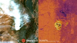
Idaho to Deploy Satellite-Based Wildfire Detection With OroraTech
The Idaho Department of Lands will deploy a statewide satellite-based wildfire detection and monitoring system through a new partnership with OroraTech USA. OroraTech said Sept. 10 that the system uses […]
-
 Manufacturing
HawkEye 360 Orders Three New Satellite Clusters from SFL Missions
HawkEye 360 has ordered nine new spacecraft from SFL Missions, including spacecraft featuring upgraded antenna and radio systems. The satellites will be deployed in three clusters for HawkEye’s radio frequency […]
-
 Imagery and Sensing
Satellogic’s Deal With Suhora Expands Market to India and Nepal
Satellogic has a new strategic partnership with satellite data analytics company Suhora that gives Suhora exclusive rights to market Satellogic’s imagery and data in India and Nepal. Satellogic announced the […]
-
 Imagery and Sensing
Nuview Gets $5M DoD Award to Develop LiDAR Payload
Nuview has been awarded additional $5 million in funding from the Department of Defense’s National Security Innovation Capital (NSIC) program for development of its LiDAR payload. Nuview said this funding […]
-
 Finance
Sumitomo Corporation Invests in Ursa Space
Sumitomo Corporation of Americas has invested into Ursa Space Systems to help the company serve customers across Asia, particularly in the Japanese market. The firm is the largest subsidiary of […]
-
 Imagery and Sensing
BlackSky Lands Expansion Deal With HEO for Space Domain Awareness Imaging
BlackSky Technology has signed a seven-figure expansion contract with HEO to provide imagery of objects in space for space domain awareness monitoring. HEO is an Australian startup specializing in non-Earth […]
-
 Government/Military
India’s IN-SPACe Selects Pixxel to Lead National EO Constellation Project
India is investing in a national Earth Observation (EO) constellation, selecting Pixxel to lead a consortium of companies under a public-private partnership framework. The Indian National Space Promotion and Authorization […]
-
 Imagery and Sensing
EO Geospatial Data Services Market Revenues Set to Rise Significantly
The Global Earth Observation (EO) geospatial data services market is set to be worth around $15 billion in revenue by 2030. This is according to new research by technology intelligence […]
-
 Finance
BlackSky Optimistic for US Gov Opportunities Despite Budget Volatility
While BlackSky has lowered its full-year outlook for 2025, citing the “near term volatility” of the U.S. government budget process, CEO Brian O’Toole told investors on Thursday that BlackSky believes […]
-
 Imagery and Sensing
SatSure Looks to Bring Satellite Benefits to Kenya’s Agricultural Sector
Satellite data is set to play a pivotal role in boosting agricultural productivity in Kenya. SatSure Analytics, an Earth Observation (EO) data refinery platform operator, has partnered with Kenya Agricultural […]
-
 Imagery and Sensing
SFL Missions to Develop Maritime Monitoring Satellite for Norway
SFL Missions Inc. will develop a microsatellite for the Norwegian Space Agency for maritime ship tracking under a contract announced July 29. The AISSat-4 satellite, targeted for lunch in less […]
-
 Imagery and Sensing
Eycore and NanoAvionics to Deploy SAR Satellite for Europe
Polish payload developer Eycore will fly its first synthetic aperture radar (SAR) demonstrator on a Kongsberg NanoAvionics satellite bus under a deal announced Thursday. The flight will test Eycore’s X-band […]
-
 Imagery and Sensing
Planet Signs Contract Extension with Colombia’s IGAC for Land Management
Planet has signed a multi-year contract expansion with Colombia’s government entity responsible for geographic data to continue to use Planet’s technology for land management, adding AI capabilities to track change […]
-
 Imagery and Sensing
Spire Targets Aviation Market with New Service Launch
Spire Global is targeting the aviation market with a new analytics service launch. Spire is rolling out Aircraft Exposure Analytics, an aviation solution that enables users to quantify aircraft-level exposure […]
-
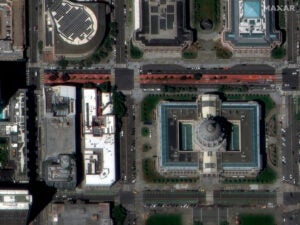
 Imagery and Sensing
Maxar Nabs $205M in International Contracts for Defense and Intel Capabilities
Maxar Intelligence on Tuesday said it received $204.7 million in new multi-year contracts from three existing customers in the Middle East and Africa (MEA) region to boost sovereign defense and intelligence […]
-
 Imagery and Sensing
MethaneSAT Loses Contact With Satellite
Methane-monitoring satellite MethaneSAT has lost power and communications, the team behind the mission said in an update on Tuesday. The MethaneSAT mission operations team lost contact with MethaneSAT on June […]
-
 Government/Military
Planet Highlights Defense Momentum With $280M German Government Deal
Planet announced a new 240 million euro ($283 million) multi-year deal with the German government on Tuesday for satellite imagery and analytics services, which Planet’s leadership pointed to as a […]
-
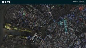 Government/Military
Finnish MoD Looks to Purchase SAR Satellites from Iceye
The Finnish Ministry of Defense is looking to purchase satellites from Iceye for intelligence and surveillance capabilities from space, under a new letter of intent announced June 27. The letter […]
-
 Government/Military
Maxar Intelligence Receives Luno A Order from NGA
The National Geospatial-Intelligence Agency (NGA) has awarded Maxar Intelligence a delivery order under the Luno A program for commercial analytic services. Maxar said on June 27 the order specifically deals […]