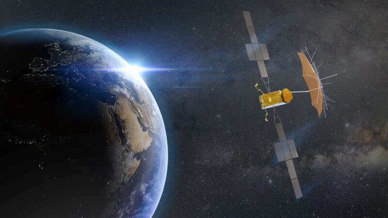
Earth Observation Data Analytics (EOSDA) is looking to use satellite technology to make a difference in the areas of agriculture, oil and gas, forestry, and disaster recovery. The company recently announced plans to launch seven optical EOS SAT satellites into Low-Earth Orbit (LEO) by 2024.
One of the key objectives of this new satellite constellation will be monitoring farmlands. Dr. Max Polyakov, managing partner of Noosphere Ventures, is the founder of EOSDA is one of the industry’s burgeoning talents. In a recent conversation with Via Satellite, Polyakov shared why he is confident that EOSDA will become one of the winners in the LEO sector.
VIA SATELLITE: How many satellites are you targeting, and how will you fund the constellation over the next few years?
Polyakov: It will depend on the final size of the constellation. Our current plans for seven satellites will allow us to provide a revisit time of one to three days for the core agricultural regions. If there is a need to shorten the revisit time – to one day, or to provide whole Earth coverage permanently – then the constellation will be expanded.
We’re also negotiating a potential partnership with several large strategic market players who are interested in co-investing in the constellation. These negotiations will affect the final result. These strategic investors have knowledge of our target markets and understand the importance of providing timely, accurate data about Earth for business and scientific pursuits.
We are now optimizing the production technology for our constellation in order to provide the most cost-effective option. For example, thanks to the use of dual cameras, we have increased the swath range from 20 km to 40 km. This gives us the opportunity to reduce the total cost of the constellation by using fewer satellites to cover our target territories.
VIA SATELLITE: What do you see as the challenges for EOSDA to be successful in this market?
Polyakov: The biggest challenge is to establish ourselves as a valuable player in the competitive agriculture satellite monitoring market. This will take time – we’ll demonstrate our advantages, build our reputation as a dependable source of high-quality proprietary imagery with features our competitors can’t match, and let the market take its natural course. We will succeed precisely because we are building a vertically-integrated ecosystem where we clearly understand what solutions our satellites will provide in order to resolve our end-user’s actual problems.
We’re offering our customers a chance to reap the benefits of merging a proprietary analytics platform with satellite data. Since we’re relying on in-house production, we can also offer our agricultural customers a unique set of ready-made agricultural solutions at an affordable price. Secondly, we are working to ensure that our efforts are scalable and can be used in any region or territory, though we will need time to deploy our technologies around the world.
VIA SATELLITE: Who are your key target customers? What is the difference between targeting individual farmers and big farming organizations?
Polyakov: The major difference here is the scale, as large agricultural concerns use satellite data for remote field monitoring, while small farmers rely on satellite monitoring mostly for resource optimization. With that in mind, we have three main targets, in no particular order: First, local integrators who have a solid presence in their market. These are the firms that will distribute and introduce precision farming technologies into local agricultural workflows. We’re also looking at input suppliers, since they’re interested in creating comprehensive approaches for covering a farmer’s needs. Last but not least, are the farmers themselves. We know that our solutions are effective because we’re already a globally-recognized resource, with 4 million hectares of fields under coverage across 56 countries.
Specifically, we are talking about the following tasks: field boundaries, NDVI indexes, vegetation & field health statuses, biophysical characteristics of vegetation, zoning, variable rate seeding/prescription & zone manager, crop classification, scouting, harvest monitoring, fertilization management, field forecasting, irrigation, and soil moisture analysis.
VIA SATELLITE: What do you see as EOSDA’s competitive advantage over other LEO constellations also targeting the agriculture sector?
Polyakov: We’re focusing on band quantities and parameters optimized specifically for solving agricultural modelling problems. As an example, we’ll use satellite bands that will allow us to obtain biophysical parameters, such as Leaf Area Index (LAI). Currently, only gold standard satellites (Sentinel/Landsat/Modis) can provide a sufficient number of bands. But they have a critical drawback – an insufficient revisit rate of eight days or more.
There are no similar solutions on the market. Typically, only four channels are put on the camera of the optical satellite, but these are not enough for agro modelling tasks. We chose a different path, by designing a camera that would allow us to obtain the required images. Our first satellite will contain a matrix of 11 bands (spectral bands aligned with Sentinel-2 for sensor harmonization). They’re being designed to allow us to calculate three SWIR virtual channels using mathematical modeling and special algorithms.
These technical details aren’t the only reason that I’m confident in our success. We’ve also got enormous expertise in transforming this data into a ready-made solution for our clients. This knowledge is born out of many years of working with satellite images, getting a sense of what channels are important and what’s needed and lacking in existing solutions, and an understanding of how to properly package all of this for our end user.
Ultimately, we’re going to be a boon for any sized agricultural concern, from smallholders, to large agricultural enterprises, and even insurance companies and governments. Our key competitive advantage is our ability to provide anyone in the industry a solution to a vast number of agricultural challenges thanks to the vertically integrated ecosystem we develop.
VIA SATELLITE: What are your plans during the next year in terms of investing in ground segment and other satellite technologies?
Polyakov: It is going to be an extremely exciting year for us. Along with the EOS SAT constellation, we are launching radar satellites, EOS SAR [Synthetic Aperture Radar], that we announced the year before. One of our goals is to synergize these two constellations, delivering both optical and radar data.
The EOS SAR project is developing an X-band synthetic aperture radar while keeping the total payload weight below 50 kg, thanks to a light-weight deployable mesh reflector antenna. A prototype has successfully passed ground tests, and the team is now focused on building and testing a fully functional engineering model of the SAR satellite.
Additionally, Dragonfly Aerospace is aiming to complete development of the optical payload. They’re planning to move into the final stage for satellite manufacturing and integration, which should mean that we’ll have a satellite and payload in the clean room by the end of the year.
The year following, 2023, satellite data from our burgeoning constellation will be integrated with our analytics solutions, and we’ll be exploring partnership opportunities for scaling. And in 2024, we expect that we’ll have all seven of our satellites for the constellation in orbit and watching over Earth.
VIA SATELLITE: How do you see the market evolving for satellite imagery and analytics?
Polyakov: We’re doing very well across verticals with our portfolio projects across 22 industries, from agricultural analytics and climate change monitoring, disaster management, oil and gas, forestry to green energy and real estate. There’s no real upper bound on the usage of satellite analytics. Both data quality and analytics are expected to improve significantly in coming years thanks to advancing technology – this means ever-more accurate predictive models.
That’s why EOS SAT will be able to send images in eleven different band channels, so we’re looking at improved applications not just for predictive models, but also for optimized irrigation management, optimal nitrogen usage in fields, and in general, a better decision support system for agriculture.
VIA SATELLITE: What are your long-term ambitions for EOSDA?
Polyakov: I’ve set our sights quite high. It’s important to understand that this isn’t just a business project to me, or to anyone at EOSDA. We all strongly believe and are working to realize our mission of using space for the benefit of humanity.
That’s why we’re striving towards these goals to expand the reach and use of satellite data, and to constantly improve the models and algorithms that data informs. Long-term, our EOS SAT constellation will play a huge role in realizing that mission for the agriculture industry. Paired with the 12 radar satellite group we’re developing under the auspices of the EOS SAR project, it will generate synergies that will be capable of providing a complete overview for nearly any industry or scientific challenge humankind can be expected to face in the coming decades.