
Imagery and Sensing
-
 Connectivity
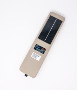
AssetLink Global Leverages Cellular Tech for Global Connectivity
AssetLink Global has launched its next generation AssetPack Internet of Things (IOT) device family designed for multi-mode simple to advanced tracking and managing of unpowered and powered assets located in […]
-
 Imagery and Sensing
Lindsay Corp. Partners With Farmers Edge to Digitalize Farms
Lindsay Corporation, a manufacturer and distributor of irrigation and infrastructure equipment and technology, and Farmers Edge, a provider of precision digital solutions for agriculture, have formed a new strategic partnership […]
-
 Imagery and Sensing
Antrix, SatSure to Further Geospatial Big Data Analytics
SatSure Analytics, a satellite data analytics company, has signed a strategic Memorandum of Understanding (MOU) with Antrix Corporation, the commercial arm of the Indian Space Research Organization (ISRO), to further […]
-
 Government/Military
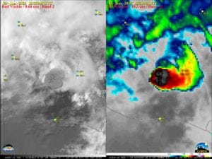
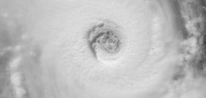
Guatemala’s Deadly Volcano as Seen via Satellite
On Sunday, a volcano erupted in Guatemala killing at least 25 people and injuring hundreds, according to Reuters. The eruption of Volcan de Fuego, which translates to Volcano of Fire, […]
-
 Government/Military
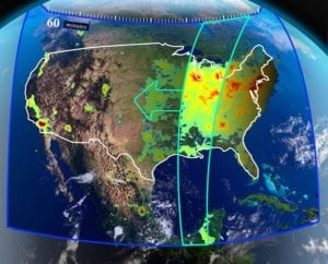
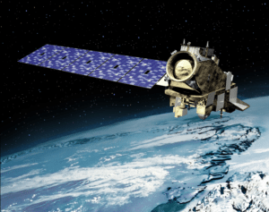
NOAA’s Most Advanced Weather Satellite Captures Stunning Images
The first imagery from the National Oceanic and Atmospheric Administration’s (NOAA) GOES-17 Advanced Baseline Imager (ABI) has made its public debut. The imagery of the Western Hemisphere was created using two […]
-
 Government/Military
NASA is Looking for a Commercial Satellite to Host TEMPO
A NASA instrument that will measure ozone and other key pollutants over North America is seeking proposals for hosting services. The Tropospheric Emissions: Monitoring of Pollution (TEMPO) instrument, flying on a commercial […]
-
 Government/Military
NASA Ups JPSS Contract with Raytheon by $59 Million
NASA has definitized additional requirements under the Joint Polar Satellite System (JPSS) Common Ground System contract with Raytheon of Aurora, Colorado. This cost-plus award fee modification will increase the contract by […]
-
 Government/Military
The First JPSS Satellite is Now Operational
The first satellite in the National Oceanic and Atmospheric Administration’s (NOAA) new Joint Polar Satellite System (JPSS) has passed testing and is now operational. Launched last November as JPSS-1 and renamed NOAA-20 once it […]
-
 Government/Military
Orbital ATK Wins Contract for Two More JPSS Spacecraft
NASA has exercised options under the Rapid Spacecraft Acquisition III (Rapid III) contract for two additional Joint Polar Satellite System (JPSS) spacecraft to be built for the National Oceanic and […]
-
 Finance
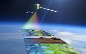
Esri Users to Receive Sentinel-2 Image Services For Free
Esri, a provider of spatial analytics, has announced that it is releasing Sentinel-2 image services to all Esri users for no additional cost. Sentinel-2 is an Earth observation satellite that […]
-
 Imagery and Sensing
DigitalGlobe Releases Commercial Version of Geospatial Big Data (GBDX) Notebooks
DigitalGlobe, a Maxar Technologies company, has announced the commercial release of Geospatial Big Data (GBDX) Notebooks, allowing customers to easily extract valuable insight they want from DigitalGlobe’s GBDX platform. GBDX […]
-
 Imagery and Sensing
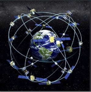
China’s BeiDou-3 Satellite Network Up and Running, State Officials Confirm
The first eight of 35 planned BeiDou-3 satellites have formed a functioning network, as first reported by Maritime Executive, and have a global positioning accuracy of five meters, according to […]
-
 Finance
Draper, VCs Invest $34 Million in Finnish Microsatellite Startup
Iceye, an Earth observation company providing synthetic-aperture radar (SAR) data, has announced $34 million Series B funding led by return investor True Ventures and supported by Draper Network VC funds […]
-
 Imagery and Sensing
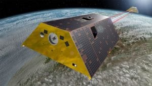
GRACE-FO Mission Set To Record Climate Data After SpaceX Launch
The twin Gravity Recovery and Climate Experiment Follow-On (GRACE-FO) satellites, developed and built by Airbus, are closer to continuing the climate record established by the predecessor GRACE mission of 2002–2017, […]
-
 Imagery and Sensing
Teledyne e2v Wins Second Phase of $47 Million PLATO Mission Contract
The European Space Agency (ESA) has awarded Teledyne e2v, a division of Teledyne Technologies Incorporated, with the second phase of a €42 million ($47 million USD) contract to produce high-end […]
-
 Government/Military
Sener to Develop Optical Bench for ESA’s Flex Satellite
Sener has won a contract to develop the optical bench for the main instrument of the European Space Agency (ESA) satellite Flex, an acronym for Fluorescence Explorer. This is the eighth member […]
-
 Imagery and Sensing
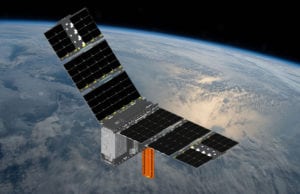
Orbital ATK Takes Ohio State First CubeSat to Space
Orbital ATK successfully launched the company’s Antares rocket carrying its Cygnus spacecraft from the Mid-Atlantic Regional Spaceport Pad 0A on Wallops Island, Virginia, at NASA’s Wallops Flight Facility. The launch […]
-
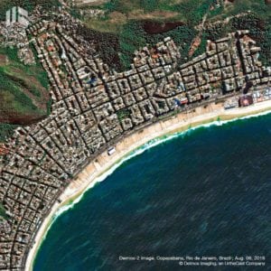 Government/Military
Deimos Imaging Wins Defense Contract in Brazil
UrtheCast has announced that its Earth observation subsidiary Deimos Imaging has entered into a contract with the Brazilian Ministry of Defense’s Aeronautics Command (COMAER) exceeding $2.6 million. The contract requires […]
-
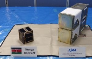 Imagery and Sensing
JAXA Deploys Kenya’s First Satellite Into Orbit from ISS
The first Kenya University Nano Satellite Precursor Flight (1KUNS-PF), Kenya’s first satellite, was successfully deployed from the Japan Space Agency (JAXA) KIBO deployment module aboard the International Space Station (ISS). 1KUNS-PF […]
-
 Government/Military
Sener to Develop Biomass Satellite Assembly Devices for ESA
Sener will design, manufacture and test devices for the assembly of the Biomass satellite, a mission of the European Space Agency (ESA) under the Earth Explorer program. The program’s objective is […]
-
 Government/Military
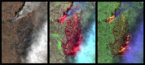
Satellite Images of Kilauea Volcano Effects Emerge
The eruption of Kilauea Volcano on the island of Hawaii triggered a number of gas- and lava-oozing fissures in the East Riff Zone of the volcano. Kilauea has been erupting continuously […]
-
 Imagery and Sensing
Space Situational Awareness in the Era of Megaconstellations
At the SATELLITE 2018 Conference & Exhibition, I joined a panel to discuss Space Situational Awareness (SSA), something that was particularly pertinent given a certain incident that week involving a […]
-
 Imagery and Sensing
MDA, Nanowave Team Up for Radar Transceiver Payload
MDA, a Maxar Technologies company, has signed a multi-million-dollar contract with Nanowave Technologies, a designer and manufacturer of advanced microwave, millimeter-wave and electro-optic multi-function modules and subsystems. MDA will provide satellite components […]
-
 Imagery and Sensing
Airbus Aerial, DroneBase to Provide Data Services
Airbus Aerial and DroneBase, a global drone operations company, have announced a partnership to deliver a multi-source data service solution for aerial imagery and data from a single provider. This […]
-
 Government/Military
SBIRS GEO Flight-4 Sends First Images Back to Earth
The U.S. Air Force’s fourth Space Based Infrared System (SBIRS) satellite transmitted its first images back to Earth. The milestone, known as “first light,” occurred in February when the SBIRS […]
-
 Imagery and Sensing
Using Satellite Data to Meet Sustainability Goals
Fred Krupp, president of Canada’s Environmental Defense Fund (EDF), gave a recent TED talk about the organization’s plans to launch a satellite in orbit that will gather data about the […]
-
 Finance
Is the Data Worth More Than the Link?
In the good old days — before today’s bandwidth bonanza began pushing transponder capacity prices ever lower — the point of most satellite communications was the communications. It was about […]
-
 Government/Military
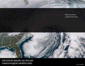
Harris to Help NOAA Monitor Interference of Satellite Data
The National Oceanic and Atmospheric Administration (NOAA) has selected Harris Corporation to design a system to monitor cellular signals interfering with critical weather satellite data. Several weather satellites soon will […]
-
 Government/Military
The Importance and Capability of Satellite Imagery
In honor of Jim Bridenstine’s confirmation to the post of NASA Administrator, I present three stories highlighting the importance and capability of satellite imagery to study and better know our […]
-
 Imagery and Sensing
China’s Long March Launches SmallSats to Orbit
China launched its fourth Long March-11 (LM-11) rocket on Thursday, carrying multiple small satellites into orbit. The launch took place from a mobile launch platform at the Jiuquan Satellite Launch […]