
Imagery and Sensing
-
 Government/Military
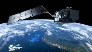
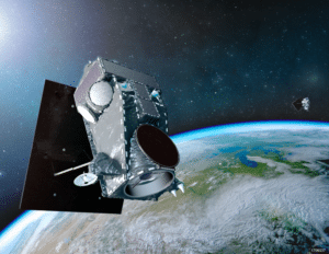
Lift-off: Sentinel-3B Join its Twin Sentinel-3A in Orbit
The seventh Sentinel satellite from the European Earth observation program Copernicus has been placed into space following the successful launch on April 25. The 1,150kg Sentinel-3B satellite was carried into […]
-
 Finance
Deimos Imaging Makes History with US GSA Contract
Deimos Imaging and UrtheCast have won a GSA Multiple Award Schedule (MAS) 070 contract by the United States General Services Administration (GSA), the procurement arm of the federal government. The five-year […]
-
 Finance
DigitalGlobe: More Imagery Available, New Rapid Access Program
DigitalGlobe, a Maxar Technologies company, has announced that with the complete integration of its WorldView-4 satellite imagery into SecureWatch, the company’s cloud-based Geospatial Intelligence (GEOINT) platform, customers can now access […]
-
 Imagery and Sensing
EarthNow Aims to Deliver Real-Time Video of Earth via Satellite
EarthNow has announced it intends to deploy a large constellation of advanced imaging satellites that will deliver real-time, continuous video of almost anywhere on Earth. The latest company to spin-out […]
-
 Finance
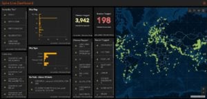
Spire Data Now Accessible on Esri ArcGIS platform
Spire Global, a space to cloud analytics company that uses proprietary satellite data and algorithms to provide advanced maritime, aviation, and weather tracking, has announced its participation in the Esri […]
-
 Finance
AI and Satellite Imagery to Power a New Revolution in Agribusiness
Agronow is spearheading a new revolution it calls Agriculture 5.0, through which it aims to monitor crops by using Artificial Intelligence (AI), making it possible for all sectors involved in […]
-
 Connectivity
KSAT to Provide Ground Station Services for Hawkeye
HawkEye 360 has selected Norway’s Kongsberg Satellite Service (KSAT) to provide ground station services for its pathfinder mission. HawkEye 360 plans to use its commercial satellite constellations to identify and […]
-
 Imagery and Sensing
How Satellites Could Improve Oil Spill Cleanups in the Ocean
According to speakers at Interspill 2018 in London, satellites could be a major help for those tasked with cleaning up disastrous oil speaks at sea. Synthetic Aperture Radar (SAR) could […]
-
 Imagery and Sensing
EDF’s New Satellite Will Measure Human-Sourced Methane
The Environmental Defense Fund (EDF) announced plans to develop and launch a new satellite purpose-built to identify and measure methane emissions from human-made sources worldwide, starting with the oil and […]
-
 Imagery and Sensing
Satellites Still Fall Short in Agricultural Tracking
Although both government and private entities have used satellite imagery for agricultural purposes for years, the U.S. Department of Agriculture (USDA) says the technology still hasn’t peaked in maturity. The […]
-
 Imagery and Sensing
DigitalGlobe to Map Buildings Using Machine Learning in the Cloud
DigitalGlobe has formed a partnership with Ecopia Tech to use proprietary Artificial Intelligence (AI) algorithms and cloud computing to create building footprints. By using Ecopia’s U.S. Building Footprints powered by […]
-
 Government/Military
SSL to Equip JPL’s Europa Clipper Spacecraft
NASA’s Jet Propulsion Laboratory (JPL) has selected SSL to design and build critical equipment for a spacecraft that will explore Europa, one of Jupiter’s moons. The Europa Clipper spacecraft, set to […]
-
 Government/Military
NOAA Activates Northrop Grumman Instruments on New Satellite
The National Oceanic and Atmospheric Administration (NOAA) successfully activated two instruments built by Northrop Grumman on its newest weather satellite, which is performing post-launch procedures nominally after reaching orbit. The […]
-
 Finance
World View Successfully Closes Fundraising Round at $26.5 Million
World View announced that it has successfully closed a $26.5 million Series C financing round led by Accel. The Series C also included major investment by Canaan and Norwest Venture […]
-
 Government/Military
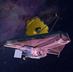
James Webb Space Telescope to Launch in 2020 Now
NASA announced another delay for its $8.8 billion James Webb Space Telescope (JWST) project pushing back the potential launch date to May 2020 following continued integration and testing issues. Problems […]
-
 Government/Military
MDA Signs Multiple Contracts for Radarsat 2 SAR Data
MDA has recently signed multiple geospatial-related contracts based on data from the Radarsat 2 Synthetic Aperture Radar (SAR) satellite. According to MDA, the contracts have a combined value of approximately […]
-
 Government/Military
ESA Partners with Iceye to Explore Earth Observation Opportunities
Iceye has announced a partnership with the European Space Agency (ESA) to mutually explore opportunities provided by Iceye’s technology. The cooperation encompasses activities that focus on the design of Iceye’s […]
-
 Government/Military
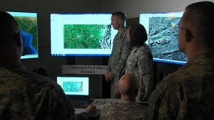
Army Geospatial Center Extends Contract with Radiant Solutions
Radiant Solutions has signed a follow-on contract with the Army Geospatial Center (AGC) valued at $2.6 million for its Remote Ground Terminal (RGT) program. AGC exercised an option extending Radiant […]
-
 Government/Military
Regional Data Cube to Help Manage Food Security in Africa
The African Regional Data Cube has been launched at the Global Partnership for Sustainable Development Data’s inaugural Data for Development Festival in the United Kingdom. This new tool harnesses the […]
-
 Government/Military
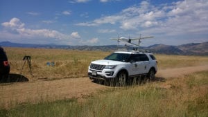
Black Swift and NASA to Advance Agricultural Drone Tech
Black Swift Technologies announced the expansion of a pathfinder mission with NASA’s Goddard Space Flight Center to develop enhanced multi-angular remote sensing techniques using small Unmanned Aircraft Systems (UAS). According […]
-
 Imagery and Sensing
Fleet Space to Trial Precision Farming Tech in Tasmania
Fleet Space Technologies has joined forces with researchers at the University of Tasmania (UTAS) in the world of Big Data, sensors and space technology to trial their first local precision […]
-
 Government/Military
NASA Green Lights Landsat 9 Build from Orbital ATK
NASA has given Orbital ATK approval to begin building its Landsat 9 spacecraft after completing a comprehensive design review of the mission. Landsat 9, a land surface mapping satellite, will […]
-
 Finance
SpaceX Will Launch DigitalGlobe’s Next Satellites in 2021
DigitalGlobe and SpaceX are working together for the first time to launch the WorldView Legion constellation. Two flight-proven Falcon 9 rockets will launch the initial block of the multi-satellite WorldView […]
-
 Imagery and Sensing
With its First EO Satellite Completed, BlackSky Now Waits for Launch
BlackSky, the geospatial intelligence service of Spaceflight Industries, announced the first of its next generation of small Earth Observation (EO) satellites is complete, qualified, and awaiting launch. This spacecraft, called […]
-
 Government/Military
ULA Orbits Advanced Weather Satellite for NOAA
NASA and United Launch Alliance (ULA) successfully launched the second in a series of next-generation weather satellites this week for the National Oceanic and Atmospheric Administration (NOAA). At 5:02 p.m. […]
-
 Government/Military
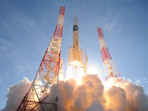
Japan to Monitor North Korea with New Satellite
On Feb. 28, Japan successfully launched a new optical reconnaissance satellite from Tanegashima Space Center in Kagoshima Prefecture. The spacecraft (the details of which are highly classified) will join a […]
-
 Government/Military
Radiant Solutions to Accelerate Machine Learning Tech for NGA
Radiant Solutions announced a contract with the U.S. National Geospatial-Intelligence Agency (NGA) to provide more than 1 million labeled objects within high-resolution satellite images that will be used to accelerate […]
-
 Government/Military
MDA to Design Optical Comms Payload for Airbus
MDA announced that it has signed a contract valued at approximately CA$4 million ($3.1 million) with Airbus for design studies dedicated to the optical data relay payload of the third […]
-
 Government/Military
The Pentagon Is Asking for Satellite Imagery Algorithms
A unit in the Pentagon has put out a call for algorithms that can be used to analyze high-resolution satellite imagery. The contest, called the xView Detection Challenge, will award […]
-
 Connectivity
SpaceX Orbits Spain’s Paz and Its First Starlink Test Satellites
First two Starlink demo satellites, called Tintin A & B, deployed and communicating to Earth stations pic.twitter.com/TfI53wHEtz — Elon Musk (@elonmusk) February 22, 2018 SpaceX completed its third successful launch […]