
Imagery and Sensing
-
 Imagery and Sensing
NATO Taps Planet Labs to Track Global Threats with SkySat Imagery
Planet Labs will provide high-resolution satellite data to support the NATO Communications and Information Agency‘s (NCIA) Alliance Persistent Surveillance from Space (APSS) program under a new contract the company announced […]
-
 Imagery and Sensing
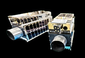
Maxar Confirms Successful Launch for Second Batch of WorldView Legion Satellites
The second batch of Maxar Intelligence WorldView Legion satellites are now in the commissioning phase after a SpaceX launch on Thursday morning. SpaceX launched the two satellites on a Falcon […]
-
 Manufacturing
GHGSat Orders 2 More Greenhouse Gas Monitoring Satellites from Space Flight Laboratory
GHGSat has contracted Space Flight Laboratory to build two additional greenhouse gas monitoring satellites for the company’s constellation. The satellites, announced Monday, will be based on the SFL 15-kg NEMO […]
-
 Imagery and Sensing
Umbra Begins Selling SAR Satellites to Customers
Satellite data provider Umbra is expanding its business from selling imagery collected by its synthetic aperture radar (SAR) satellites, to selling the satellites to customers. Umbra announced its new Mission […]
-
 Imagery and Sensing
GHGSat Methane Data to Be Available in NASA’s Commercial Smallsat Data Program
Methane-tracking satellite operator GHGSat has completed an evaluation process to join NASA’s Commercial Smallsat Data Acquisition program (CSDA). This will make GHGSat’s methane emissions data available for scientific research and […]
-
 Government/Military
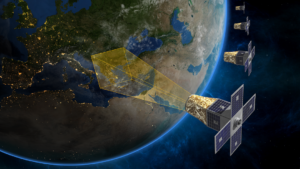
Planet Expands Imagery Deal with Allied Government
Planet Labs signed a seven-figure contract expansion with a U.S.-allied international government agency for SkySat satellite data. Planet announced the SkySat expansion with the unnamed allied nation on Monday. Specific […]
-
 Imagery and Sensing
e-GEOS Wins European Environmental Contract
e-GEOS has won a new five-year contract from the European Environment Agency (EEA) which will enable better detection and measurement of ground movements from space. The contract is for the […]
-
 Imagery and Sensing
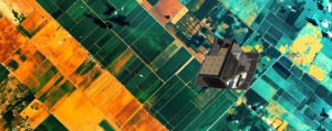
Maxar Releases the First WorldView Legion Images
Maxar Intelligence released the first set of images from its new WorldView Legion satellites. The images released Thursday show the 30 cm-class imagery capabilities of the satellites, capturing views of […]
-
 Imagery and Sensing
Planet Signs Seven-Figure Pilot Program With International MoD Customer
Planet Labs has signed a new seven-figure pilot program with an international ministry of defense (MoD) customer for PlanetScope data enhanced with SynMax artificial intelligence. Planet announced the deal with […]
-
 Government/Military
Government is Behind in Creating a Program of Record for Commercial Satellite Imagery, Iceye US Exec Says
Commercial satellite radar providers are ready to meet the operational needs of U.S. government users but plans to develop a program of record for these capabilities in fiscal year 2026 […]
-
 Imagery and Sensing
AAC Clyde Space Partners With Scotland on Earth Observation Constellation
AAC Clyde Space signed an agreement with the Scottish government to offer Earth observation data through the planned Cyclops satellite constellation. This is AAC Clyde Space’s first customer for the […]
-
 Sustainability
OroraTech to Use Satellite Tech to Help Greek Wildfire Response
OroraTech, the German satellite data company, will now play a key role in helping emergency services and the government in Greece as they fight wildfires, a major problem in Greece. […]
-
 Imagery and Sensing
NASA Leader Emphasizes Satellite Data and Collaboration to Combat Climate Change
NASA wants to play a key role alongside the commercial satellite industry to use satellite technology to help avert the climate crisis. In a recent keynote at the Earth Observation […]
-
 Finance
Synspective Raises $44M in Series C Round
Synspective has secured another 7 billion yen ($44.1 million) in a Series C funding round. The Japanese synthetic aperture radar (SAR) satellite data and analytics solutions provider, will use the […]
-
 Imagery and Sensing
Japan’s NEC and Ursa Team Up in Satellite Data Arena
NEC is teaming up with Ursa Space Systems on satellite image data analysis services. The Japanese tech giant has made an interesting new foray into satellite with this collaboration. The […]
-
 Imagery and Sensing
Spire and Thales to Build Air Traffic Management Constellation
Spire Global is working with Thales and European Satellite Services Provider (ESSP) to build a specialized satellite constellation for air traffic management. The companies announced a memorandum of cooperation on […]
-
 Imagery and Sensing
SES, Planet Complete Successful Data Relay Demonstration for NASA
SES Space & Defense has demonstrated what it claims is the first multi-orbit, multi-band commercial space relay service in support of the NASA Communications Services Project (CSP). To demonstrate data […]
-
 Imagery and Sensing
Denmark’s Space Inventor Forms Maritime EO Surveillance Partnership with Addvalue
Danish satellite company Space Inventor is teaming up with Addvalue for a mission that aims to show tactically smarter Earth Observation (EO) in the area of maritime surveillance. A new […]
-
 Imagery and Sensing
Scout Space’s Sparrow Payload Captures first Calibration Image
In-space security observation service provider Scout Space commissioned and captured the first in-space calibration image from its recently launched “Sparrow” optical payload, the company announced Thursday. SpaceX launched Scout’s Sparrow […]
-
 Imagery and Sensing
BAE Systems to Build All Three Hyperspectral Instruments for NOAA’s GeoXO Constellation
The National Oceanic and Atmospheric Administration (NOAA) awarded a contract to BAE Systems to build the Ocean Color Instrument (OCX) for its Geostationary Extended Observations (GeoXO) satellite constellation. The new […]
-
 Imagery and Sensing
BlackSky Secures $7M Government Contract Renewal for Spectra Analytics Platform
Space-based imagery and analytics company BlackSky Technology inked a $7 million contract renewal with one of its existing international government customers on Friday to continue providing satellite monitoring services. BlackSky […]
-
 Imagery and Sensing
Open Cosmos Wins ESA Deal to Build EO Constellation for Greece
The European Space Agency (ESA) awarded Open Cosmos a 60 million euro ($65 million) contract to build a multisensor Earth observation (EO) constellation for Greece. It is a flagship project […]
-
 Imagery and Sensing
Planet Extends its Digital Farming Contract with Germany’s BASF
German smart agriculture company BASF Digital Farming GmbH will expand the scope of its existing contract with Planet Labs in order to access more data from Planet’s Crop Biomass Planetary […]
-
 Imagery and Sensing
SatVu Orders 2 Thermal Imaging Satellites from SSTL
SatVu has ordered two additional thermal imaging satellites from Surrey Satellite Technology (SSTL), HotSat-2 and HotSat-3. The satellites are both scheduled to launch in 2025. SatVu also announced on May […]
-
 Imagery and Sensing
Open Cosmos CEO Pitches Partnership with IoT Startup Connected
Open Cosmos is a company to watch in the European Earth observation (EO) market as it looks to bring the benefits of small satellites to enterprises all over the world. […]
-
 Imagery and Sensing
Marble Imaging and Reflex Aerospace to Deploy EO Satellite Network
Marble Imaging is teaming up with Reflex Aerospace to build a new Earth observation (EO) constellation. Marble Imaging, based in Bremen, Germany, is planning a constellation of up to 200 […]
-
Finance
BlackSky Reports $24.2M Revenue in Q1 2024
BlackSky reported $24.2 million in revenue in the first quarter of 2024, up 32% from the same time last year. The company released its Q1 financials on May 8. Imagery […]
-
 Government/Military
Intelligence, Operating Entities Need to Shed ‘NOFORN’ Mindset, Space Operations Chief Says
KISSIMMEE, Fla. — U.S. history shows the country does not go to war alone and, amid war in Central Europe and coercive activities by China against its neighbors, America will […]
-
 Sustainability
Muon Space and Earth Fire Alliance Plan FireSat Constellation to Target Wildfires
Muon Space and Earth Fire Alliance are working together to build a new satellite constellation to aid in global wildfire response, called the FireSat Constellation. The initiative has the expertise […]
-
 Government/Military
DARPA Selects Northrop Grumman, Umbra for Phase II of DRIFT Program
Northrop Grumman and Umbra have been awarded small contracts by the Defense Advanced Research Projects Agency (DARPA) to continue to the second phase of a program designed to collect data from radar-equipped […]