
Imagery and Sensing
-
 Imagery and Sensing
Iceye to Supply Flood and Bushfire Data to Australian Government
The Australian government signed a deal with Iceye for flood and bushfire hazard data across the country. The agreement for access to Iceye’s synthetic aperture radar (SAR) satellite imagery will […]
-
 Imagery and Sensing
Wyvern Signs With Loft Orbital to Expand its Hyperspectral Constellation
Hyperspectral startup Wyvern is working with Loft Orbital to expand its Dragonette satellite constellation, booking a slot on an upcoming Loft Orbital mission. Wyvern will be a part of a […]
-
 Government/Military
NRO, NGA, Space Command Release Portion of Framework to Protect Commercial Remote Sensing Satellites
The intelligence community and U.S. Space Command (USSPACECOM) on Thursday released the executive summary of a new framework that outlines the roles and responsibilities of the government in helping to protect […]
-
 Finance
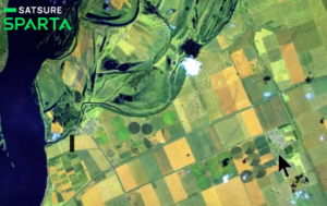
India-based EO Startup SatSure Raises $15M Series A Round
SatSure, an Earth observation startup based in India and focused on using satellite data for agricultural insurance use cases, raised $15 million in a Series A round. Baring Private Equity […]
-
 Imagery and Sensing
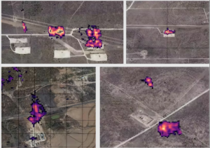
Orbital Sidekick Shares First Images from Hyperspectral Satellites
Orbital Sidekick (OSK) shared the first images from its three hyperspectral satellites launched on two SpaceX rideshare missions earlier this year. The satellites are the first in the GHOSt constellation, […]
-
 Imagery and Sensing
Hong Kong University Prepares to Launch Earth Observation Satellite
The Hong Kong University of Science and Technology (HKUST) plans to launch a multi-spectral optical satellite on Friday, Aug. 25, a first for major university in Hong Kong. HKUST announced […]
-
 Imagery and Sensing
Quant Data & Analytics to Leverage Satellogic Imagery in Saudi Arabia
Satellogic signed an agreement with Quant Data & Analytics, a Saudi provider of data solutions for real estate and retail sectors. Quant plans to use Satellogic’s high-resolution satellite imagery to […]
-
 Imagery and Sensing
Rocket Lab Snags Launch Deal with Japan’s iQPS
Japanese Earth imaging company iQPS has tapped Rocket Lab for a dedicated Electron launch, switching mission providers after Virgin Orbit went out of business. The mission is set for September […]
-
 Government/Military
NOAA Awards MyRadar a Grant for 2 Pathfinder Satellites
The National Oceanic and Atmospheric Administration (NOAA) awarded weather app MyRadar a grant for a satellite mission to improve resilience against wildfires. MyRadar announced the Phase II small business innovation […]
-
 Finance
Planet Closes Sinergise Acquisition
Planet has closed its acquisition of Slovenian company Sinergise to expand and enhance its Earth Data Platform. Planet announced the acquisition in March of this year. Sinergise makes the technology […]
-
 Finance
Spire Posts Record Revenue, Loss Reduction in 2Q 2023 Just Before Planned Stock Split
Space-based data, analytics and space services provider Spire Global turned in one of its best fiscal quarter performances in 2Q 2023, reporting its strongest revenue haul and lowest operating loss […]
-
 Finance
BlackSky Posts Double-Digit Revenue Increase in Q2
BlackSky Technology reported $19.3 million in revenue in the second quarter of 2023, up 28% from the prior year period, citing increased demand for satellite imagery and monitoring. The company […]
-
 Government/Military
NOAA Eliminates Certain Restrictions on Commercial Remote Sensing Companies
The U.S. government lifted certain restrictions on commercial remote sensing satellite companies on Monday. The changes came from NOAA’s Commercial Remote Sensing Regulatory Affairs (CRSRA) office, which is a division […]
-
 Imagery and Sensing
IBM and NASA Release Open Source Geospatial AI Foundation Model
IBM announced this week that IBM’s geospatial foundation model watsonx.ai, which is built from NASA‘s satellite data, will now be openly available on AI platform Hugging Face. IBM says this […]
-
Government/Military
UK Space Agency Increases Funding for Satellite EO Technologies
The UK Space Agency (UKSA) is committing a further 15 million pounds ($19.1 million) in funding for satellite Earth observation (EO) technologies. The UKSA announced the new initiative Aug. 2. […]
-
 Finance
Kleos Space to File for Bankruptcy
Radio frequency (RF) data provider Kleos Space is preparing to file for bankruptcy, announcing July 26 that it is unable to meet its financial obligations. The company said in a […]
-
 Government/Military
Pixxel Wins Grant to Build Multi-Payload Satellites for India’s Air Force
Indian hyperspectral earth-imaging technology firm Pixxel won a grant under the Indian Air Force‘s iDEX Prime program to manufacture miniaturized multi-payload satellites, the company announced Tuesday. Pixxel will to develop […]
-
 Imagery and Sensing
Spire Rolls Out New Weather Monitoring Platform Designed for Energy, Supply Chain Logistics
Space data and analytics provider Spire Global launched a new weather monitoring and alerting platform on Wednesday that it hopes will “revolutionize global weather awareness for the energy, supply chain […]
-
 Imagery and Sensing
ESA Taps Spire to Design Space-based Aircraft Surveillance System
The European Space Agency (ESA) awarded Spire Global a contract to design an aircraft surveillance system. It is a 16 million euro phased contract for a project called EURIALO, which […]
-
 Government/Military
PlanetiQ to Deliver GNSS-RO Data to NOAA Under Contract
PlanetiQ is beginning to deliver radio occlusion data to National Oceanic and Atmospheric Administration (NOAA) under a previously awarded contract. PlanetiQ announced this week it will begin daily delivery of […]
-
 Imagery and Sensing
RDC Aviation to Add Spire Aviation Data to its Platform
RDC Aviation, a tech and data services provider for the air transport industry, is a new customer for Spire Global’s aviation data. In a deal announced Tuesday, Spire will supply […]
-
 Finance
HawkEye 360 Says $58M Raise Will Advance RF Sensing and Processing Innovation
HawkEye 360 Inc. said on July 13 that it has raised $58 million in a Series D-1 round of funding from venture capital and private equity firms, including BlackRock, Manhattan Venture Partners, Insight […]
-
 Imagery and Sensing
OceanMind Extends Vessel-Tracking Data Deal With Spire
Marine enforcement company OceanMind is expanding its agreement with Spire Global for automatic identification system (AIS) vessel-tracking data. Spire has been providing AIS data to OceanMind since 2019. OceanMind supports […]
-
 Government/Military
DIU Contracts Muon Space to Evaluate Satellite Weather Data
Muon Space has been awarded an option to the company’s contract with Air Force Life Cycle Management Center (AFLMC) to collect ionospheric data on the MuSat-2 satellite mission. Under this […]
-
 Imagery and Sensing
Maxar Previews New Geospatial Platform
Maxar Technologies has a new Maxar Geospatial Platform (MGP) now available as an initial release, for access to Earth observation intelligence. The company said MGP was designed to simplify discovery, […]
-
Imagery and Sensing
HawkEye 360 Receives Australian Contract for Maritime Monitoring
The government of Australia has awarded HawkEye 360 a contract for a pilot program for maritime domain awareness in the Pacific Islands, the company announced July 6. The pilot program […]
-
 Sustainability
OroraTech and Spire Partner on Satellites to Track and Monitor Wildfires
OroraTech is expanding its partnership with Spire Global to build, launch, and operate an eight-satellite constellation dedicated to global temperature monitoring. The two companies announced the partnership on June 28. […]
-
 Government/Military
EU Adds 9 Startups to Contribute Data to Copernicus Mission
The European Union (EU) has added nine startups to contribute data to the Copernicus project. Each startup will receive a 5 million euro contract to provide additional data to Copernicus. […]
-
 Imagery and Sensing
HawkEye 360’s Cluster 7 Satellites Are Now Operational
HawkEye 360‘s Cluster 7 satellites have begun operation just under two months after launching into orbit on April 15 — a new record for the space-based radio frequency (RF) data […]
-
 Imagery and Sensing
Capella Space Wins Five-Year SAR Imagery Purchase Deal from NASA
Synthetic Aperture Radar (SAR) imagery provider Capella Space has been awarded a five year blanket purchase agreement (BPA) by NASA‘s Earth Science Division for high-resolution SAR imagery. The agreement will […]