
Imagery and Sensing
-
 Imagery and Sensing
HawkEye 360’s Cluster 7 Satellites Are Now Operational
HawkEye 360‘s Cluster 7 satellites have begun operation just under two months after launching into orbit on April 15 — a new record for the space-based radio frequency (RF) data […]
-
 Imagery and Sensing
Capella Space Wins Five-Year SAR Imagery Purchase Deal from NASA
Synthetic Aperture Radar (SAR) imagery provider Capella Space has been awarded a five year blanket purchase agreement (BPA) by NASA‘s Earth Science Division for high-resolution SAR imagery. The agreement will […]
-
 Imagery and Sensing
UK Space Agency Backs Satellite Applications Catapult, GHGSat Partnership for Methane Emissions Data Access
Satellite Applications Catapult and GHGSat have formed a partnership to open an international analytics center co-located in London and Edinburgh and provide satellite data on global methane emissions for research […]
-
 Imagery and Sensing
Actor Leonardo DiCaprio Invests in NUVIEW’s LiDAR Satellite Constellation
Actor and environmentalist Leonardo DiCaprio joined a consortium of investors participating in Florida-based Earth observation company NUVIEW’s latest financing round, the company announced Monday. The consortium, which includes DiCaprio, MaC […]
-
 Government/Military
Despite Advances in AI Technology, it’s Still Not ‘Good Enough,’ NGA Official Says
ST. LOUIS — There is no need to pause development of artificial intelligence (AI) despite recent advances that have alarmed experts and policy-makers about hidden dangers in the use of […]
-
 Government/Military
BlackSky Receives Multi-Million Contract From International Ministry of Defense Customer
BlackSky Technology won a multimillion dollar renewal contract from an unnamed international ministry of defense customer for a subscription to tactical imagery and analytics services. The imagery and analytics company […]
-
 Technology
Xona Broadcasts Demo PNT Signals, Certifies Constellation Simulator with Spirent
Xona Space Systems has successfully transmitted precision position, navigation, and timing (PNT) signals from space to ground on its demonstration LEO satellite, Huginn. The satellite was launched in May 2022, […]
-
 Imagery and Sensing
Planet and UAE Space Agency Forge Climate Change Partnership
Planet Labs is teaming up with the United Arab Emirates (UAE) Space Agency to help in the battle against climate change. The organizations plan to build a regional satellite data-driven […]
-
 Imagery and Sensing
BlackSky and Spire Collaborate to Offer Maritime Custody Service
BlackSky Technology and Spire Global are partnering on a Maritime Custody Service that combines BlackSky’s satellite imagery and Spire’s radio frequency (RF) tracking into an offering that can monitor vessels […]
-
 Government/Military
NGA Director Whitworth: The Space Domain is Increasingly Important to Assess Behavior
ST. LOUIS—As space becomes increasingly competitive, the National Geospatial-Intelligence Agency (NGA) is helping its Defense Department partners keep tabs on the space domain, the agency’s director said on Monday. “And […]
-
 Government/Military
DARPA Awards 4 Contracts for SAR Collection and Processing Under the Drift Program
The Defense Advanced Research Projects Agency (DARPA) has awarded four contracts aimed at flying synthetic aperture radar (SAR) satellites in formation to demonstrate novel imagery collection techniques and enable the […]
-
 Imagery and Sensing
Yahsat Steps up Plans in EO With Iceye Deal
Yahsat is teaming up with Bayanat and Iceye as it looks to build a national satellite remote sensing and Earth Observation (EO) capability within the United Arab Emirates to commercially […]
-
 Imagery and Sensing
Planet Expand Agreement with AXA Climate for Drought Insurance Program
Planet Labs has expanded its strategic partnership with AXA Climate to offer insights from Planet’s satellites that inform parametric insurance products for a drought insurance program. AXA Climate is a […]
-
 Government/Military
Canadian Space Agency Awards Spire and OroraTech Wildfire Detection Contract
Spire Global and OroraTech are working together on a Canadian Space Agency contract to monitor wildfires from space via satellite. The contract is for preparatory work for a wildfire-monitoring satellite, […]
-
 Finance
New Startup Nuview Targets Commercial LiDAR Satellite Constellation
New geospatial satellite startup Nuview emerged from stealth mode on Thursday, with plans to build the first commercial LiDAR satellite constellation. LiDAR — which stands for Light Detection and Ranging […]
-
 Imagery and Sensing
Spire Debuts Maritime Weather Insights Platform
Spire Global is launching a new weather insights platform for the maritime industry, to deliver analysis with data from the company’s satellites to maritime customers. Spire can make 15-day global […]
-
 Imagery and Sensing
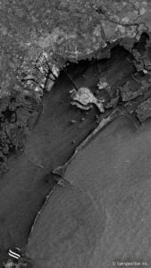
Synspective and Thaicom Partner on Disaster Response in Southeast Asia
Imagery startup Synspective and regional operator Thaicom are partnering to jointly offer synthetic aperture radar (SAR) for disaster response in Thailand. The two companies announced Tuesday they plan to offer […]
-
Imagery and Sensing
BlackSky Reseller Telespazio to Provide Disaster Response Imagery Service in Spain
BlackSky Technology reseller Telespazio Ibérica plans to offer a rapid emergency imagery service to a regional government in Spain, BlackSky announced on Tuesday. The deal will support the Government of […]
-
 Government/Military
NRO Expects RFP This Fall for Advanced Commercial Electro-Optic Capabilities
COLORADO SPRINGS, Colo.—This fall the National Reconnaissance Office (NRO) expects to issue its next request for proposals (RFP) under a commercial remote sensing effort for Innovative Commercial Electro-Optical (EO) capabilities, […]
-
 Government/Military
L3Harris to Build Weather Satellite Sensors for Japan
L3Harris Technologies will provide Japan Meteorological Agency (JMA) next-generation Geostationary (GEO) imaging and sounding instruments to monitor and predict severe weather events. L3Harris has a legacy of providing these space-based weather […]
-
 Government/Military
NASA Awards Capella Space Blanket Purchase Agreement for SAR Data
NASA has awarded Capella Space a blanket purchase agreement (BPA) for the company’s synthetic aperture radar (SAR) data, NASA announced Monday. This gives NASA five years to order Capella’s data, […]
-
 Government/Military
NRO Awards Options To 4 Commercial RF Satellite Companies
Aurora Insight, HawkEye 360, Kleos Space and Spire Global have each received contract options from the National Reconnaissance Office (NRO) to assess on-orbit capabilities under a prior contract the agency awarded the companies for […]
-
 Imagery and Sensing
Airline Industry Platform ch-aviation Taps Spire for Global Flight Analytics
Airline industry platform ch-aviation has a new long-term agreement with Spire Global for global flight analytics and insights, Spire announced April 6. The agreement includes access to Spire’s daily Flight […]
-
 Government/Military
NASA Awards Iceye 5-Year Blanket Purchase Agreement
NASA has awarded Iceye US a five-year blanket purchase agreement to buy the company’s synthetic aperture radar (SAR) data, Iceye announced Wednesday. This will give NASA centers broad access to […]
-
 Imagery and Sensing
Thales to Build 6 Satellites for Italy’s IRIDE Constellation
Thales Alenia Space has won a contract to build six satellites for the Italian Earth observation (EO) constellation IRIDE. The contract, awarded by the European Space Agency (ESA), is for […]
-
 Imagery and Sensing
Satellogic and SkyFi Partner for Satellite Tasking
Satellogic is partnering and integrating its data with SkyFi to allow SkyFi’s customers to task Satellogic satellites directly through its platform. The two Earth observation companies announced their partnership on […]
-
 Government/Military
BlackSky, Planet, Pixxel, and Others Win NRO Hyperspectral Study Contracts
The National Reconnaissance Office (NRO) has awarded six companies — BlackSky Technology, HyperSat, Orbital Sidekick, Pixxel, Planet, and Xplore — study contracts for commercial hyperspectral imagery. The NRO will use these study contracts […]
-
 Technology
Ubotica Releases New AI Solution to Aid Earth Observation Efficiency
Ubotica Technologies has unveiled a new solution to help in make Earth observation (EO) more efficient. It announced March 7, that it will bring its CogniSAT-CRC solution to market with […]
-
 Government/Military
Angola Orders Earth Observation Satellite from Airbus
Angola has ordered its first Earth observation satellite, Angeo-1, from Airbus Defence and Space. The satellite will be an Airbus S250 optical satellite. Terms of the deal, announced March 3, […]
-
 Imagery and Sensing
Ursa Space Systems Adds Kleos Space RF Data to its Platform
Kleos Space will join Ursa Space Systems’ “Virtual Constellation,” a database of satellite imagery from various imagery and sensing providers. Kleos collects radio frequency (RF) data through its satellite constellation. […]