First Light: Third SBIRS Successfully Transmitting Images

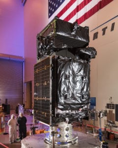
SBIRS GEO Flight 3 satellite. Photo: Lockheed Martin
From its final orbit location 22,000 miles above the equator, the third Space Based Infrared System (SBIRS) satellite recently sent its first images back down to Earth, a milestone known as “first light.” The satellite, built by Lockheed Martin, was launched on Jan. 20 aboard a United Launch Alliance (ULA) Atlas 5 rocket and is the third in a series of Geosynchronous Earth Orbit (GEO) satellites that the U.S. Air Force uses to provide faster and more accurate missile warning data to the nation and its allies.
The next-generation SBIRS ground station at Buckley Air Force Base, Colorado operates the constellation of satellites. GEO Flight 4, the next satellite in the series, will undergo final assembly, integration and test at Lockheed Martin’s satellite production facility in Sunnyvale, California, prior to its launch planned for later this year. The team is also working to modernize the fifth and sixth SBIRS satellites under a no-cost contract modification for the U.S. Air Force. Using a common, modernized A2100 spacecraft bus, the new design allows for a configurable payload module that can incorporate future sensor suites. The design will also save costs on production through a streamlined process, which enables concurrent testing of the satellite bus and payload, according to Lockheed Martin.