BlackSky’s 2025 financial performance was a mixed bag, with an increase in fourth quarter revenue and a 32% increase in backlog, despite an increase in the company’s net loss and...
Germany and Luxembourg-based sensing company Airmo will partner with satellite manufacturer EnduroSat to put its methane emissions monitoring technology into orbit, with the first satellite of a projected 12-satellite constellation...
Japanese satellite imagery providers Axelspace and Synspective finalized agreements with SKY Perfect JSAT, Mitsui, and Mitsubishi Electric to provide optical and synthetic aperture radar (SAR) imagery respectively to the Japan...
Loft Orbital is partnering with SmartSat Cooperative Research Center to demonstrate an AI-powered wildfire detection software on its satellites, the hosted payload operator announced on Wednesday. The mission is meant...
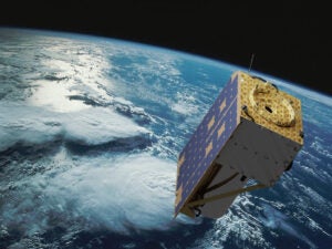
BlackSky Technology announced a deal with an unnamed international customer for a dedicated Gen-3 satellite, along with BlackSky’s imagery and analytics services. The deal announced Tuesday will give BlackSky’s international...
Planet Labs’ German subsidiary is partnering with a new arm of insurance firm AXA to integrate its Earth Observation data into an AI-powered risk management system to monitor and predict...
Software startup The Compression Company announced a $3.4 million pre-seed round of financing, led by veteran venture capital firm Long Journey, on Thursday. The Compression Company is focused on AI-driven...
The National Reconnaissance Office (NRO) on Tuesday said it has awarded contracts to HEO, SatVu and Sierra Nevada Corp. (SNC) to provide commercial satellite-based remote sensing capabilities, marking the first of three tranches of awards...
Sidus Space is teaming up with Simera Sense to develop next‑generation hyperspectral imaging solutions incorporating onboard data processing and analytics. The aim is to enable commercially deployable, intelligence‑driven Earth Observation...
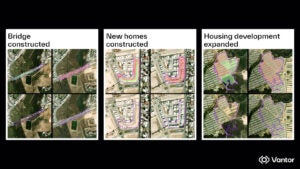
Vantor on Thursday said it received a $5.3 million contract from the National Geospatial-Intelligence Agency (NGA) to provide automated analytics on real-time changes in Earth’s terrain, helping the agency with its...