Latest News
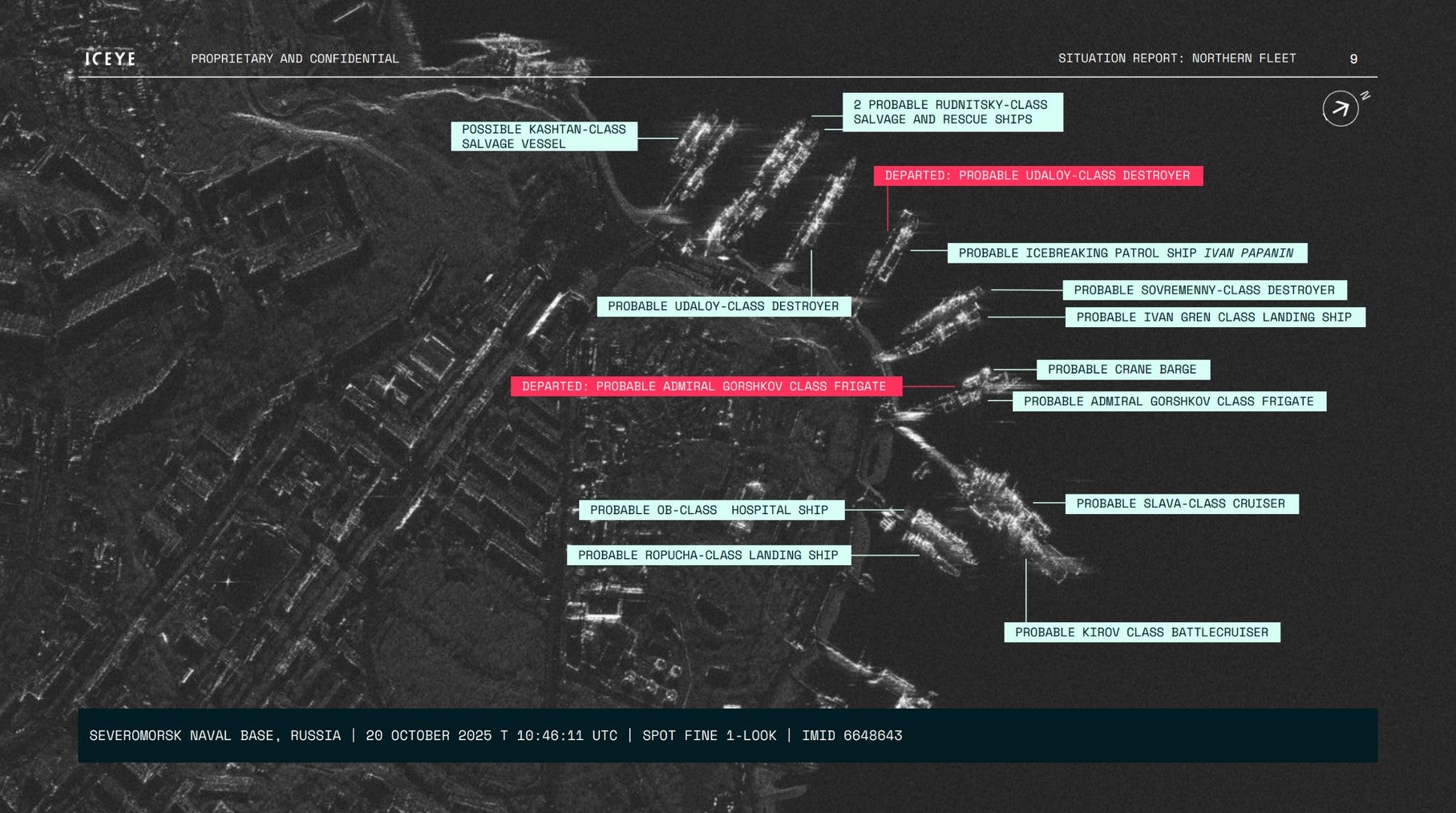
An Iceye internal situation report shows Russian vessels leaving Severomorsk Naval Base in Murmansk. Photo: Iceye
On a dark, clouded night, a Russian ballistic missile submarine departs a naval base in the Arctic. A small vessel navigates the Mediterranean Sea at 15 miles per hour. A tanker floats beside another to illegally receive a cargo of sanctioned oil.
The ocean is a big place covered by clouds and any of these activities are easy to miss. Iceye, a Finland-based Earth Observation firm, has tracked those three use cases from orbit, according to application studies provided to Via Satellite.
Its constellation of synthetic aperture radar (SAR) satellites, the largest in the world, is designed to monitor maritime activity in areas invisible to other observation methods.
Iceye US CEO Eric Jensen said that in areas with high cloud cover or short daylight, monitoring ships is made possible only by their obligation to transmit their locations. He said Iceye’s constellation is dense enough to provide high-revisit radar data in those areas.
The International Maritime Organization requires large ships to constantly broadcast their location via Automatic Identification System (AIS) beacons to coastal authorities and other ships, according to the IMO’s website.
“If it should happen that a ship either stops transmitting or it starts VPNing its transmission to some other location in the world instantaneously, which does happen, it’s now possible to nearly instantaneously verify what is in fact happening on that waterway by using radar-based collections,” Jensen told Via Satellite in an interview.
One such area is the Northern Sea Route, a seaway across the Arctic Ocean connecting the Barents Sea with the Bering Strait between Russia and Alaska. Climate change and shrinking Arctic Sea ice has made the route more feasible for commercial use.
An internal situation report provided to Via Satellite by Iceye demonstrates its imaging capability. The report includes three satellite images of Severomorsk Naval Base in Murmansk, Russia, on one end of the Northern Sea Route. The images provide an overview of the base across nine days in October 2025 and flag the departure of a probable Admiral Gorshkov-class frigate and probable Udalov-class destroyer.
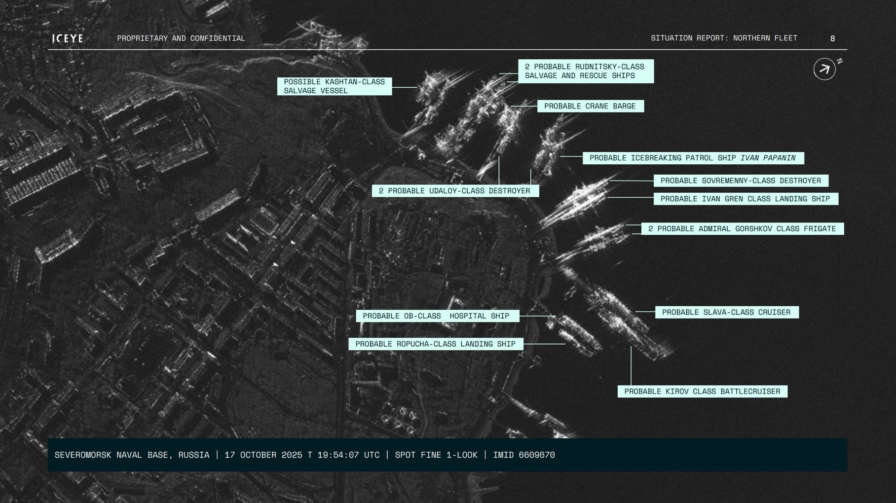
An Iceye internal situation report shows Russian vessels before they left Severomorsk Naval Base in Murmansk. Photo: Iceye
The Northern Sea Route is prime for illegal shipping because of its low visibility, an environment that Iceye’s radar sensors are adept at monitoring, Jensen said. A nation state could use Iceye’s solution to enforce sanctions on the route, he said.
“Throughout the winter months, you’ll have a significant amount of time that [the route is] embedded in darkness, and so it lends itself just environmentally to the context by which you could operate with nefarious ambitions,” Jensen said.
Iceye currently operates 70 satellites in orbit, having added six on SpaceX’s Transporter-16 rideshare mission last week. Jensen said no other company has a dense enough constellation to match the frequency of collection of Iceye’s data.
“We’re at a point in time where the density of our constellation is high enough where we have frequent revisits over high latitude locations, meaning several times per hour we may have a satellite flying over the same general area on ground,” Jensen said. “That is a new data layer that hasn’t existed before that nation states can tap into for their own benefit and maritime awareness.”
Iceye provides services for Western allied nations in civil, commercial, intelligence, and defense mission areas, Jensen said. Its clients include the U.S. Army, the National Reconnaissance Office, and NASA.
In January, Iceye expanded its services to Ukraine, which it has supported in its war with Russia since 2022. Western-aligned nations have heavily sanctioned Russia since it invaded Ukraine.
Jensen also cited a 2022 incident where Iceye satellites detected an apparent illegal transfer between two ships near the Stait of Taiwan. He didn’t know what was being transferred, but he knew the ships were from two countries that were sanctioned to not be working together, and that the confirmation gave the relevant decision-makers the confidence to respond.
Going forward, Iceye aims to expand production and further invest in its operating niche, Jensen said. In December, the company closed a $173 million funding round, valuing it at $2.8 billion.
Jensen said he hopes to see the Earth Observation industry use modern tools to generate more value. For example, improvements in computing could accelerate data relay in situations like disaster relief. He cited Iceye’s previous work with humanitarian organizations after Hurricanes Milton and Helene in 2024.
“We don’t have to go through this chain where it takes hours and hours and hours, potentially days, to give people information,” Jensen said. “We could potentially do it in minutes.”
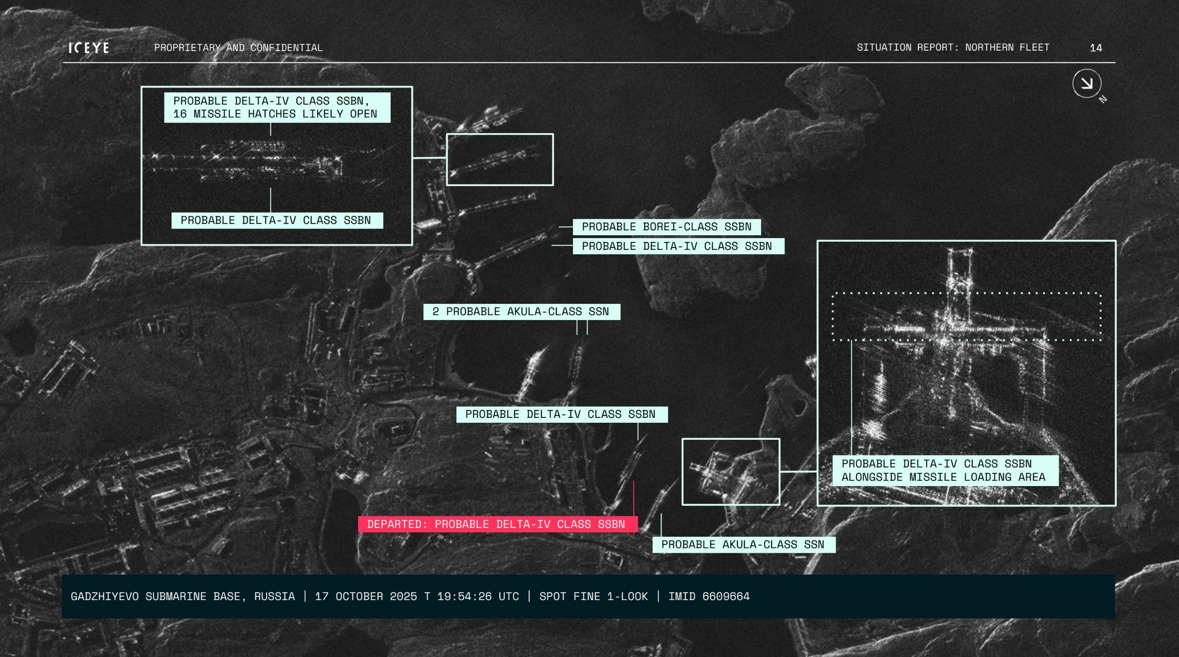
An Iceye internal situation report shows Russian vessels leaving Gadzhiyevo Submarine Base in Murmansk. Photo: Iceye
Stay connected and get ahead with the leading source of industry intel!
Subscribe Now