Latest News
Maxar Intelligence Launches ‘Vivid Features’ Vector Mapping with New Partner Ecopia AI
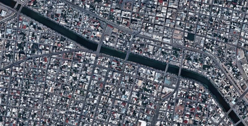
This visual shows these AI-powered interoperable vector features across Reynosa, Mexico, including the underlying satellite imagery basemap, 2D road centerlines and building footprints, and 3D building footprints. (Photo: Maxar)
Maxar Intelligence confirmed Wednesday that it is officially working in partnership with Ecopia AI to launch enhanced 2D and 3D global vector maps under the brand Vivid Features.
Vivid Features integrates Maxar’s satellite imagery captured by its constellation and automated spatial fusion software with Ecopia’s AI-based mapping system. The resulting new vector maps feature building footprints, road centerlines, and land cover anywhere on Earth, designed to revolutionize and accelerate modern map making. Maxar’s automated geospatial fusion software registers 30 centimeter-class imagery to the company’s global 3D foundation, with an accuracy of 3 meters.
The partners said in their announcement that Vivid Features is already delivering service to U.S. government, international government and commercial mapping customers, and has produced more than 1 billion building footprints around the world.
“Gaining an up-to-date, three-dimensional understanding of our planet and how it is changing is one of the most complex challenges our customers face,” said Jon Lipinski, president and co-founder of Ecopia AI. “While millions of square kilometers of satellite images are captured each day, many organizations struggle to develop corresponding 3D vector maps and keep them current to reflect real-world change. This partnership with Maxar will enable unprecedented access to up-to-date 3D vector maps across the globe.”
Stay connected and get ahead with the leading source of industry intel!
Subscribe Now