[Via Satellite 11-18-2015] Two Silicon Valley companies, Aquila Space and Astro Digital, are readying for the launch of a two-part, 30-satellite Earth observation constellation next year. The companies are designing a constellation known as Landmapper, comprised of 10 Broad Coverage (BC) satellites and 20 High Definition (HD) satellites to increase the supply of imagery available to customers that are currently users of Landsat data.
The Aquila Space-Astro Digital project is based on the exact spectral properties of Landsat, the joint NASA–United States Geological Survey (USGS) satellite program. But whereas Landsat collects fresh 30-meter imagery every 16 days, Landmapper will be sharper and more frequent.
As partners, Astro Digital is actively preparing for the massive amount of data anticipated from Landmapper. Aquila Space is building the small satellites, the first three of which are already slated for a Soyuz launch in the first half of 2016. The two companies plan to kick off services immediately once the first satellites are in orbit, which they started by planning the satellite design and the software in tandem.
“There’s a growing number of companies building applications and tools to make the management of farms more intelligent and put information at the fingertips of farmers, economists, seed companies, and consultants,” Bronwyn Agrios, head of product at Astro Digital, told Via Satellite. “Tying remote sensing data into that is an area where we are seeing a lot of traction, even with Landsat at a 16-day refresh.”
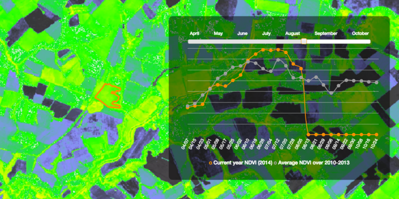
Early customers are already quite diverse, according to Chris Biddy, CEO of Aquila Space. He said Landmapper has a mix of more traditional users, along with newer data aggregators. Agrios said agricultural intelligence, such as understanding central yield for the entire United States corn belt, or the output of agricultural areas in Brazil, Europe, and elsewhere, is valuable data. Thus, agriculture is a big focus of Landmapper, which is designed to cover 40 million square kilometers of land per day with its BC satellites. HD spacecraft will cover 9 million square kilometers.
A big goal for Astro Digital is defining what the raw data processing pipeline will look like once the data hits the ground and gets to a point of being analytics-ready. Agrios said the company is working very closely with Aquila Space to find the best point at which data can be processed and work with the pixels to produce interesting information products.
“Our constellation is going to be producing probably about two terabytes of data a day, so it’s not a fire hose you can just turn on within an organization and have somebody start to work with,” she said.
In preparation, Astro Digital is already using Landsat data, is trying to include Moderate Resolution Imaging Spectroradiometer (MODIS) data from NASA, and is working with the European Space Agency (ESA) to start integrating Sentinel data, according to Agrios. To provide actionable insights, the company is developing software that can spot changes and notify customers when they happen.
“We enable people to identify areas of interest that they want to watch and also to define what about that area is significant. Then we watch that data coming in and process it, and if there is something that meets your significance threshold, such as a certain amount of change, then we send you an alert, a new map, and some values that we calculated from the pixels,” explained Agrios, adding that, while some people do want satellite imagery, their main focus is on creating information products.
For Aquila Space, Biddy said mirroring the properties of Landsat enables the company to instantly bring Landmapper data into existing workflows for people and infrastructure that were previously using Landsat.
“The initial platform is testing out this premise with Landsat data so that, as soon as our first satellites are in orbit, we can immediately plug in that data and add to that capability,” he said.
Landmapper is planned to launch in groups of two to four satellites over a three to four year timeframe. The BC satellites, with a 22-meter ground sampling distance, which launch first, followed by the 2.5 meter HD satellites. The companies will play off the strengths of specific satellites, such as revisiting locations of interest identified through the BC satellites later on with their sharper, but more narrowly focused HD brethren. Both Aquila Space and Astro Digital have done a lot of work on the front end to make sure their constellation is an early success. Even still, they are already contemplating longer-term plans for evolving the design.
“We came into this design making sure that our architecture was reconfigurable. That if we suddenly found there was so much demand for a particular data set and we need to expand it, we could easily do that by adding more satellites into the constellation,” said Biddy.
He said the satellites have a lifespan of five years, and while the first three lack propulsion, future spacecraft will include it. Biddy added they have carefully selected proper launches to reach their desired altitudes for sun-synchronous orbits in order to have decent lifetimes for the satellites.