Latest News
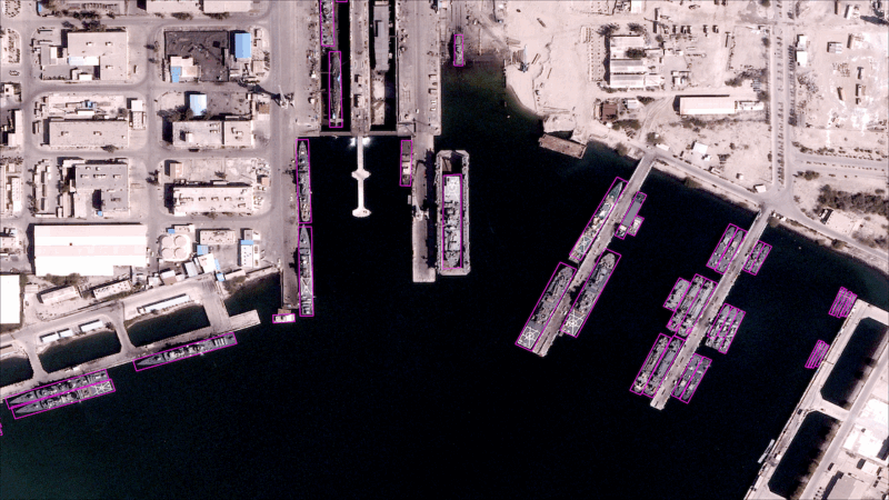
Automated vessel detection over Bandar Abbas in Iran, captured March 30, 2025, by BlackSky’s first Gen-3 satellite.
BlackSky is in the midst of rolling out its new Gen-3 satellites. After two launches, the company is demonstrating 35-centimeter very high resolution imagery, while ramping up the cadence of collection.
Via Satellite interviewed COO Nick Merski about the Gen-3 rollout, how the satellites are supporting new use cases for its customers with greater nuance in observation, and how AI underpins both the company’s analytics products and its workflows.
VIA SATELLITE: Congratulations on the Gen-3 satellite launches. It’s fascinating to see the clarity in the first images from the satellites. Can you put into context how much of a leap forward Gen-3 is, and what that means for BlackSky’s customers?
Merski: It’s a gratifying moment to see something that we’ve been focused on for several years come in and exceed our expectations. It is a significant leap forward. Our Gen-2 constellation was built to detect the presence of a thing — whether it’s a car or a ship, etc. Gen-3 enables so much more depth. You can look at more nuanced activity around the presence of an object. For instance, you can tell the difference between a box truck and a tractor-trailer or distinguish between pickup trucks, jeeps and passenger vehicles, and then see patterns over time to help you understand why those vehicles are where they are. It unlocks many more applications for BlackSky, as we run analytics on the imagery, and for our users, as they do exploitation on the imagery and analysis. It’s a powerful step forward for us.
VIA SATELLITE: With four more planned to launch this year, how will the Gen-3 constellation increase the speed at which BlackSky is delivering insights to its customers?
Merski: We talk about speed a couple of different ways. As we add more satellites, we’re increasing the number of observations over a location from daily to intra-day and working up to hourly, just like we did with our Gen-2 constellation. The speed between one look to another look is going to continue to increase linearly as we bring more satellites online. We will start with the general availability of our service in September, and as we get to six satellites and beyond, we’ll give customers even more access.
With Gen-3, we are also building trust with our customers that we can scale as a service. We don’t want them to wait a long time from when we launch a satellite to when it’s available. We’ve always tried to build satellites such that it’s just another input that we can add to the network. When a sensor comes online, it behaves just like any other and immediately starts adding observations. That’s one of the things that we’re proud of from the initial Gen-3 launch. For the first satellite of this generation, we saw imagery inside of five days and started sharing it with our customers in the first month. We expect to bring those timelines down and use the next launches to build even more trust and reliance on our services.
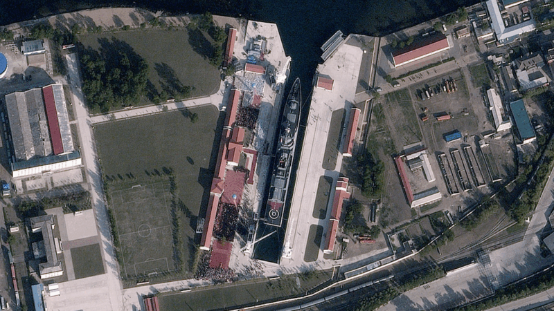
Launching ceremony for North Korea’s Kang Kon destroyer at No. 28 Shipyard Rajin, captured June 12, 2025, by BlackSky’s first Gen-3 satellite.
VIA SATELLITE: Beyond the investment in space-based capabilities, how is BlackSky investing in evolving the analytics platform and its product offerings?
Merski: We take a holistic view on this. It’s not just about bringing down an image; it’s about handing our customers insights as quickly as possible. We don’t think of the satellite and the analytics independently. We have a highly coupled roadmap. We train the analytics by anticipating the data quality so that ready to plug the analytics in as soon as a new satellite is collecting data. You’ll see a steady cadence of analytics offerings following imagery services from Gen-3.
VIA SATELLITE: You mentioned that Gen-3 can unlock new applications for your customers. What are some examples of what those new applications could be?
Merski: If you think about running analytics on a single image — whether that’s motion and vector detect, whether that’s cars, airplanes, ships, and doing both detection and classification — in a 20-kilometer scene, depending on the geometry, we’re capturing 50 to 70,000 objects. At times, it’s in a dense urban setting with multiple ports and roads. The use cases become almost endless when you combine that with the additional resolution. Is there a traffic jam? You can see an obstruction in the road that wasn’t there an hour ago. These new use cases emerge from ‘presence of’ to understanding of what changed. Port entry and exit, looking at detailed information about load/offload of ships. The way that cargo is being staged for airplanes. That’s the fun part — it puts the power in the user’s hand. It allows for detailed exploitation and lets them continue to find new applications.
VIA SATELLITE: BlackSky has had a number of wins on the international side and CEO Brian O’Toole has talked about the prevalence of international demand. What is driving that demand from international customers, and how does BlackSky ensure it can meet the needs of the international governments?
Merski: People realize the power of what geospatial services can bring to their operational picture, whether it’s intelligence or tactical support. Organizations are maybe buying differently at a time when there are more options. They’re really looking at what an initial subscription-based service can bring, and then what custom capability they want to add to that, and how they want to consume it.
We try to meet customers in a valuable “1 + 1 = 3” conversation where activating a subscription gives customers same-day, immediate access to capability, and then we explore their interests in on-orbit assets that they want to own and hold custody over. In this dynamic, we discover which sets of services they see value in. We combine those into a workflow that integrates easily with their operational processes. We’re meeting the market with customer-focused flexibility. I think that’s why you’re seeing that demand continue to grow.
VIA SATELLITE: How would you describe U.S. government demand right now? Are there any changes BlackSky would like to see in how the U.S. government acquires commercial imagery?
Merski: We’ve got a long-standing relationship with the U.S. government, which has been buying services like what we provide for decades now. To meet their operational needs, we must build ahead. We’re communicating on not just what their needs are now, but what they are years out, and building a plan around where they’re going. The thing we’d always appreciate is a better line of sight to that. Gone are the days where services are paid for in advance. They’re paid for as we bring the capability to the market. The more precision we can get on that demand signal, the better.
VIA SATELLITE: BlackSky’s software and analytics is a large part of what sets the company apart. What role does AI play beyond applying it to satellite imagery?
Merski: When we started the company, we had a strong vision for full automation from the onset. That means no human in the loop from when an order is presented to when data is delivered. AI is a massive tool for making that level of automation possible, whether it’s looking at satellite telemetry or assuring the quality of images. It’s a central part of how we’ve built the latency and the service characteristics that we have. It’s something that we’re going to continue to invest in and find new avenues to help us be even more efficient in the future.
And when I say that we have no one in the loop from when an order is placed to when it is delivered, I truly mean there is no one in the building. We don’t have an operator standing in our mission operations center (MOC) waiting for something to go wrong. When something does go wrong, we use AI and automation tools to evaluate what went wrong to see if the system can correct itself. Only after it goes through the process would an operator be asked to intervene. The MOC is truly “lights out,” and you can talk about that at every stage. In mission planning, we’re taking tens of thousands of requests for different images and optimizing them in space and time continuously. All of that happens without any human orchestration.
VIA SATELLITE: Do you see a greater opportunity for Earth observation companies to work together on sensor fusion and bringing different types of sensors together like electro optical, SAR, RF, hyperspectral?
Merski: Absolutely. In the pursuit of complete answers, different types of information act as collaborative puzzle pieces for answering different questions. We’re starting to see some this affect how customers contract for services. They are not necessarily contracting for an image and going somewhere else to get an answer. They’re asking companies to come together and collaborate to get that answer. In terms of opportunities to improve, I think we all can work to share our information more rapidly, to get it into workflows to make it easier to consume. That’s something BlackSky has been focused on for a long time with our BlackSky Spectra platform. We have had the ability to integrate other companies’ data since we brought the platform online 10 years ago, and we will continue to be a hub. Wherever a customer needs the information, we can get it there and it can be fused in the right places, which is key.
VIA SATELLITE: Last year, BlackSky acquired the full stake in manufacturing joint venture LeoStella. What has having full ownership of LeoStella meant for BlackSky’s satellite production?
Merski: As we go about increasing scale, reliability, and moving Gen-3 from a daily service to an hourly service, full ownership of LeoStella allows us to be more predictable in how and when we can do that. That helps give customers the confidence that we will be there when we need to be there for them. If we see an opportunity to improve something, we can do it, make sure it works, and bring it to our customers faster. It has benefits for both predictability and speed of innovation.
VIA SATELLITE: What does the rest of this year look like for BlackSky ramping up Gen-3?
Merski: We have our hourly monitoring service with Gen-2 and we’re introducing a daily service with Gen-3. The first part of the year was showing that Gen-3 works. The technical maturity of Gen-2 played a big part in that success. And now it’s about showing customers the combined power of both – sustained monitoring over multiple locations with Gen-2 and very high-resolution Gen-3 imagery for a deeper dive into the details.
Stay connected and get ahead with the leading source of industry intel!
Subscribe Now