
Imagery and Sensing
-
 Launch
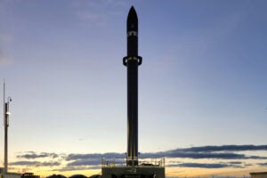
Rocket Lab Launches Mission for HawkEye 360 With Experimental Satellite
Rocket Lab launched four satellites for HawkEye 360, including three radio frequency (RF) tracking satellites and one experimental satellite. The mission took place early morning on Friday, June 27 from […]
-
 Imagery and Sensing
Maxar Releases Geospatial Monitoring Solution For Predictive Intelligence
Maxar Intelligence on Wednesday announced a new solution suite that applies artificial intelligence-enabled analytics to geospatial imagery for persistent global monitoring of fixed sites and vessels on the open sea to […]
-
 Government/Military
NGA Awards BlackSky Potential $24M Luno A Task Order for AI-Based Analytics
BlackSky Technology has received a potential $24-plus million task order to provide the National Geospatial-Intelligence Agency (NGA) with object detection monitoring of military and economic facilities worldwide. The initial award […]
-
 Imagery and Sensing
SatVu to Work With 5 Partners on NGA’s Luno A & B Programs
SatVu will support the National Geospatial-Intelligence Agency’s (NGA) Luno A & B programs by partnering with five other companies to provide its thermal imagery. SatVu, based in the United Kingdom, […]
-
 Government/Military
Remote Sensing CEOs Call Out Risks of Potential Budget Cuts
A group remote sensing CEOs outlined the risks that come with potential budget cuts to commercial imagery programs in a letter to Congressional leaders. Iceye U.S. publicly shared the letter on […]
-
 Imagery and Sensing
BlackSky to Expand Constellation With Multispectral, Large-Area Satellites
BlackSky is planning to expand the capabilities of its Earth Observation (EO) constellation with multispectral, large-area collection satellites called AROS, to launch “as early as 2027.” BlackSky explained the AROS […]
-
 Government/Military
Planet Wins New NATO Intelligence Deal
Planet has signed a new seven-figure contract with NATO to deliver advanced daily monitoring and intelligence capabilities across NATO’s strategic areas of interest. Planet called it a “landmark partnership” and […]
-
 Imagery and Sensing
Portuguese Air Force Taps ICEYE for SAR Satellite
ICEYE has made inroads into Portugal with a breakthrough SAR satellite deal. The Portuguese Air Force, a branch of the Portuguese Armed Forces is purchasing one ICEYE SAR satellite, a […]
-
 Imagery and Sensing
BAE Systems and Hanwha Systems to Collaborate on Multi-Sensor Satellite System
BAE Systems and Hanwha Systems have signed a new MoU to develop a multi-sensor satellite system to collect radio frequency (RF) and synthetic aperture radar (SAR) data. Announcing the MoU […]
-
 Imagery and Sensing
Tomorrow.io Teams up with National Irrigational Administration for AI Weather Prediction Project in the Philippines
Low-Earth orbit satellite global weather intelligence provider Tomorrow.io will partner with the National Irrigation Administration (NIA) to help farmers adapt to climate change and boost productivity using Artificial Intelligence in […]
-
 Imagery and Sensing
Iceye and IHI to Develop SAR Constellation in Japan
Iceye plans to develop a synthetic aperture radar (SAR) constellation with Japanese heavy industry company IHI Corporation under a new MoU announced Thursday. IHI and Iceye plan to establish a […]
-
 Government/Military
NGA, Space Force Agree On Roles And Responsibilities For TacSRT
ST. LOUIS — The National Geospatial-Intelligence Agency (NGA) and the U.S. Space Force on Wednesday signed a memorandum of agreement (MoA) clarifying their respective roles and responsibilities in carrying out […]
-
 Government/Military
NGA Close to Operational Use of New GEOINT Tasking Tool for Combatant Commands
ST. LOUIS — A new version of the National Geospatial-Intelligence Agency’s (NGA) primary tool for ordering imagery should be ready for operational use later this year, an agency official said. […]
-
 Imagery and Sensing
UK’s Space Eye Ready to Revolutionize Water Leakage Detection
Space technology could be used going forward to detect water leakage throughout the U.K. thanks to an interesting new project called ‘Space Eye.’ Researchers at the University of Wolverhampton, alongside […]
-
 Imagery and Sensing
Commercial Satellite Imagery Leaders See Increased International Demand
ST LOUIS — Commercial satellite imagery and sensing leaders see growing demand in the international market for geospatial intelligence and are looking at ways to increase collaboration and streamline the way […]
-
 Government/Military
Key Geospatial Intel Lesson of Ukraine War Is Closing Kill Chain, NATO Official Says
ST. LOUIS — The use of geospatial intelligence to accelerate decision making from the time a potential target has been detected until an effect is put against it has been […]
-
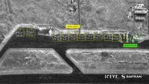 Imagery and Sensing
Iceye Enters New Geospatial Intelligence AI Tech Partnership with Safran.AI
Satellite data imagery company Iceye entered into a long-term strategic partnership with Safran.AI to develop advanced multi-sensor Artificial Intelligence (AI) solutions for geospatial intelligence customers in the government sector. The partnership, […]
-
 Government/Military
Muon Space Advances to Stage II on NRO Contract for Commercial Electro-Optical Imagery
Muon Space has won further business from the National Reconnaissance Office (NRO). The newly awarded contract stage will continue to develop the national security potential of multispectral electro-optical and infrared […]
-
 Imagery and Sensing
Iceye Expands Disaster Response Solutions for Utility and Energy Sectors
Iceye is now supporting the utility and energy sectors with its disaster response solutions. Iceye plans to offer utilities and energy organizations the ability to access near real-time natural disaster […]
-
 Imagery and Sensing
Iceye Continues European Expansion With Rheinmetall JV and Manufacturing Center in Spain
Iceye has made key moves in Germany and Spain as it continues to grow its presence in Europe. In Germany, it has signed an MoU with German defense manufacturer Rheinmetall […]
-
 Imagery and Sensing
Planet to Supply Imagery to German Government for Land and Water Management
Planet Labs Germany, part of the Planet Group, signed government deal in Germany as the German government looks to improve its water and land management from space. Planet signed a […]
-
 Imagery and Sensing
OroraTech Readies for US Expansion with New Denver Headquarters
OroraTech is hoping to make its presence felt in the U.S. market after opening its U.S. headquarters in Denver. The company, whic is based in Germany and specializes in wildfire […]
-
 Government/Military
Poland Invests in 3-Satellite EO Constellation Built by Creotech Instruments
Polish space company Creotech Instruments will build three Earth observation (EO) satellites for Poland under a new contract with the European Space Agency (ESA) announced April 15. The contract is […]
-
 Manufacturing
Sidus Space, Little Place Labs Unveil New Maritime Intelligence Capabilities for the LizzieSat Platform
Sidus Space rolled out near real-time vessel detection and classification capabilities for its LizzieSat space-based maritime intelligence satellite platform. Sidus’ 3D printed LizzieSat can now process data directly onboard through […]
-
 Imagery and Sensing
EarthDaily Analytics Set for Summer Launch After Integrating Payload on Loft Orbital’s Longbow Satellite
Earth observation company EarthDaily Analytics and its engineering partner ABB integrated the first EarthDaily constellation satellite payload with one of Loft Orbital‘s Longbow satellite buses and completed spacecraft-level environmental testing. […]
-
Finance
D-Orbit Acquires Italian EO Company Planetek
Space logistics company D-Orbit announced a deal on Friday to acquire Italian Earth Observation (EO) and analytics company Planetek Group to bring together in-orbit servicing and space data. D-Orbit has […]
-
 Imagery and Sensing
Thales Alenia Space Wins Contract for Systems Upgrades for EGNOS
Thales Alenia Space has won a new contract worth 51 million euros ($55.1 million) with the European Union Agency for the Space Programme (EUSPA) to extend the operational life of […]
-
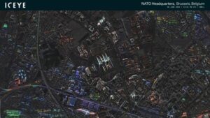 Imagery and Sensing
Iceye Provides SAR Satellite Data to NATO Situation Center
Iceye announced Friday it will provide satellite data to the Situation Center at NATO HQ (SITCEN). The collaboration will give SITCEN access to Iceye’s capabilities, which Iceye said will enhance […]
-
 Imagery and Sensing
Maxar Debuts Raptor Software That Uses 3D Data for Drone Positioning
Maxar Intelligence has a new software offering called Raptor that uses the company’s 3D terrain data to allow autonomous drones to navigate environments without GPS. Maxar announced Raptor on Tuesday, […]
-
 Imagery and Sensing
Planet Labs Signs Contract with ESA to Support Greek National Space Services
Planet Labs signed a contract with the European Space Agency (ESA) on behalf of the Hellenic Ministry of Digital Governance to support the Greek National SmallSat Program, Planet announced on […]