
Imagery and Sensing
-
 Imagery and Sensing
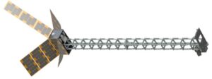
Open Cosmos to Build 3 Satellites for ESA to Monitor Earth’s Magnetic Field
Open Cosmos won a 35 million euro ($37 million) contract from the European Space Agency (ESA) to build three satellites to monitor Earth’s magnetic field in the NanoMagSat mission. The […]
-
 Imagery and Sensing
Hungary’s 4iG Plans HUSAT Satellite Program
Hungarian telecommunications company 4iG plans to launch Earth observation satellites and a telecommunication satellite in the HUSAT program. In a Nov. 20 announcement, 4iG called HUSAT the “largest privately funded […]
-
Finance
Spire to Sell Maritime Business to Kpler in $241M Deal
Spire Global plans to sell its maritime business to Kpler in a $241 million deal that will pay off all of the company’s debt. Kpler is a data and analytics […]
-
 Sustainability
Architecture Firm Looks to Satellite Data for More Resilient Urban Planning
Hungarian architectural firm Paulinyi & Partners is using satellite technology to improve its work in urban planning and says this collaboration can lead to more climate-resistant designs. In late 2023, […]
-
 Imagery and Sensing
New Remote Sensing Firm Matter Intelligence Raises $12M Seed Funding
A new remote sensing startup Matter Intelligence emerged from stealth mode on Wednesday with $12 million in seed funding. The startup aims to capture hyperspectral data of “all matter on […]
-
 Imagery and Sensing
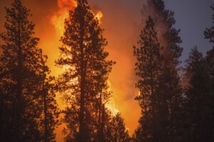
Spire Global and OroraTech Win NASA Contract for Wildfire Monitoring
NASA‘s Jet Propulsion Laboratory awarded Spire Global a contract to develop space-based capabilities for wildfire early detection and active monitoring. Spire announced the award on Tuesday and said the company […]
-
 Government/Military
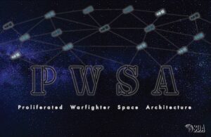
Umbra Lands SDA Contract to Explore Integrating Remote Sensing in PWSA
Umbra has been awarded a multi-million dollar contract by the Space Development Agency (SDA) to demonstrate the feasibility of integrating its commercial remote sensing capabilities into SDA’s Proliferated Warfighter Space […]
-
 Imagery and Sensing
ESA Orders More Satellites for Italy’s IRIDE Constellation from Thales, Argotec
The European Space Agency (ESA) ordered six more satellites from Thales Alenia Space and 15 satellites from Argotec for the Italian Earth observation IRIDE constellation. IRIDE is an Italian government […]
-
 Finance
OroraTech Raises $27M to Further Wildfire-Detection Constellation
German wildfire-detection startup OroraTech raised 25 million euros ($27 million) in a Series B funding round to build out its predictive AI capabilities and orbital sensor network. OroraTech announced the […]
-
 Imagery and Sensing
EarthDaily Acquires Descartes Labs
EarthDaily Analytics has acquired geospatial intelligence firm Descartes Labs, the company announced Tuesday. EarthDaily Analytics said the acquisition was attractive because of how Descartes Labs products apply geospatial data to […]
-
 Imagery and Sensing
Carbon Mapper Shares the First Emissions Detection Images from CO2-Tracking Satellite
Greenhouse gas monitoring nonprofit Carbon Mapper released the first images of emission detection from the Tanager-1 satellite on Thursday, showing methane plumes from energy plants. These first methane detection images […]
-
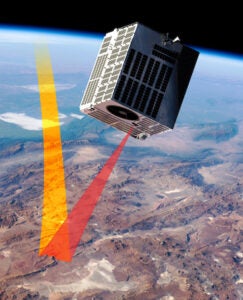
 Imagery and Sensing
BlackSky Expanding in to Space Domain Awareness With New Contract
BlackSky is expanding into space domain awareness (SDA) with a new contract to support an unnamed customer to deliver non-Earth imaging (NEI). Instead of providing satellite imagery of Earth, BlackSky […]
-
 Imagery and Sensing
Planet Data Used for Sugarbeet Crop Monitoring in New Agriculture Contract
Planet’s satellite data informs sugarbeet crop monitoring under a new contract between Planet partner SatAgro and American Crystal Sugar Company. Sugarbeet is a root crop with a high concentration of […]
-
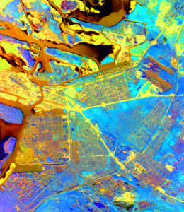
Imagery and Sensing
Iceye Debuts 25 cm SAR Imagery Resolution
Iceye now has the capability to offer 25 cm resolution for its synthetic aperture radar (SAR) imagery. The new feature announced Wednesday is called “Dwell Precise” and it is based […]
-
 Sustainability
Planet Debuts Forest Carbon Monitoring Product to Inform Carbon Markets
Planet has released its Forest Carbon Monitoring product, a new quarterly dataset for monitoring forest growth and change. The company said this data will help establish voluntary carbon markets and […]
-
 Imagery and Sensing
Maxar Intelligence Opens New London Headquarters to Boost International Presence
Maxar Intelligence opened a new London office this week as the headquarters for its international government business as it aims to increase its global presence. The London office will also […]
-
 Imagery and Sensing
Amini Launches Amini Lite Data Platform in Africa
Amini has unveiled details of a key new product launch as it looks to bring the power of satellite tech to its customers, mainly farmers across Africa. It is launching […]
-
 Imagery and Sensing
Starshield’s Shadow Now Looms Over the EO Market
PARIS — SpaceX’s Starshield now looms large over the Earth observation (EO) market as industry players look to grow revenues in a market that has not always lived up to […]
-
 Imagery and Sensing
Lockheed Martin to Develop Lightning Mapper for NOAA GeoXO Satellites
NASA awarded Lockheed Martin a contract to design and build the next-generation GeoXO Lightning Mapper (LMX) instruments for the National Oceanic and Atmospheric Administration (NOAA) GeoXO satellites. The baseline contract […]
-
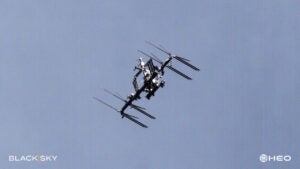 Imagery and Sensing
BlackSky Signs 7-Figure Deal With HEO to Collect Imagery of Objects in Space
BlackSky was awarded a seven-figure contract by HEO, an Australian startup specializing in non-Earth imaging (NEI) and analytics. BlackSky will provide imagery of objects in space for space domain awareness, […]
-
 Imagery and Sensing
NGA Selects 10 Vendors to Compete Under $290M Luno A Global Monitoring Program
The National Geospatial-Intelligence Agency (NGA) selected 10 companies to compete for task orders under a potential five-year, $290 million contract seeking commercial data and analytic services that monitor and assess […]
-
 Imagery and Sensing
Synspective CEO Motoyuki Arai on the Japanese SAR Provider’s Plans to Scale
Japanese startup Synspective has had a busy summer as the synthetic aperture radar (SAR) company ramps up its constellation deployment. In June, Synspective announced a $44 million Series C round, […]
-
 Imagery and Sensing
Iceye Wins Greek Government Deal for Sovereign SAR Satellites
Iceye will see its persistent monitoring, and natural catastrophe solutions used in Greece thanks to a new contract win. It has signed a contract for the Greek National Satellite Space […]
-
 Imagery and Sensing
NASA Selects 8 Companies for Commercial SmallSat Services
NASA has selected eight companies to provide commercial satellite data to support the agency’s Earth science research. NASA announced the Commercial SmallSat Data Acquisition Program On-Ramp1 Multiple Award contract on […]
-
 Imagery and Sensing
Iceye Expands Satellite Data Licensing Agreement with Insurance Firm Aon
Iceye is making further inroads into the lucrative insurance market. Aon, a global professional services firm, has expanded its data licensing agreement to include Iceye’s Flood Insights data globally and […]
-
 Launch
Europe Says Goodbye to Vega Rocket in Copernicus Mission
Arianespace launched the final mission for the original Vega rocket on Sept. 4, launching the Copernicus Sentinel-2C satellite. Vega was in service for 12 years with 20 successful flights. It […]
-
 Finance
BlackSky Executes Reverse Stock Split to Raise Share Price
Satellite imagery company BlackSky will execute a reverse stock split to raise its share price, the company announced Wednesday. BlackSky’s shareholders approved the 1-for-8 reverse split during an annual meeting on […]
-
 Imagery and Sensing
Telespazio to Establish Italian GNSS Center
Telespazio will play a key role in an ambitious new space project in Italy which will see the creation of Italy’s first national center for the development of satellite navigation […]
-
 Manufacturing
Nuview Selects Space Flight Laboratory to Develop Pathfinder Bus
Nuview has selected Space Flight Laboratory (SFL) to develop the pathfinder satellite bus for its LiDAR demonstration satellite. Nuview, which emerged from stealth mode in 2023, plans to build the […]
-
 Imagery and Sensing
Planet Labs Wins EO Data Contract with Germany’s UP42
Berlin-based UP42 is joining forces with Planet Labs to improve the data offerings it can offer customers on its an Earth Observation (EO) platform. This collaboration aims to significantly expand […]