EOMAP CEO Leveraging Earth Observation Capabilities with Great Barrier Reef Map
An EOMAP 3-D Image from the Great Barrier Reef. Photo: EOMAP
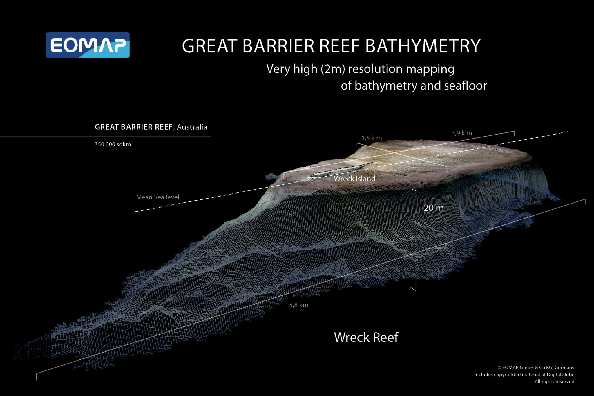
[Via Satellite 12-05-13] The recently released 3-D map of the Great Barrier Reef created by the German company EOMAP in conjunction with James Cook University in Australia is one of the more unique projects in the Earth Observation arena. The map covers approximately 350,000 square kilometers at 30-meter horizontal resolution. With this project, EOMAP hopes to send a signal to the market about its ambitions that is as clear as its imaging.
“Not all people and organizations are fully aware of the capabilities [of Earth Observation],” said Thomas Heege, CEO of EOMAP. “When I founded the company there seemed to be a niche in this market and indeed you will not find many EO companies working in this field. The Great Barrier Reef was a good area – well known worldwide – to start with just to get more attention.”
EOMAP is a spinoff of the German Aerospace Center and was supported by the European Space Agency’s (ESA) Business Incubation Center in Bavaria. Mapping the Great Barrier Reef was a strategic demonstration project; it’s waters have been difficult to chart due to the size and complexity of the reef, making it a hazard to ships and difficult for conservation efforts. Using LandSat 7, EOMAP was able to map the surface underneath the water, a process known as bathymetry, at a previously unreached level of detail.
“The process to derive bathymetry is called a physics-based process. That means we use satellite imagery not as imagery and then do some empirical relations to derive certain parameters, but we take up the calibrated satellite images,” explained Heege.
EOMAP’s Modular Inversion and Processing System (MIP), used for satellite-based observations, includes corrections for sun glitter, water depth and albedo from the sea floor and nearby coastlines. The company has traditionally taken projects on an individual basis, but now it hopes to shift from working on a case-by-case schedule to an off-the-shelf method.
“The Great Barrier Reef was one of our first larger areas where we did not work just on behalf of a certain project demanded by a client, but as a demonstrative project,” said Heege. “We expect that for the Great Barrier Reef and other regions worldwide, that if you create the product already, it is much easier for interested users and clients to take it up in the process.”
Most of EOMAP customers come from energy and government markets, which find the company’s bathymetry products particularly useful. “We have industries, for example Shell, or BP or Woodside energy [as customers]. We’ve done contracts for them so they’ve already [experienced] significant savings from bathymetry,” said Heege. “We also have governmental [customers] and for the Great Barrier Reef we expect both sides [to be interested], but initially I think we expect more government take-up because it is a national park.”
Geographies, naturally, play a big part in determining the type of customer. “It depends on the region,” said Heege. “On some regions we have more industrial users; in others, more governmental. In Mexico, we mapped the whole Yucatán coastline down to Belize, for an environmental industry. In the Caspian [Sea] it’s industrial and in the Arabian [Sea] it’s a mix.”
Mapping the Great Barrier Reef marks a turning point from which EOMAP hopes to support future demands with an existing suite of products. “We will have many areas of the work in our off-the-shelf database so clients can directly go and get the bathymetry products they need,” said Heege. The company works with a variety of EO satellite operators including ESA, RapidEye and DigitalGlobe to collect bathymetric observations. EOMAP has used DigitalGlobe’s WorldView 2 satellite and NASA/USGS’s Landsat 7 and Landsat 8 satellites for high quality 2-meter resolution mapping in the past. Now the company is readying itself for the Sentinel 2 satellites, in development by ESA, to provide more complete coverage. EOMAP is working together with the German Aerospace Center and ESA to build the infrastructure necessary to use Sentinel 2.
“Quickbird (a DigitalGlobe satellite) is getting a little older now and the calibration is not as stable. As we see more well calibrated satellites available we can implement them to make more area available,” said Heege. “[Today our] satellite coverage is not yet good enough so we simply don’t have worldwide coverage of the capable areas. This will significantly increase awareness, and we will have a much better worldwide coverage, which we cannot have yet.” From there the company will be able to create a large enough off-the-shelf index, and will use it as the primary method of selling EO data.