DigitalGlobe Launches SecureWatch for Defense and Intelligence Customers
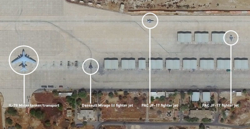
Demo image for SecureWatch. Photo: DigitalGlobe.
DigitalGlobe announced the launch of a new product, SecureWatch, optimized for international defense and intelligence customers. SecureWatch is a web-based subscription service that gives intelligence agencies and defense organizations access to DigitalGlobe’s 7 billion sq. km. imagery library and millions of square kilometers of daily image collections. SecureWatch capabilities are designed with the flexibility to evolve to meet a growing market demand for a single platform that fuses multi-source geospatial intelligence content including satellite imagery at various resolutions and refresh intervals, geographic information system layers, tactically significant news stories, timely social media posts, real-time transportation data, and more.
Images from the complete constellation of DigitalGlobe Earth observation satellites, including WorldView-4 (30 cm), WorldView-3 (30 cm), WorldView-2 (46 cm), GeoEye-1 (40 cm), WorldView-1 (50 cm) and legacy satellites, are available through SecureWatch. Customers can view imagery anywhere on the globe at high resolution, simply using a web browser. Subscribers can also stream images to preferred image exploitation software such as Esri ArcGIS and Textron RemoteView, or they can download for use in offline workflows.
In addition to accessing imagery, the tools included with a subscription to SecureWatch enable a variety of intelligence workflows. With just a web browser and internet access, users can accurately measure coordinates, create annotated image graphics for reports and briefings, produce videos that show how areas have changed over time, and remotely view imagery from a smartphone or tablet when working in the field.