Eyes in the Sky: Satellite Images of Hurricane Harvey
Hurricane Harvey has already dumped the highest total rainfall from a hurricane in the continental U.S. at a record 49.32 inches — and the storm will continue to rage through the end of the week. Here, we’ve collected some awe-inspiring satellite images of one of the worst hurricanes in American history.
1) NASA astronaut Randy Bresnik shares his perspective from the International Space Station (ISS).
God Bless Texas, may you weather the storm as you always have! pic.twitter.com/8qXHXc8YMY
— Randy Bresnik (@AstroKomrade) August 24, 2017
#Harvey – still a menace! Hearts & prayers go out to families, friends, & fellow Texans dealing with this storm. #TexasStrong #HoustonStrong pic.twitter.com/6E4otEWF6x
— Randy Bresnik (@AstroKomrade) August 28, 2017
2) The National Oceanic and Atmospheric Administration’s (NOAA) GOES 16 satellite captured this geocolor image of Hurricane Harvey in the Gulf of Mexico on Aug 24, 2017.
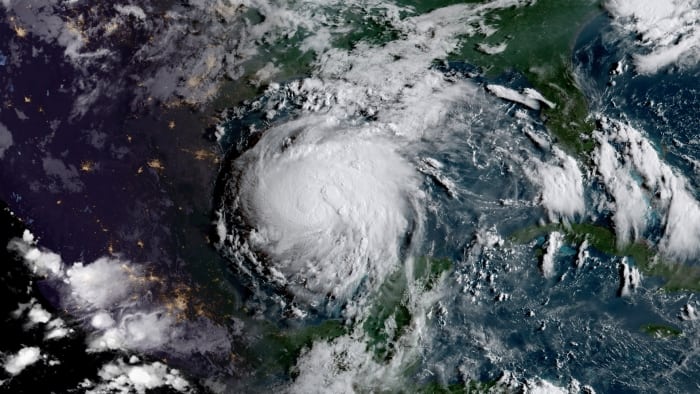
Photo: NOAA.
3) GOES 16 captures Harvey’s progression from Aug. 25 to Aug 27.
GOES East satellite imagery over past 3 days showing #Harvey moving into #Texas. Get the latest at https://t.co/CucSBvXDAQ and stay safe! pic.twitter.com/mNHDU5fY32
— NOAA Satellites (@NOAASatellites) August 27, 2017
4) This GOES 16 visible/infrared loop shows Hurricane Harvey’s outer rainbands reaching the Texas coast.
This #GOES16 visible/infrared loop shows #Harvey‘s outer rainbands reaching the #Texas coast. Latest information @ https://t.co/cSGOfrM0lG pic.twitter.com/Y6WXQho8a8
— NOAA Satellites (@NOAASatellites) August 25, 2017
6) Additional imagery of Hurricane Harvey as seen from the ISS.
.@Astro2fish orbited over Hurricane #Harvey2017 and photographed the storm bearing down on the Texas coast. pic.twitter.com/eBzNc7NlMZ
— Intl. Space Station (@Space_Station) August 25, 2017