DMCii CEO: Comfortable Level of EO Satellites at Least Five Years Away
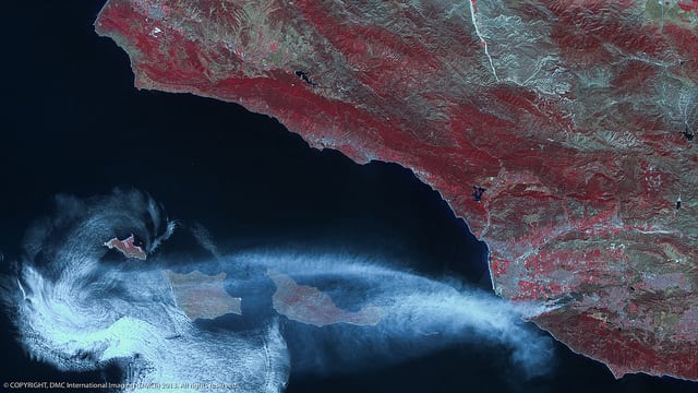
California Wild Fires photographed on May 2, 2013 by UK DMC2. Photo: DMCii
[Via Satellite 04-15-2014] With the number of Earth observation (EO) satellites planned on the rise, the planet is nearing a point of regular photographic coverage. A powerful application for such imagery is in disaster planning and relief efforts. However, David Hodgson, Managing Director and CEO of DMC International Imaging (DMCii), the company that manages the Disaster Monitoring Constellation for the International Charter for Space and Major Disasters, says that governments and the industry in general ought not get comfortable yet.
“We still need more assets in orbit to really be able to relax and not have to worry about data being available when we need it,” Hodgson told Via Satellite. “For the time being, and I would say for at least the next five years, we are going to have to still be working in a mode where things are going to have to be pre-planned.”
Hodgson, whose company recently signed an agreement with Netherland-based environmental sustainability company eLEAF to provide irrigation data for African farmers, said that most of DMCii’s past work has been post-event, but pre-planned coverage is becoming more common. Countries with a strong federal approach to geospatial data lead the pack when it comes to acquiring such imagery, and nations that are subject to cyclical disasters can schedule imaging campaigns on a seasonal basis.
“There is a general ability for those countries to be able to know that a disaster will happen,” said Hodgson. “For example in Nigeria we know that flooding really starts around May. What we can do is schedule imaging campaigns pre-event, during the event and after the event, because all are equally important to help with the clear-up and post-event mitigation activities.”
DMCii partners with countries to build and operate their own satellites. The company’s most recent projects include three optical satellites with Twenty-First Century Aerospace Technology Company in China, and a radar satellite called NovaSAR, for which the hunt for partners was described as “rapidly evolving.” DMCii is working with Surrey Satellite Technology Limited (SSTL) to accomplish 1-meter optical imagery. As the trend toward proactive instead of reactive behavior continues, Hodgson added that nations are realizing that scheduled satellite imagery coverage on a routine basis is a valuable national asset.
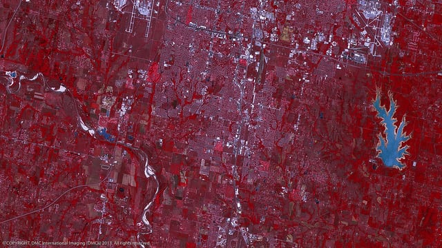
Moore, Oklahoma prior to a tornado, photographed on June 5, 2011 by UK DMC2. Photo: DMCii
“I think it’s something that is probably still developing,” he said. “Most people tend to assume that imagery is always available and new imagery can be acquired and compared. I think we are heading in that direction with more satellites providing higher frequency and a wider area of coverage throughout the globe, but we are still at the point where most countries are relying on national or federal bodies that are proactively archiving, collecting and making available national data to portals for this type of imagery to be available on demand.”
One of the ways DMCii expects more data to be available is through platforms like CloudEO, which allows customers to place orders for imagery and then choose the best option. As more constellations come online, this could be another way for disaster management teams, as well as industries in environmentally precarious parts of the world, to stay one step ahead.
“For us there are a number of online portals,” said Hodgson. “I think we are seeing the early days of the emergence of cloud-services for Earth observation, and it is a technology whose time has definitely come. It is well used in other industries, but the data volumes and requirements for EO have been a little out of reach. That is changing very rapidly.”