NOAA’s GOES 16 Now Operational, Ready to Improve Forecasts
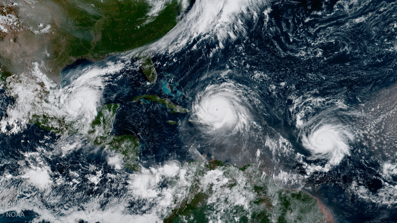
GOES 16 captured this image of three Atlantic hurricanes simultaneously: Katia (L), Irma (M), and Jose (R). Photo: NOAA.
Now in its new GOES-East position, the GOES 16 satellite has officially joined the National Oceanic and Atmospheric Administration’s (NOAA) operational observation network, providing forecasters with sharper, more defined images of severe storms, hurricanes, wildfires and other weather hazards in near real-time 24/7.
Since its launch in November 2016, NOAA’s GOES 16, even in its testing stage, showed its potential to improve weather forecasts and brought new levels of situational awareness to forecasters, emergency managers, and the public. The satellite covers most of North America — all of the continental U.S., Mexico and most of Canada, from 22,300 miles above the Earth.
“GOES 16 has proven to be one of the most important tools we’ve ever developed for our weather and hazard forecasts,” said retired Navy Rear Adm. Timothy Gallaudet, acting NOAA administrator. “From its impressive first image of Earth last January to monitoring tropical storms and wildfires, GOES 16 has and will continue to greatly improve our ability to visualize potential threats, and enhance forecasts and warnings to save lives and protect property.”
GOES 16 provided critical data which enabled emergency preparations and response during this year’s extremely active hurricane season. Its high resolution — four times higher than previous NOAA satellites — and views of Earth taken every 30 seconds allowed forecasters to monitor how and when storms developed. Data from GOES 16 allowed forecasters to better assess and predict how much rain Hurricane Harvey would produce over Texas and see its rapid intensification, along with hurricanes Irma, Jose, and Maria.
GOES 16 data helped monitor and detect wildfires, and gave forecasters detailed images of wildfire smoke, enhancing their air quality forecasts. Imagery from GOES 16 helped forecasters spot new wildfires in California, Kansas, Oklahoma, and Texas, and determine which fires were hottest and where the fires were spreading. This critical information was shared with and used by firefighters and emergency managers.
GOES 16 testing also showed potential improvements for aviation weather forecasting and airport operations. Forecasters are now able to predict with greater accuracy than before when fog and clouds will form and clear. The new satellite can also detect turbulence, enabling forecasters to issue timely advisories, aiding in aircraft and passenger safety.
GOES 16 is the first in the series of next-generation geostationary satellites that will provide valuable data in support of NOAA’s Weather-Ready Nation initiative. The next new NOAA satellite, GOES-S is scheduled to launch March 1, 2018 followed by GOES-T in 2020 and GOES-U in 2024. These satellites will enable NOAA to more closely monitor weather systems over North America, South America, and the Atlantic and Pacific Oceans, to help protect lives and property.